In brief: We’re less than two days before the landfall of Beryl and there are still plenty of questions about the severity of impacts in Houston. This post will attempt to answer those that we can. In terms of planning, it is becoming increasingly clear that Monday, perhaps from the pre-dawn hours into early afternoon, will be the most impactful time for severe weather.
Status of Beryl on Saturday afternoon
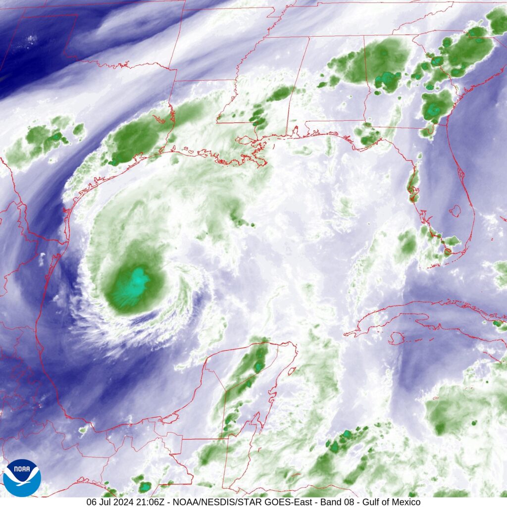
Good afternoon. As of 4 pm CT, Beryl remains a strong tropical storm with 60 mph winds and a slowly dropping central pressure. It’s movement is northwest, and it remains on course to make landfall in Texas on Monday, likely during the morning hours. There remains a fair bit of uncertainty about precisely what winds, surge, and rainfall the greater Houston area will experience.
You’ve probably noticed the showers and thunderstorms—there has been a lot of thunder and a lot of excited dogs down my way—this afternoon. These storms are not directly related to Hurricane Beryl, but rather are due to a dying front meeting up with the sea breeze and having a party with the peak heating of the day. These storms should sag toward the southwest this evening before fading out by or before sunset. After that we can expect a quiet night, I think.
Starting on Sunday, perhaps by noon, we may see our first rains from the outer bands of Beryl. However, there should be few mobility issues with making final preparations before the hurricane reaches the Texas coast. I expect stronger winds to begin reaching the coastal areas on Sunday evening, so if you live in places such as Galveston Island or Freeport, you’ll probably not want to be out too late. After midnight our region will start to feel the full effects of Beryl, and which I’ll talk about below.
However, before jumping into the forecast I want to share a couple of housekeeping notes.
Housekeeping notes
Find us: There are lots of ways to find and follow Space City Weather online, and to be sure you know when we post updates. We’ve created a page to help you find us on social media, via our (absolutely free) app for your phones and tablets, an email newsletter, and more.
Video Q&A: I’m planning to conduct a Facebook Live on Sunday at 1 pm CT. The purpose of this will be to answer your questions over the course of about 20 minutes (or longer, if there are more questions). You can queue up questions in the comments below, or on Facebook. We’ll also be taking questions live, during the event, which will take place on our Facebook page.
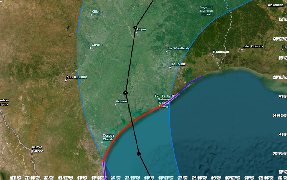
Beryl’s track and intensity
As expected, Beryl is spending most of today fending off dry air to its south, and wind shear to its southwest. The storm is starting to develop better organized thunderstorms, however, and it should slowly begin to intensify tonight. Sunday and Sunday night will present a more favorable opportunity for intensification, and the National Hurricane Center brings Category 1 hurricane to the coast on Monday morning. However, the storm could be a bit stronger than this as historically we have seen hurricanes quickly gain intensity as the near the Texas shore.
We are now only about 36 to 48 hours away from a final landfall along the upper Texas coast. But there remains a decent amount of uncertainty in the final landfall location, and even 50 or 100 miles matter since the storm is going to come inland relatively close to Houston. Our forecast models are pretty good, but we’re talking about relatively small errors that can still be caused by a wobble or two.
What I’m trying to say is that Houston is sort of on the edge: Depending on which way Beryl goes in the last day and a half we could see anything from fairly minor winds to near hurricane-force gusts; and a few inches of rainfall up to 10 inches or more. So my main message here is to be prepared for some serious disruptions in power and mobility on Monday, and if we’re lucky these issues will turn out to be minor. The forecast conditions outlined below are consistent with the latest operational forecast from the National Hurricane Center, which is the most likely (but not certain) outcome.
Timing and severity of Beryl’s impacts on Houston
There are three main impacts from Beryl, winds, storm surge, and heavy rainfall. Let’s go through the latest thinking on each of them.
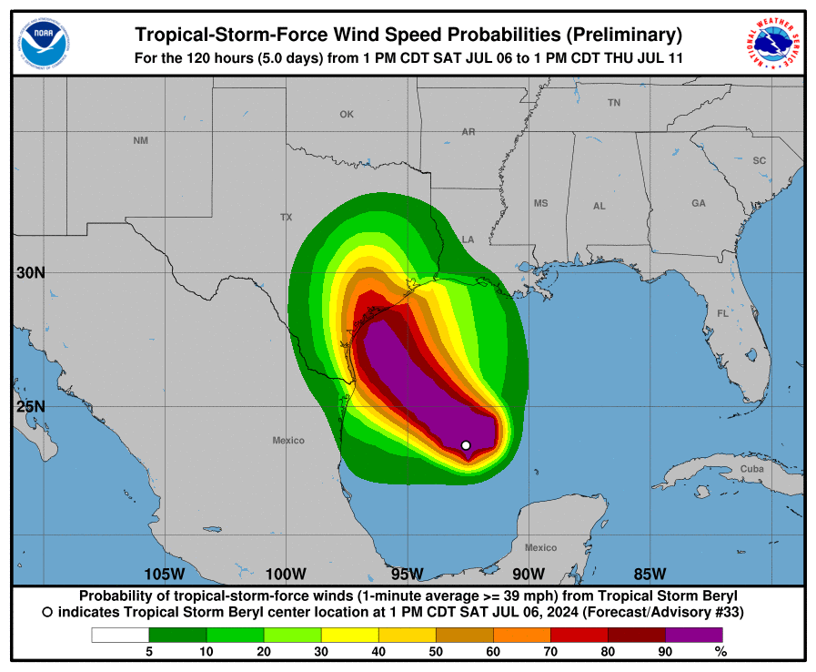
Winds: Tropical storm-force winds could reach the upper Texas coast by Sunday evening. Generally, areas along and west of Interstate 45 have the best chance of experiencing tropical storm force winds of 39 mph or greater, with higher gusts. In terms of potential power outages, I’m most concerned about Brazoria and Fort Bend Counties, and areas generally south and west of Houston. Again, the extent of our concerns about power losses will be driven by the potential for last second wobbles which will (or will not) bring the core of stronger winds closer to Houston.
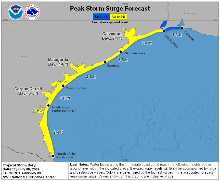
Storm surge: Our thinking on storm surge has not changed much, with 3 to 5 feet expected along Galveston Island, and 2 to 4 feet possible in Galveston Bay. This surge is likely to peak on Monday morning, as Beryl nears land, and on top of high tide. Tide timings vary by location, but generally the highest water levels should be anticipated between 6 am and 9 am CT.
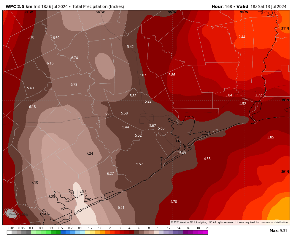
Rainfall: We’ve issued a Stage 2 flood alert for the entire Houston metro area, but like with Beryl’s winds, the risk for flooding is greatest along and west of Interstate 45. My best guess is that the strongest band of thunderstorms will move through Houston sometime on Monday morning, perhaps between sunrise and around noon. This likely will produce the most intense rainfall, and the greatest potential for rapidly flooding streets. If you have plans to be out and about Monday morning, please be very weather aware. In terms of accumulations I think most of the area will pick up 4 to 8 inches of rain, which is mostly manageable. However, due to the tropical nature of this rainfall (which leads to high rainfall rates) some isolated areas may pick up as much as 12 or even 15 inches. That’s … less manageable.
A note about flight cancellations
I mentioned this about three weeks ago, but I wanted to reiterate that we hear you on flight cancellations. It’s a major concern with inclement weather. I totally get the anxiety. However, neither Matt nor I are aviation meteorologists or pilots. Unfortunately, we don’t have any special expertise or insight into the decision-making at airports that lead to flight stoppages, nor the cancellation of flights. We try to be helpful, but we’re never going to be able to give you the certainty on this issue that readers want. With all that said, my general expectation is that heavy rain or winds may well disrupt and even cancel some flights on Monday or (less likely) Tuesday.
Our next update
We’ll be back late this evening, probably between 10 and 11 pm CT, with a short update on track, intensity, and some thoughts on whether Houston is likely to experience milder or more serious effects from Beryl. We will, of course, have full coverage on Sunday.

should Cypress evacuate?
I thought it was hilly in Cypress?
You are thinking of the one of the coasts of Greece and Turkiye!
I was thinking of the hip hop group!
Turn around
Turn around
Turn around
H Town turn around and don’t drown
Just be prepared as best you can, and if you can and feel the need to evacuate out of the way, then do so. Always do what you feel is best for you and your family. Best of luck.
Good “practice” storm to get ready for a major hurricane. Done let gas tank go below 1/2 and always best to too off when you can if storm in Gulf
Would you recommend boarding up windows we live about 2 miles from kemah in league city?
Mike
No. We live about 3 miles from Kemah. This won’t be bad even if it’s a direct hit.
Would you recommend boarding up windows? We live about 2 miles from Kemah in League City?
Thanks yall. Appreciate the coverage.
I’m flying out of hobby on Tuesday night. Any idea of what that’ll be like?
I think it will be fine. (But also please read the section on “a note about flight cancellations” in this afternoon’s post!)
Your flight out depends if they get the plane IN beforehand. Many flights will be cancelled on Tuesday due to lack of aircraft on Monday
Wind go down rain down
Thanks Eric and Matt. Excellent coverage!!
Wow! we just had a 41 mph windgust at the Angleton airport from the rain cooled gust front produced by these storms.
Thank you!
Admit it. Ya’ll blew the forcast again today. Heavy winds and 3 and 1/2 inches of rain. North Galveston County. Why should I listen any longer to your guesses? I’ m done with SCW.
Oh no! Someone on the internet is mad at me! I’ll never recover.
Seriously, if we’re not doing it for you, I definitely encourage you to find your information elsewhere.
Eric
Love your response
Your info is always appreciated
Keep giving us your informed insights and we will use our God given brains to analyze and interpret your information
Great reply Eric!!! You guys are the best!!!! Ever since I found you during Harvey, I have found you to have the MOST accurate forecasts of anyone in the Houston area and totally without hype. Thanks so much for what y’all do for Houston!
I am offended, I am a millennial kissing butt over here. How dare you call me a boomer!
How will they ever go on?
Good; go troll somewhere else!!
Not a drop of rain in magnolia. Lucky you.
This isn’t an airport, you don’t have to announce your departure……
Good riddance – but good luck to you anyway.
I’m sure you will be missed! 🙄
They’ve been consistent with most of the other forecasters as well. I like to follow them and the eyewall, Jeff Linder, and Travis herzog. Them I take from all 3 what I will. I’ve never seen a meteorologist be 100% accurate, 100% of the time. I think you need to eat a snickers.
Lol. This one was pretty complicated. NHC missed early one, everyone did. Nature of the beast.
You are a more on. It’s a FORECAST, which is an educated guess!
Bye..🖐🏾
Thanks for all you guys do!
Should Lake Jackson board up windows, and how high is our risk of flooding, as in getting into homes? Thanks in advance.
I really need to know your elevation to answer the risk of flooding. Regarding boarding up your windows, if it were me, I probably would not. However, if it is relatively easy for you to do so, maybe it’s worth it?
Thanks Eric and Matt for your always informative updates. I look forward to reading every one when they become available.
New merch suggestion?
“Space City Weather – Where there’s Beryly any hype.”
My plan is to memory hole Beryl soon after it’s gone.
Great Job, Eric! As always, thank you for the insightful updates!
We’re supposed to be in Katy at 1pm Monday. Should we reconsider? :-/
I’d definitely reconsider!
Depends on where in Katy and the rainfall rate. Some areas flood quickly and others don’t flood at all.
Yeah, but I wouldn’t want to be on 10 during that, flood or no flood
Eric, I love your calm, insightful and sometimes humorous reports.
Thank you!
Thank you both for all that you do!
This is not the July birthday gift I asked for, thanks.
In all seriousness, thanks again for all you do. I work earllllllly most days (I’m a buyer for a grocery store, be nice to us over the next day or so, please) and I rely on y’all to see whether or not I should be driving in to work at 5am. Cheers! Stay safe, everyone.
Thank you, SCW! Appreciate your updates!
Thank you guys so……much for always keeping us updated. We truly appreciate it!
Thanks, guys!
We are supposed to drive from Houston to Victoria (and back home) Sunday afternoon/evening for a birthday party.
Any thoughts?
Should be OK; but better to leave earlier than later.
Sunday afternoon and evening? I think I would send my regrets.
This storm, “B”, has been unique from it formation. Any other storm that defies logic like this one will be called “Son of a B”
Was really wanting to hear it turned some other direction. My wonderful neighbors chopped up a couple trees today leaving them filled up 5ft tall all along the curb including over the dang storm drain. Just brilliant
Keep up the good work, thank you.
Well, Im supposed to be moving Monday morning 😔 Hope all goes well. Ugh.
Monday morning during the peak of the storm? I’d go with Plan B.
well, if the movers show up i’ll be moving…. it’s only 10 mins away from my current place (downtown houston). fingers crossed!
STOKED about the App!! SCW is the ONLY place I trust! #YouHadMeAtHarvey
Flying out Monday to Vegas, should we change flight to tomorrow, flying with kids
Plz read his section “A Note About Flight Cancellations.”
Thank you.
I’ve had flights cancelled for lesser reasons than a hurricane. Check with the airline. I doubt Monday will be an option for Hobby and IAH.
Google Houston Airports – Hurricane Beryl. They are providing information. United is already offering free flight changes. I have a flt Monday morning which will surely be cancelled
I’m forever shocked that people expect you to know down to the street nearly when and where storms will land and what each neighborhood will see in rain and wind. Forecasters aren’t using a joystick to maneuver a hurricane. This is Mother Nature doing whatever she wants. Smh. I do appreciate the calm direct facts as you obtain them, as well as possible paths and outcomes to plan accordingly. Too many rely on the scare tactics and big “end of times” dramatics of the tv forecasters. Learn your area/roads and how they will be, prepare for what your home/family personally needs… & follow more than one resource for storm information, esp if one is consistently giving doomsday reports.
I live in bay city but I’m visiting my daughters in Austin. My plan was to return home to bay city tomorrow (Sunday). Should I reevaluate my travel plans? Or would I be ok to leave Austin tomorrow morning?
I am totally confused, in the same paragraph you say 4-8 inches of rain with some areas receiving 12 ton15 inches of rain. Which is it? Am I reading it wrong? This morning it was going in at CC or Matagorda and now coming in near Houston? I have terrible PTSD from Harvey, can handle 4-8, but 12 to 15 I am screwed.
Most areas are likely to see 4 to 8 inches of rainfall. However there are some isolated areas, likely 10 percent or less of the Houston region, that will see higher totals than this. The upper risk is likely 10 to 15 inches. That’s what we’re trying to communicate. This will be markedly different from Harvey because the heavy rains will be over much more quickly.
I’m driving to Houston from Dallas on Monday. Maybe not?
Well, it’s not optimal timing that’s for sure. If you can wait a day I would.
Family is suppose to drive down to Crystal Beach Monday morning. Can’t tell yet if we should we just go Sunday evening and get settled or if the whole trip in jeopardy.
I’d say head down Sunday, it’s likely that HWY 87 will get water high water Monday morning, especially with landfall and high tide corresponding, probably similar to water levels from Alberto a couple weeks ago.
Thank you for such detailed coverage. We are driving home to Montgomery tomorrow from Florida, and your updates are helping me to figure out the timing of the trip.
I’m supposed to have an appointment Monday morning in the med center. Given the risk of rain, should I consider cancelling?
I changed my heart doctor appointment. 🤷🏼♀️ you might consider it.
Since I live in the Cypress area among the tall trees, wind is my main concern!
We lived in Windwood subdivision – acreage community in Cypress. I you blinked driving by our house, you’d never see it because of all the trees (60 ft+ pines and others).
.
House doesn’t exist any more, due to Harvey. As well as many other homes.
.
As Cypress is huge, you may not be anywhere near where we were.
Near Cypress Creek and Huffmeister – a lot of homes around me got crushed in the derecho!
Anyone else notice the electronic traffic signs telling people to visit the Galveston seawall? I thought it was a joke at first.
We saw them too.
Hi Eric & Matt,
Do you have a guesstimate as to how long we might be stuck in one place due to flooding on Monday? For reference, I live inside the loop. I do hospice-care pet sitting and have a client I will need to visit, so I’m concerned about how long I may be cut off from him.
Thank you!
To make it easy: Please reconsider any travel Monday. Flying, driving, etc.
Airlines will issue waivers and it is much easier to reschedule now than to wait for them to cancel. Enjoy another day in a lounge chair— not in an airport . Wait a day or two to start your vacation. Postpone your procedure or appointment. Just do it.
We’ve considered heading to my parents’ place in Conroe on Sunday night (or Monday morning), but would it be any less affected by the storm than our house in the Heights? At least their power lines are undergrounded and they have a generator.
Should The Woodlands/Conroe be terribly impacted?
can you give any details for Friendswood tx? Thank you so much 🙏🏻
Speaking of pilots, I are one. Flights are not cancelled because of rain, but they are cancelled because of thunderstorms and high winds. Thunderstorms are characterized by turbulent air which can make landing and takeoff dangerous, and can even rip an airplane apart. High winds at altitude are no big deal but at the surface they affect airplane handling. If they’re straight down the runway, no problem but airplanes have crosswind limitations. A line of thunderstorms will play havoc with airplane handling by air traffic control due to diversion to avoid storms.
First off, thanks for this! Just discovered you guys and am so happy I did. Not asking for a crystal ball obviously, but if you had to guess what the storm will look like into the week as it goes inland? Lighter and lighter? Or total awfulness all the way to STL and beyond? Thank you!
Thanks so much! Any thoughts on potential Dallas and Austin impacts as far as wind+flood damage? I’m running a biotech study out of Rice/med center with some clinics over there that involve time-sensitive couriers/shipping. Hoping in the worst case we can personally drive things back/forth between the three cities by Thursday if FedEx is still disrupted.
Always evolving but very helpful. Who in their right mind would think that the forecast can be 100% accurate. I appreciate the site. These guys work hard and do the best they can. Succinct.
I’ve been a loyal reader since Harvey. You guys are usually spot on, the rest is due to the vagaries of meteorology and modeling. Our family really appreciates what you do!
Any thoughts on Sweeny as far as whether we should be boarding windows or not?
I live just outside of the East Loop, do you recommend that I board up my windows?
Ps. I think the service yall provide is awesome!
Thank you for keeping us informed. Do you think the Katy/Cypress area will see 80mph wind gusts on Monday evening as some weather sites are predicting? It confuses me because even the Matagorda forecast is not too different, and that is close to where the storm may make landfall.
I live in Brazoria in an rv. Should I be concerned
I would either stay with friends/family in a house, a well built motel/hotel or head to somewhere out of the storm’s path like San Antonio.
RV would not be safe in tropical storm/hurricane conditions.
My friend is flying home from Cincinnati to Albuquerque on Tuesday afternoon. She is planning on baking a casserole once she gets there. Do you think she should serve blueberry cobbler or chocolate pie with it? I’m wondering what I should tell her.
I’d say blueberry cobbler.
Really, she may not be a pie person, I think you should consider a lemon custard as an extra precaution.
Have her bring ice cream from home in case our stores are all closed.
Blueberry. Always.
If landfall is 10am, then we can expect the power to go out at 9:59. If the storm blows through in 12 hours, expect the power to be off for 12 days.
Curious what the risk for tornados is in the Houston heights area? Ready for Beryl to get on out of her
I’m hoping my electricity stays on, that there are no tornadoes, that the rain is what they predict, 5-6.” If so, we will be fine. But just in case, I’m headed to Spec’s!
Would overnight tornadoes be possible in the expected conditions? We are located in Sugar Land area. Thank you for everything that you do!
Traveling back into town. Which is better- drive in Sunday evening and be there for the storm? Or stay the night in San Antonio and be driving in Monday afternoon? Can’t figure out if we’ll be driving in some rough conditions by then?
My 16 year old son is supposed to leave Monday morning early from the Richmond/Fulshear/Katy area around 8 AM on a road trip to Grandbury Lake (just south west of Fort Worth) with his friend and his friend’s parents and another family to go to a lake house for a vacation until next weekend. (My son was invited to go with these two families) I’m very concerned about flash flooding and wind, but especially the torrential rains predicted during that time that could cause flash flooding trying to travel north. Would you recommend that his dad and I cancel that trip that he’s been invited on? My momma instinct is to cancel him going, but I’m not sure if I’m going to be able to convince my husband and my son that it’s not safe and then I will be the parent who is the big party pooper. But it’s not worth it to risk my son’s life though. What do you think I should do?
Marcia. Be the party pooper and speak up. It’s ok because it’s what Mom’s have to do sometimes. I would not want my son on any road on Monday. Just don’t worry about him being disappointed. In the big scheme of things he will get over it.
Leave a day later?
Thanks guys for spelling it out as best as you can. Mother Nature will always throw you a curve ball when you least expect.
I am supposed to drive to Port Arthur Monday by 10am to close on a house. Reschedule?
I am a student in Galveston and class was cancelled on Monday and might be restarting on Tuesday. Should I drive in tomorrow and stay in Galveston or travel in on Monday? It’s hard to tell since they have not said anything about Tuesday. I live in the SW houston area.
I’m suppose to work on Monday starting at 7am sw / beechnut area and a family member drives to med center to be there at 7. Should we reconsider going in
I have a dr appointment on monday morning in cypress. Should I wear my green pancho or my multi colored umbrella hat?