In brief: Although we cannot be certain at this time, it increasingly looks as though Tropical Storm Beryl is on track to make landfall somewhere between Corpus Christi and Matagorda Bay on Monday. For the greater Houston area this will result in higher winds, some storm surge, and heavy rainfall, with the greatest impacts likely on Monday. This post goes into what to tentatively expect, and when.
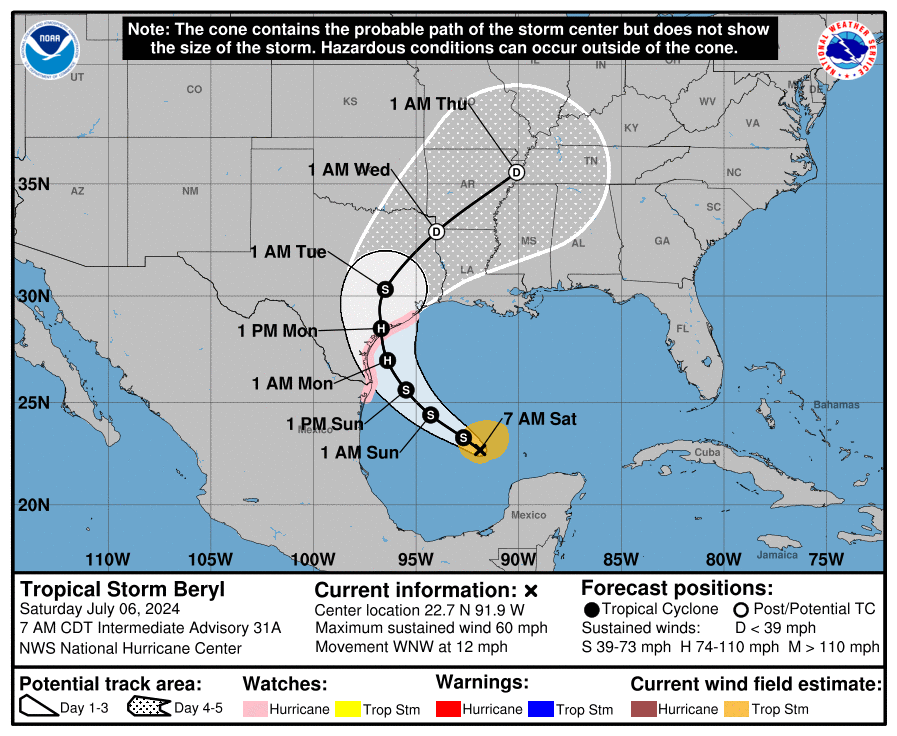
There is understandably a lot of consternation about the forecast for Beryl, which shifted considerably northward during the last day or two toward Houston. However, overnight the majority of our model guidance has stabilized on a landfall along the Coastal Bend of Texas, somewhere between Corpus Christi and Matagorda Bay.
Given the unpredictability of Beryl to date, I don’t blame anyone for being skeptical about this forecast. However there are a couple of reasons for increased confidence. Most importantly, we are only about 48 hours from landfall, and the average track error at this point is approximately 60 miles. And secondly, the models have stopped swinging about wildly and begun to consolidate on a solution.
In this post, we will discuss the effects of this “most likely” storm path on the greater Houston area, from Katy to Baytown, and Galveston to Conroe. For effects across the entire state of Texas, I would point you to The Eyewall. We will update Space City Weather a couple of more times today, and if our thinking on the forecast track changes, I will post immediately.
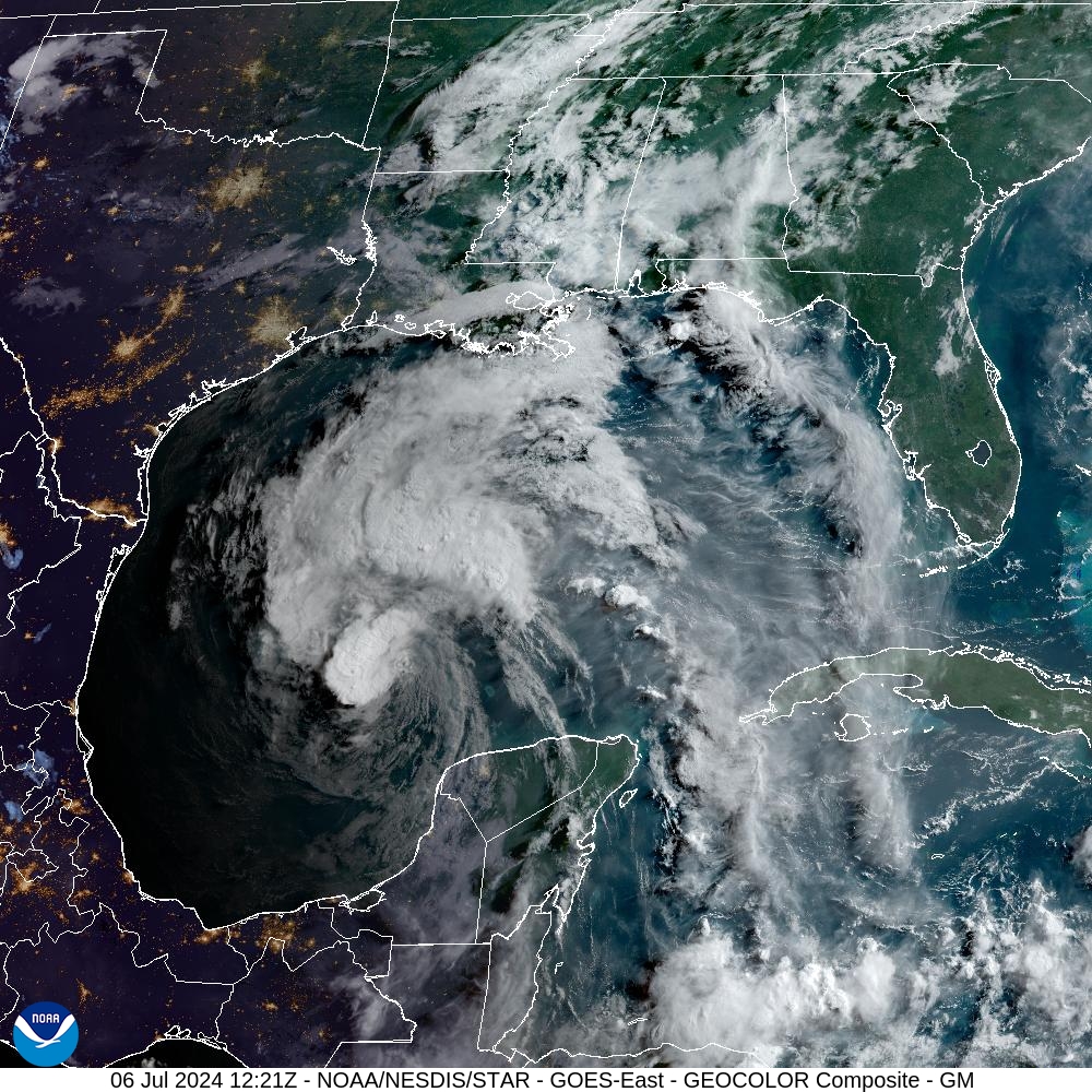
Hurricane Beryl’s status and track
Beryl emerged into the Gulf of Mexico as a ragged storm on Friday evening, and has since been struggling with drier air to its south, and wind shear to its west. As a result, as of 7 am CT, the storm has sustained winds of 60 mph. In terms of intensity, it will take Beryl some time to regain its organization, but by tonight or Sunday, it should move into an area of more moisture and lower wind shear, allowing for strengthening. It’s really a matter of how long it takes Beryl to get its act together, because once it does it will find conditions favorable for intensification. The official forecast calls for a Category 1 hurricane at landfall on Monday, but it could easily be a tropical storm or Category 2 hurricane.
In terms of track, Beryl is moving around the western periphery of a high pressure system, and should gradually turn more and more northwestward until moving due north around the time of landfall. That should come sometime on Monday morning, although the precise time is difficult to predict. The likely landfall location is between Corpus Christi and Matagorda Bay, but for now the greater Houston area remains within the cone of uncertainty.
Effects on Houston
Let’s go over the anticipated impacts on the greater Houston region, including winds, surge, and rainfall.
Winds: Along Beryl’s expected track, the system is unlikely to produce significantly damaging winds for much of the Houston area. The greatest risk of tropical storm force winds will be in Southern Brazoria County, and locations such as Freeport and Lake Jackson. Galveston Island will have about a 50 percent chance of tropical storm force winds, with higher gusts. Strong winds would likely arrive late Sunday night, and persist through Monday.
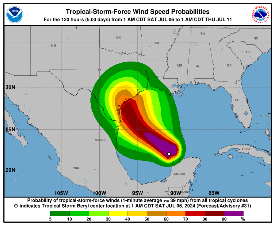
As Beryl moves inland, its center should pass to the west of Houston, so areas such as Sugar Land and Katy will also have a decent chance of seeing tropical storm force winds and higher gusts. If there are power outages, I would expect them to occur to the west of Interstate 45. However, at this time I do not envision a situation in which hundreds of thousands of customers in Houston lose power for a long period of time. Still, it’s something to monitor. The likelihood of seeing hurricane-force winds anywhere in the Houston metro area is virtually zero.
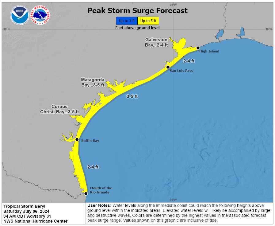
Storm surge: Areas along the upper Texas coast, including Galveston Bay, are likely to see 2 to 4 feet of surge at high tide. This surge should peak on Monday morning. The effect should be similar to what the region experienced with Tropical Storm Alberto a couple of weeks ago.
Rains: Beryl will bring plenty of tropical moisture with it, and the Houston region will likely see heavy rainfall on Monday (most likely) and Tuesday. In terms of accumulations, I would expect much of the region to pick up 4 to 8 inches, with higher isolated totals. This could well cause some flooding concerns, and we are initially issuing a Stage 2 flood alert for the Houston region. This means we expect widespread street flooding, and the potential for some homes to flood. As Beryl will continue moving northward after making landfall, I don’t think we’ll need to go higher in our flood stage warnings. We should get a better handle on timing of the most intense rainfall in a day or so.
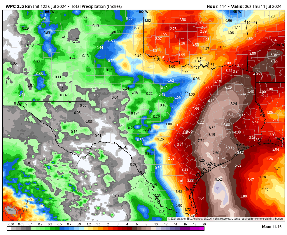
In summary
Beryl has been, to say the least, a challenging forecast. Fortunately, we are in the home stretch. You have all of today, as well as most of Sunday, to make any final preparations. We will have an additional update on Space City Weather by 5 pm CT today. However, if there are substantial changes in our thinking, we will update before then. Thank you for your patience and trust.

Been checking this morning to see the update. Thank you for being on top of it to the best of your abilities. We will finish shopping for last minute needs in case the power goes out. 🙂 May you all stay safe as well.
We are supposed to be leaving Monday morning from Crosby going to the frio river. How will the drive down I-10 be?
Depending on the timing, not great. Some chance of tropical storm force winds (difficult but not impossible to drive in) and pretty good chance of heavy rainfall. Bottom line: at this point the drive is somewhere between manageable and dangerous.
Would lake Charles area be safe from this
Dude. Lake Charles is nowhere near where the storm is making landfall.
One, it is a lady, not a dude. Two, be respectful. Lake Charles got clobbered by two storms a couple of years back the were originally forecast to hit around the Houston area.
I am sure the Concan area was hoping to get some beneficial rain from Beryl. We just left the Frio and there is essentially no flow to the river at all. I have been visiting for years and never seen it with so little water. Sounds like you will have rainy drive down I10.
Perfect conditions for flash flooding in Concan and most of the Texas hill country…
Crap! My daughter is camp-counseloring in a canyon on the frio river in Leakey!
I think they should cancel the camp! If my child were a camper, I’d go pick them up.
Wet.
Thank you for your diligence in covering Beryl for us!
Thank you guys! It’s reassuring to have reliable folks to report to us!
Hi Eric. What about rain, wind effects in the Beaumont, Lumberton area? Thanks for the update.
The maps in this post include information for those areas. All effects should be less severe than those outlined for Houston. Should be entirely manageable, imo.
Supposed to be flying home tomorrow and landing at 5pm CT Sunday. Do you expect impacts severe enough at that time to cancel flights?
And we are supposed to fly in Monday 5pm. Please comment on both timings. Thanks!
https://www.click2houston.com/news/local/2024/07/05/those-planning-to-travel-through-houston-area-advised-to-plan-ahead-of-hurricane-beryl/
I have a flight out of Houston on Monday afternoon and I’m wondering the same thing.
Not if you live in Boston.
Flying from Northwest Arkansas to Houston Monday… any concerns here?
Eric and Matt, flight impacts at hobby airport Monday morning?
Expect the major airlines to issue a weather waiver beginning sometime today or tomorrow allowing you to reschedule your flights at no charge. I personally wouldn’t fly on Monday as delays and cancellations will be significant.
• loads freezer with blue ice
• unpacks new solar powered lanterns and solar powered phone charger purchased after derecho
✔️ ✔️
Thanks for all you guys do to keep us informed so we can prepare.
(Restrains self from posting running joke re Katy)
Thanks. Katy evac jokes are so old and tired and waste of space now.
Do you think conditions will be bad enough on Tuesday morning at Hobby to impact outgoing flights?
Lots of storms have intensified rapidly within the 24-48 hrs of landfall, including Harvey. Why is that not expected for Beryl considering it’ll have 24 hrs without the dry air and winds shear currently preventing it from intensifying?
It can. That’s why he said it’s expected to be a cat 1 at landfall, but could be a TS or Cat 2. All depends what it does over the gulf now.
How would conditions in La Grange be?
So will Houston be closing down? I do appreciate your honest forecasts that are not fear mongering but I operate a licensed home daycare and I have families asking me if I will be open because their jobs tell them to be at work unless the city closes down but with the forecast being so uncertain it’s hard to make that call.
I don’t understand weather at all but I have been through a lot of hurricanes starting with hurricane Alisha when I was a kid and back then it seemed like they knew when a hurricane was coming at us for sure and when they said it would hit it did indeed hit so what seems weird to me is we supposedly have better technology yet this storm has been ridiculously unpredictable. Not complaining just an observation.
Like you said, this storm has been unpredictable so its difficult for an accurate tracking of landfall, rain and intensity right now.
Keep checking today and tomorrow for updates, make a reasonable decision whether your business should be open Monday-Tuesday
I’ve been thru a Cat 1 like this coming one, and it was like a blow dryer of wind in face for 5 hours but didn’t rip off roofs or wreck my boat on ocean but bounced it lots. And 10 miles inland even this is mostly gone. Beryl when became Cat 1 at 3 days should’ve made us all VERY relieved, a small Cat 1 storm is like a Kitten and not like a Cat 5 T-Rex.
Anyone 10 miles inland will feel light wind and rain Monday, by end of Monday flooding may occur in spots. Harris Co libraries probably will stay open I hear.
My understanding is the weather is more unpredictable these days because of climate change. The waters are a lot warmer, which affects the development of hurricanes. That Beryl developed at all was the first strange thing about this storm (it’s a bit early in the season) and it’s because the water out in the Atlantic is so warm right now.
Maybe Eric can confirm my take on this, but I think part of that perception (and I do think it’s a perception, not fact) is, ironically, how much better we’ve gotten at tracking and predicting weather. Back in the late 70’s and 80’s when I was growing up here, we didn’t have modeling capacity as far out as we do now. The thing about longer range models is they have a wider range of possible outcomes. So, there’s more of a chance the outlook will change from first prediction to landfall.
Thanks, guys. I’m going to head outside now and tie the dog to the tree so he doesn’t blow away.
(This is NOT real, btw, just a call-back to another Ike-era question that appropriately drew Eric’s ire back in 2008.)
Thank you for your updates & all your efforts to keep us aware!
Please help Eric and Matt, for us to make decision, we are flying Tuesday morning for vacation to Denver, what are the chances of cancellation at IAH?
I don’t mean to be rude, but there are so many questions about flights (which I am sure Matt and Eric have no answer for, like they have told us in the past). What decisions are there to make? Either your flight will be cancelled or it won’t, you just have to wait and see. My sister and I were meant to fly out the Friday after Harvey and couldn’t because the airport was still closed. We called our hotel and they were happy to give us a full refund because there was a hurricane which was totally out of our control.
I’m supposed to move from Houston to Dallas Tuesday. Do you think I’ll be impacted on getting out of the worst of it is Monday? I’m near NASA.
As far as I can tell, other meteorologists I follow seem to have abandoned us bc it’s the weekend or are using us for scare clicks.
TY FOR YOUR AUTHENTICITY. For being with us and for giving us your years of learning and experience and asking for nothing in return.
Thanks for the updates and all your hard work to keep Texas families safe and informed!
Thank you for always being on top of our weather forecasts. We are supposed to RV camp in Waco (leaving Sunday) for a week. Unsure of forecast there?
At T minus 3.3 days when at Yucatan we thought Tamaulipas, 900 miles away, on the “normal slight right path” from speed+angle+coriolos. At 2.7 days shifted to corpus when 800 miles away, 130 miles shift. This using 800 miles was 10 degree shift, like going from 10 o’clock on clock face to 11, so NOT a huge shift. Is my math right? And I fell self, a medium surprise doesn’t mean all bets are not off, statistics still apply, this was never gonna hit Tampico or NOrleans for instant. A in Kemah.
Thanks guys… I know you’ve worked hard on forecasting Beryl. I appreciate your focus on this storm, and I thank you for all you do. I know much of it is a thankless job, and that’s sad. You provide a valuable service for the city of Houston which none of us should take for granted. Please keep up the great work!
We have a trip scheduled in Orange Beach, AL and were supposed to leave Monday morning. We were thinking we should leave Sunday and go at least half way. Do you have any idea how Beryl will affect rain in Louisiana? We don’t want to be caught in any flooding situation.
What will the forward speed of the center be as it passes Houston?
Flying out of Hobby to LAX on Monday at 7am. Are we good there?
I have relatives who live just southwest of Houston. Always appreciate your latest forecast updates, Eric and Matt. I share them with my relatives there and ask them to subscribe to both the Space City Weather blog, and to The Eyewall. Thanks for all you do to keep everyone informed, and safe! – Sid Sperry, SPIDI Technologies, LLC, Guthrie, OK.
Hi,
I’m clueless when it comes to lawn care. Would this be a good time to plant seed since we’re about to get so much rain? Looking for anyone to assist lol.
Seeding turf is problematic in our region and most advice would be to never ever use common bermuda seed. That stuff is bad news. I’m thinking that aside from that, planting seed ahead of a deluge risks a large portion of it washing away. The time of year is important, too. If you have already made the purchase, read the instructions and consult the internet to verify this is the best time of year for the species you have selected.
“The likelihood of seeing hurricane-force winds anywhere in the Houston metro area is virtually zero.”
I don’t mean to nitpick, but I’m not sure virtually zero is the best way to put it. While chances are low AT THIS TIME, it’s not out of the realm of possibility that this could rapidly intensify to say a cat 3, nor is it out of realm to wobble or turn a little more sharply and land a little closer.
I like “virtually zero”, though just saying “under 1%” would say what this phrase means. Forecasters should use %. The storm is gonna pass 150 miles to west, not close, it’s good to say when we can relax. Save energy and evacuation money for August!
150 miles? Right now official NHC track goes directly over Columbus, which means it would pass 75 miles west of downtown Houston. Might want to refresh your tracker.
It’s already flaring up convection around the center this morning and the warmest waters won’t be crossed until tomorrow.
Thanks for the update. Very helpful.
I fly to Philadelphia Wednesday morning at 4:30 am
Do you think my flight will be cancelled due to the weather? Can I even get to the airport from clear lake?
Has the Tiempo Ciudad Espacial site been taken down for good? I just get redirected back to the English site.
The travel advice / flight cancellation queries…come on! Really?
What is the surface ocean temperature, and ocean temperature at depth of say 150 feet below sea level in sigsbee escarpment in Gulf of Mexico these days?
This will be key variable for any extreme rapid intensification.
My parents are supposed to be flying in Monday. Do you think iah will be operational? I would be driving from clear lake up 45 or around Sam Houston east to pick them up. Maybe they should delay.
How does one prepare for potential tropical storm force winds in the Katy/Sugarlabd area?
Mostly just secure outdoor objects that could fly around. There’s really no need to board up windows or anything. And be prepared for a possible power outage, make sure you have food you can eat that doesn’t need to be refrigerated as well as water stored up. After the derecho I bought a battery operated fan and one of those power banks to charge my phone, but whatever you need to get through a power outage will be up to you.
Hold on to your Diet Coke can really tight.
You guys are doing a heckuva great job and we, your ridiculously loyal followers, are beyond grateful. Thanks so much!
Thanks Guys. This things been a bugger from the get go. Overall…I think you have done an excellent job considering the overall circumstances. No complaints here.
We are sending our 9 year old to camp near Conroe on Sunday afternoon. We think it’ll be rainy but overall safe (they have plenty of indoor buildings including her dorm) and perhaps safer than we will be just SW of the 610 loop. Sound about right?
Thank you Eric! Thank you Matt! I hope at least Beryl’s craziness has contributed some useful hurricane data.
Thank you for all of your hard work. You are my most trusted source of weather information.
This is my first storm as a homeowner and I have no idea what to do. Should I run to the grocery store? Should I fill up the bathtub? Help me, fellow certified adults
For Beryl, there’s probably not a whole lot of preparations you’ll need to make. You might want to be prepared for a short power outage on Monday (fairly unlikely I’d say), and the potential for some flooded streets disrupting car travel on Monday and possibly Tuesday. Having a little extra water on hand and a full gas tank would be prudent measures.
Thank you for the reassuring response!
I live in Crosby, does that help or hurt my situation?
I guess some people here think you are also travel / logistics coordinators. Anyway, thanks for everything you do. Can you comment on probability of storm shifting further north? Also, is Houston currently on dirty side?
It must be nice to be able to do things like “Preparing” for hurricanes. Some of us dont have the ability to do anything of the sort. I despise the summer with every fiber of my being. If the ungodly extreme heat lasting from around late april to mid november wasnt enough torture, theres the constant fear of hurricanes. My anxiety is beyond extreme for the entire hurricane season. If one worse than harvey hits, thats it for me. No way to recover from that in my situation. Every time a new storm system forms, it feels like a looming death sentence.
Hi Shendu,
If possible reach out to friends and family to help alleviate your stress, you do not have to feel alone, many are in the same boat, so to speak. It will pass, they always do. Try to focus on something positive in your life, you will get through this. 🙂
Shendu, I understand the feeling. I wish I was rich enough to have a summer home in the Rockies. Anyway, I prepare by cleaning out the storm drains and getting some big plastic containers to fill with water (to run the toilets in case the water stops working). And I buy some supplies online, like food and a camping stove and one of those big battery things. This storm doesn’t seem that it will be as bad as Ike or Harvey, so let’s hope for the best.
Call me a Pollyanna, but I’m beginning to feel sorry for the poor thing:
“Beryl emerged into the Gulf of Mexico as a ragged storm on Friday evening, and has since been struggling with drier air to its south, and wind shear to its west. “
Lol, give it 10 minutes
Same here. I thought she’d be Berylling her way towards Houston!
Hi Eric , what about The Woodlands? We re supposed to spend the whole week there starting tomorrow morning . Thank you
The progress of Beryl has been frustrating for you, if hilarious and frightening for us. But thank you for keeping us continually informed. Only a few days ago it seemed completely harmless for Houstonians and now we’re thinking of hunkering down, not to mention losing power and the other accompanying anxieties.
It’s difficult to express how much I appreciate these updates. I remember when we didn’t have this kind of information to use when planning and people all over Houston started to panic every time someone said “Possible hurricane in the Gulf.”
You sort of hid this down near the end–but this is probably the main hazard:
“This could well cause some flooding concerns, and we are initially issuing a Stage 2 flood alert for the Houston region. This means we expect widespread street flooding, and the potential for some homes to flood.”
National Weather Service predicts 6.13″ of rain for my area near Champions between now and Thursday, with about half of that amount falling Monday afternoon and evening.
I can’t imagine all the work out takes to keep up with a hurricane, but Beryl is truly one of the most difficult to ascertain where she is going. And that is merely from a very uneducated person regarding weather.
Many cheers for your efforts, reporting without terror and all your knowledge. Thank you for sharing this information in a way we can understand. Y’all are amazing in the detail you cover. Onward to Monday.
Thank you. I follow your report every day.
Thanks Eric this has been a crazy storm to deal with and I think you and Matt have nailed it again. Be gald when this storm has gone through and hopefully no one is impacted to badly.
Thank you for giving facts and not the fear and drumming up ratings the major “news” networks do.
Appreciate the updates. Any idea when the rain bands will start to hit Houston. My flight is suppose to land at Hobby around 10 pm on Sunday.
I had the tree guys scheduled to come finish off the last part of sadly taking down my HUGE 100 year old dying oak tree on Monday…in the Clear Lake area. It looks like it will be a race between the tree guys and Beryl. I’ll sleep in the guest room on the other side of the house from the tree on Monday just in case it’s Beryl for the win.
Hopefully, the rain accumulation will not be another Harvey Incident in Kingwood
Along the San Jacinto River West Fork.
Please address my concern!
Thank you!!
“Final preparations” sounds rather ominous.
Not to sound insensitive but I can’t believe some of the questions on here. How in the hell is Eric or Matt or anyone short of Jesus Christ himself supposed to know if your flight out of IAH is going to be delayed on Monday at 2pm? Your drive down to the Frio? or how your week in the Woodlands is going to be? A hurricane could be effecting the area. These do not happen every day and every single one of them is different. Having survived quite a few I can say this. Your flight may be delayed, it may leave on time, we may get less than one inch of rain we may get 20. Hurricanes tend to have bands of rain and storms that are inherently impossible to predict. The greater Houston area may get wind gusts to Hurricane force in squalls and it may not top 30 mph.
The best advice I can give is be prepared. There will likely be power outages to our SW and areas that may experience 8″ or more of rain. If you are on the coast and feel unsafe with a 5′ storm surge leave no later than tomorrow night. If you lose power it may be a few hours up to two weeks until it comes back on. That means no A/C and no internet. If you or someone you know is elderly or immunocompromised you may want to take that into consideration while devising a plan.
I have this theory that very early on Eric and Matt would try and answer these questions, instead either ignoring them or swatting them down like the nuisances they are. Hence, they live on!
When Eric was science reporter at the Houston Chronicle he use to do live chats when hurricanes approached. That’s where the infamous “Should Katy evacuate?” question originated.
Eric and Matt, sounds like you all need to be a go between the commenters and airlines. People, the airlines have apps/websites and 800 #’s. Don’t expect E & M to be your travel agent. I really feel sorry for you two, some of these commenters seem to want a down to the hour forecast for every zip code. Houston will still be functioning on Wednesday everyone.
While I’m worried about my flight being cancelled (first time to fly in a year and it is Monday morning, ugh), I mainly don’t like the thought of leaving before knowing friends and neighbors all are ok/won’t need help getting through this. (I’m not Ted Cruz, lol)
Thanks for all y’all do on this site, the rapid fire updates here and on The Eyewall have been very helpful.
Thank you for the updates. I think I may just leave for a few days but don’t know where to even go… or if it’s worth it. I am so over this weather and climate. The pay bump to relocate here was NOT worth the headaches of living here. A few more months and Houston will be nothing more than another regret.
Crazy severe wind thunderstorm just blew in near downtown. Massive lightning and loud thunder. Serious wind blowing everything sideways. And hurricane isn’t even here yet. What was that.
Mother Nature reacting to the Astros game.
It’s is storming really at by Med Center right now. Longs of thunder, heavy rain, and swirling wind. Guessing the outer bands from Beryl is already here?
Surprisingly they said it has nothing to do with Beryl. This is just one of those random summer storms.
LOL not a drop of rain for weeks then beryl shows up at our doorstep and the sky opens up…”regular summer storms” huh. Might not be a band, but it has everything to do with Beryl
Ok. But it actually doesn’t. It has to due the breaking down of the high pressure ridge (which is allowing Beryl to turn northwest and move into Texas on Monday instead of going to Mexico).
No – this is just the “regular” summer thunderstorm activity.
No. The bands from Beryl are not “here”. They’ve already mentioned that we had a decent chance of rain today and it had nothing to do with Beryl. Beryl is currently located in the middle of the Gulf of Mexico. That is entirely too far away to be feeling it’s effects.
Thanks SCW for the high quality forecasting, I follow this site everyday
With rain starting close to 2pm, we’re up to 3 inches for the past hour in the Montrose/River Oaks neighborhood. Thunder still rolling through, but the initial wind bursts at the front of the storm has died off.
Tracking data on a moving target given the surrounding weather systems must be challenging and difficult to predict with with 100 % accuracy and confidence. Trust is sometimes more important than statistical confidence.
You guys are the best! Thank you for your service.
Another east track adjustment. Gone be big flood event for west Houston suburbs. Katy bar the door !