In brief: The track for Hurricane Beryl has shifted northward during the last 24 hours, and a landfall is now expected near or south of Corpus Christi. This does increase the threat of significant impacts to the Greater Houston area, but we continue to think the system will be mostly manageable locally. Needless to say we’re following things closely.
Hurricane Beryl track changes
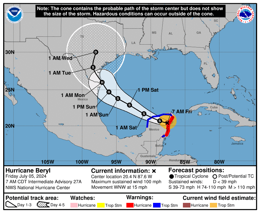
During the last 24 hours we have seen a significant move northward in the track forecast for Hurricane Beryl, which has just moved into the Yucatan Peninsula this morning. The storm, with 100 mph winds, has remained a little stronger than expected, and this supports the notion of a sharper northwestern turn in the coming days. This post will discuss the current thinking of Beryl, and its impacts to Houston’s weather early next week, which could now but a little more significant than anticipated.
In terms of additional coverage, we will share a post from The Eyewall here later this morning on the broader effects for Texas. And we’ll have an additional update this afternoon on the latest with Beryl. But first, a quick look at the forecast for this weekend.
Friday
Today will be our last hot and mostly sunny day for awhile, given the impending influx of tropical moisture. Look for highs in the upper 90s to 100 degrees for most inland locations, with slightly cooler temperatures near the coast. Winds will be very light, perhaps at just 5 mph from the south. There is perhaps a 10 percent chance of afternoon showers. Lows tonight will drop to around 80 degrees.
Saturday and Sunday
Rain chances increase to about 50 percent on Saturday as a weak front approaches the Houston metro area from the north. This is not going to bring much (any, really) cooler or drier air into our region, but it should help increase cloud cover, and allow for air at the surface to rise. Rain accumulations don’t look crazy, more on the order of passing, scattered showers most likely. As a result of the cloud cover, look for highs in the mid-90s.
By Sunday our weather may start to become influenced by Beryl, but the storm is now not expected to come to the Texas coast until Monday morning. My best guess for Sunday is highs in the low 90s, with partly to mostly cloudy skies, and perhaps a 50 percent chance of rain. This is unlikely to be heavy rainfall, as the threat of that probably holds off until Monday. Southeasterly winds will increase.
Hurricane Beryl’s track
The northward shift in Beryl’s track can be attributed to a stronger system over the last day or so, and something of a northward wobble on the Fourth of July. Our typically best performing models, including the GFS and European, and the hurricane specific models, have all shifted northward overnight. They now generally indicate a landfall between Brownsville and Corpus Christi about three days from now.
Where Beryl ultimately makes landfall will depend on how far the high pressure system over the southern United States retreats. The landfall location is complicated by the contour of the South Texas coastline, which is very nearly north-south relative to the Gulf of Mexico. This means that, as Beryl turns northwestward around the ridge of high pressure, even a relatively small deviation in course can change the landfall location significantly.
Regarding Houston, I would love to be able to tell you with certainty that Beryl will make landfall near or south of Corpus Christi. I truly think that will be the case. But as Beryl’s track has moved significantly in the last 24 hours that is not something I can guarantee you. The entire Texas coastline, for what it’s worth, lies in the National Hurricane Center’s cone of uncertainty.
Beryl’s intensity
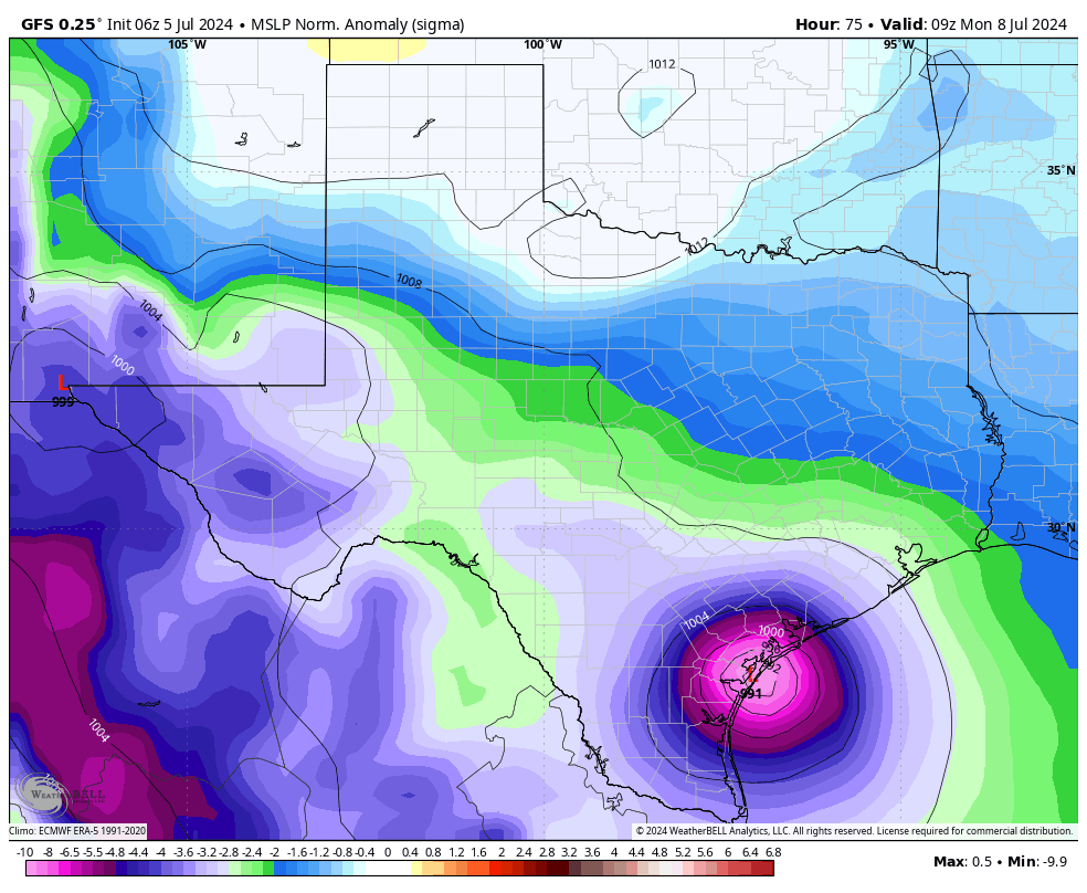
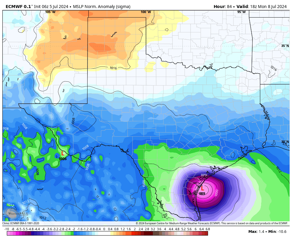
Beryl made landfall in the Yucatan Peninsula this morning, and will spend most of today traversing the Mexican peninsula before emerging into the Gulf of Mexico this evening or tonight, likely as a strong tropical storm. The storm will then have about two days, or a little longer, to re-strengthen over the Gulf of Mexico before making a final landfall late on Sunday night or, more probably, Monday.
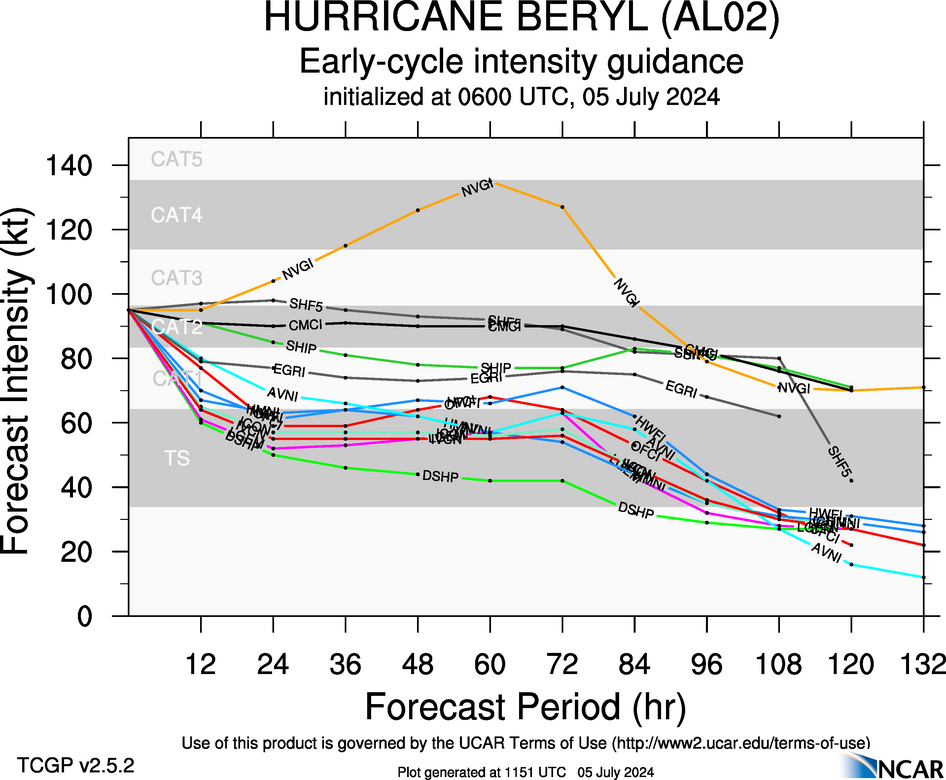
Given that Beryl will have plenty of time over the Gulf, it is likely that the storm intensifies back into a hurricane. Nearly all of our guidance shows the system remaining a Category 1 hurricane as it nears the Texas coast, but certainly we cannot rule out a slightly stronger storm.
Houston impacts
At this time the Houston area is still unlikely to see severe impacts from Beryl, but obviously we are watching the situation closely due to the evolving track. I would anticipate about a 20 percent chance of Galveston experiencing tropical-storm force winds on Sunday or Monday, with lesser odds for inland areas. In terms of storm surge, at this point Beryl should remain far enough south to preclude a significant surge into Galveston Island and Galveston Bay. We are talking tides maybe a few feet higher than normal, not dissimilar to the effects of Tropical Storm Alberto a couple of weeks ago. Obviously we’ll monitor this closely.
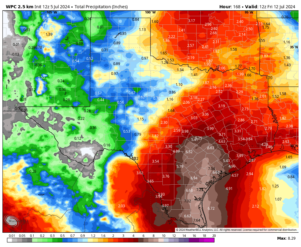
What hasn’t changed much is the precipitation forecast. Much of the Houston area is still likely to see 2 to 4 inches of rainfall over the coming week. Our concern remains the potential for higher bullseyes, driven the tropical nature of rainfall from Beryl, on Monday, Tuesday, and Wednesday. That is something we have not had great confidence in predicting, and still don’t. But the bottom line is that there remains no signal for major flooding in the Houston area at this time.
Final thoughts
I realize some readers will be disconcerted by the changes in Beryl’s track. It has been a surprising move, but not one out of the realm of probability, and this is ultimately the nature of tropical weather. Matt and I don’t think there’s a great chance that Beryl comes inland into Texas north of Corpus Christi. But is there a chance that could happen? Yes. It is certainly higher than it was on Thursday when we looked at the data. We are at the point where the greater Houston region, including Galveston Island, should be wary of Beryl, but not overly worried. Expect multiple updates today to keep you as best informed as possible.

Arrrgh… ANOTHER revised track further to the NORTH. Just when I was going to put my paranoia back in the fridge for another week.
Maybe we need a new model to forecast the number of model revisions?
Blackhawks: I don’t think we need a new model. All that will do is add more freakout energy to those here who are already freaking out with the current data provided. (And, freaking out over a barely Category 1 is not worth it.)
A new model would just lead to more “paralysis by analysis”.
Oh, I’m not freaking out over a barely Cat 1. I’m freaking out over the barely Cat 1 which becomes a Cat 3 or 4 in less than 24 hours.
Great fridge trick, Blackhawks.
I’m concerned about its fuel consumption too if it goes more N.
I read a comment yesterday (here on SCW) where the perso6 mentioned the “Ventusky” weather app. I was curious about it, so did a search about 30 minutes ago this AM – turns out they have a website too. Obviously, Euro based.
.
Anyway, I entered our zip code and it moved appropriately. Guess what – it shows Beryl turning and heading towards Galveston and Houston. I have no idea what models Ventusky based its predictions on.
I’m wondering too…
ICON, I believe.
Yes, ICON from WeatherNerds.
Probably selected to maximize app downloads?
It depends but usually is ICON. Now I am not the most knowledgeable since I began using it just last month. But there should be hamburger menu at the top right corner. Go to “settings” and you can change the model. It is usually on Automatic but you should be able to change.
Seeing as how the parental unit – who is extraordinarily worried over these things, esp since Harvey – lives in Katy … Should Katy Evacuate turns into a real question here. That the storm keeps doing unexpected things is not helping matters here. #end vent – just had to say it out loud.
Ugh.
why would katy need to evacuate and not the rest of the area?? I’ve only lived here a couple years and don’t know the area that well, but that doesn’t make sense to me, especially being so far inland.
As Katrina showed forecasts when distance of NO to Key West, or TX to Yucatan so about 3 days can shift 150 miles the width of Louisiana. So like 20 degrees at 3 days. So one can sorta eyeball it . But helpful rules are: rarely do they shift left from straight path line, rarely lose enough orbital momentum to suddenly veer far right and just they move north at surprising speed thus changing landfall if coast is diagonal, and only big ones can veer more as they tap distance low pressure. I could be wrong.
I agree, maybe we need better modeling technology to work with..Based on what I’ve been hearing officially, I decided not to worry so much, and to go on with my plans to have my granddaughter here for the weekend, she lives an hour and a half away..We pick her up and take her back to the Cypress area Saturday or Sunday, depending on which day has a greater likelihood of drier roads..
I’m reading from this forecast , to go ahead with my plans, vs cancelling them and making hotel reservations for evacuating somewhere up north..Being on a fixed income, I have to be sufficiently alarmed enough to go ahead and make the reservations for a multiple day hotel stay…But I darned sure don’t want to be scrambling at the last minute with a cat 3 or stronger knocking at my door either..
If Beryl follows the current track, what do the affects look like for the Austin area next week? (I’m due to drive up from Houston Tuesday afternoon.)
For Austin? I would say much needed rain.
Thank you for keeping us posted 🙏🏽
-Galveston
Should Katie evacuate?
Not local are you?
Katy *
Whoosh.
Maybe you mean Katherine?
I already kicked her out. She’s at her mom’s house now.
Can we reassure relatives new to inland TX by saying past 40 miles inland the wind and flooding of any H is not destructive? Austin is safe. Conroe is safe. Only bozos like me who traded risk for ocean need live in fear.
I mean tornados and power outages and flooding still happen…
Those events happen anywhere, it’s a normal risk of life, IMO….Those who live in hurricane prone areas, wildfire prone areas, etc, are shouldering an extra risk, because they like the area where they live, so for a time, they’ll deal with the tradeoff..
What with hurricanes taking days or weeks to arrive at a certain location, there is plenty of advance warning, so that is a positive thing….
I just feel like the computer modeling systems are becoming more and more archaic, thus affecting the quality of our data..And nothing is being done about it by governments to help the weather experts..I’m likely wrong, and it’s my paranoia and frustration speaking…At least I hope I’m wrong..
Lake Charles is about 30 miles inland from the Louisiana coast. https://youtu.be/vqgnVkj-BFM?si=gLN8SpHCxDHtKiQB
That isn’t true at all. Just look at the power outages caused by wind in Ike around Houston, or the flooding from Harvey deep in Texas (La Grange, Austin, etc.) or the tornadoes in NW Houston during Harvey. The only thing being 40 miles inland is going to get you is a lack of storm surge (which is the most destructive thing in a Hurricane).
In N Houston the hi H winds never got us. We lived up high. So yes past 40 miles it’s dishonest to say a H is coming and may ruin an inland house up high. Harvey was once a century stall too, I’m talking avg H just won’t ruin houses on small hill past 40 miles.. It’s why it’s smart to live inland, let’s admit that, y’all are mostly safe in Austin and Conroe, right????? In Dickinson by Galveston we had third of houses flood, that’s a catastrophe, that’ll not happen to Conroe. 40 MILES INLAND IF NOT LOW LYING A HOUSE IS SAFE, LETS NOT SCARE FOR FUN THE INLAND OLD.
I agree. 40-50 miles is a long way from the coast. Cat 1 is just not that bad.
Native Houstonian here.
Houston one could say IS JUST 20 MILES INLAND due to Trinity Bay bringing flat ocean water up north to LaPorte. New Orleans sorta has this too. So the 40 mile safe rule I think is valid!!! 40 miles from closest salty water, LaPorte. Hmmm. Past 40 it’s freak thunderstorm winds to fear, which are rarer risk. At coast yearly 5% yearly risk maybe, 1 in 20, inland freak storm blowing off roof 0.1%, 1 in 1000 which is still scary hi.
I’m also a native Houstonian and agree with you!
Over the years I have noticed that the models have a western bias to them. They seem to miss storms turning to the north and east. Rita and Ike were two of many storms that were forecasted to move to our southwest and ended up making the northeast turn. I am assuming it is because the models fail to pick up a weakness in the high pressure over the south that tends to keep them moving west. In any case I am leery of any storm forecasted to make landfall to our southwest. Which is why I kind of cringed when I saw the “were not really concerned about Beryl and Texas” headline on July 1st.
I don’t fault meteorologists for not being able to parse shifting and inconclusive data several days out. I do judge them for making conclusive statements about such (‘we’re not really concerned’) when the storm is several days out and it’s been repeatedly shown that storms (hurricanes in particular) can’t be predicted more than 3 days out….if that. It’s an unforced error. Honestly, it would be better if meteorologists just limited themselves to immediate short-range hurricane forecasting. Or just admit they don’t know and can’t know. Would it be frustrating for the professionals and anxiety inducing for the readership? Yes. But it would be truthful, and it would prevent situations when the truth of the inaccuracy comes out and trust and reputations are needlessly dinged.
Predicting the future of a chaotic system like our atmosphere is difficult to say the least. I think SWC does a great job of avoiding hyping storms like this in a shameless grab for “clicks”. The reality is they can’t limit themselves to immediate short-range hurricane forecasting. Nobody would visit the site. I think it was a poor choice of words to use that headline on July 1st but they have a tough job and have to post something.
Exactly. This. Born and raised in coastal Tx, a lifetime spent here will teach u to pay attention to the ones forecasted for N Mex/S Tx; forecasts for Mid/Upper Tx coast many times slide up into Lake Charles/New Orleans.
I think the better way to describe this is the model have a hard time seeing the weather patterns that lead to these N/NW turns. In the case of Beryl this is being driven by the weakening of the high pressure over Florida (which was driving it west) by the trough over the Midwest and a second reinforcing trough this weekend. The models struggle to predict the timing and details of these complex interactions in the mid-level steering. We’ve know for days this was possible. That is why the cone of uncertainty exists….and it’s had the southern Texas coast in there for days now.
I understand that, however you’re referencing storms from 20 years ago. The forecasting accuracy in short range models has gotten MUCH better in the past few years.
I lived in H town during Rita, We barley got any rain from Rita. It hit the Tx – La line.
I suspect simply 1) assuming straight path plus 2) adding tiny coriolis tendency per mile to clockwise veer (due to curvature of earth so a rock solid and easy factor), would get darn good prediction. Thus forecast is often NOT really about high and low pressure especially for smaller hurricanes. Most smaller hurricanes are boring long flat curves, from just 1 and 2?
We went from not being concerned about Beryl and Texas to it’s definitely making landfall in Texas and is just a matter of where. And now seems like it’s heading towards our area. Everyday it’s just a little more off from projection. Can’t really rely on the forecast unfortunately.
Yeah, my frustration…When will we know? When it’s too late to flee? I’m on a fixed income and not wealthy enough to book a room up north and go to a hotel today or tomorrow, and wait days to see how this unfolds..On the other hand I don’t want to be on the roads hightailing it to a shelter with this storm nipping at my heels…I would love to know 2 or 3 days ahead of time if this thing was highly probable to hit close to Galveston…
Katrina 2005 they shifted forecast 200 miles about 2.5 days ahead. Corpus is 200 miles from Houston and it’ll hit in 3 days, but forecasting is better now. Save money for hotel in August when risk of Storm X isn’t 1% but 30% or 50%.
I am SO sick of this stupid climate. I cannot wait to move in a few months. That is the only thing keeping me sane right now.
Adam, I would like to recommend a relocation destination of Fargo, ND. You will like it there, especially in January…
You joke, but I LOVE the cold and snow.
and you’d also get spring floods in Fargo!
Bye! Don’t forget to leave a bad review!
I don’t think he’s blasting awesome Matt and Eric..My take is that he’s frustrated with our climate and how our current guidance technology deals with these storms
Exactly. If I were new to Houston, the past two years would frustrate me too
Good bye 👋
Adam, we’re all happy to see you go! Byeeeeeeee!!!
Call it oldtimer’s superstition, but Hurricane Carla was my first one in 1961 and we were on the dirty side of it, as it went in south of us at Port O’Connor (near Corpus). And I’m begining to feel some Carla vibes. The dirty side is no joke, there were then and can be a LOT of tornados, wind and water. My husband was 9 and his entire family and their frame house was picked up by a tornado in Greens Bayou for a few seconds, a la Wizard of Oz. I hope everyone stays alert over the weekend and thanks for keeping us updated!
This northward trend has been talked about for days. Weatherbell sniffed it out long ago. You guys are late to the party.
Good news actually. Having to water outdoor plants/grass is silliness in humid subtropical – a good set of rain days is welcome. Maybe notch that first 100F today (at Hobby). The weekend after this one will be scorching and unusually so. Note chance of a damaging tropical bullseye at any given location is hugely remote. So y’all relax (except if you live right on the coast – how do you afford insurance) and most here should have an NFP policy.
Yes! This tropical rain will be fantastic for the grass, plants, animals, trees and lakes! Everyone needs to calm down, just like Taylor says.
Gentlemen:
Your analysis and candor are greatly appreciated.
The trend north has been consistent over the last few days. Is there any reason to believe it will NOT continue to trend north? Possibly even North or Northeast? Being a few days it looks like it could make a big turn
It is possible. The 7AM CDT track now shows the 5 day cone of uncertainty at the Texas/Louisiana border on the east side. There is some signal that a continued turn to the NE is possible. But there are a lot of dynamics at play here (where the storm comes off the Yucatan, how fast the ridge over Florida slackens, how the trough over the Mid-West builds and gets reinforced this weekend, how much strength the storm can build over the Gulf, etc.).
Remember also, that if it turns NE that means landfall is likely delayed some, but it means it has more time to strengthen over warm Gulf waters. As Eric says, pay attention as this develops. A lot depends on how it looks coming off the Yucatan (location, strength).
I think the answer to your question is answered by the speed and strength of the storm. A stronger, slower moving storm is more likely to get caught up in the high pressure weakness and move north and east
On a positive note. 2-4 inches of rain and a few cloudy rain cooled days in July is just what the Dr. ordered!!
Maybe the cone of uncertainly needs to be widened for 3+ days out. Millions of dollars are being spent on these models, but the number of variables and how to weight them is extraordinary.
Three days provides time to make rational decisions, as long as you have a plan. My bigger worry about this one is flash floods in the Hill Country, but they do need the rain……Maybe Lake Travis will fill again!
Some of the comments want something of a time machine to get a 100% accurate weather forecast which is impossible to do with our current technology. Next its gonna be lets predict an earthquakes location 3 days in advance
At a guess the govt cone seems to be 5% risk.
They don’t want poor people using last money to flee every year from hurricane which actually on avg will only hit them 1 in 10 years. If you sit in hotel room for 10 times for nothing youd start to ignore cone. Or is the cone 20%? They should tell us.
Not the news I wanted to wake up to, that’s certain. And I agree with a some that the verbiage used here in the last few days was too disarming.
I think that Space City Weather really needs to reevaluate the way they phrase things ON HERE.
Nah, it wasn’t a concern then. Now it is. If you personally need more than 2 days to react to something 2-3 days out, that’s a you problem.
It’s hurricane season. It starts June 1 every year. You live in an area that can be hot by hurricanes. You should be stocking and prepping when the season starts, not “the day” the storm arrives
(Use of You here is the royal you)
Tyrus is perfectly on point! Well said.
No doubt Beryl has been a prize fighter and defied all guidance…especially intensity…which is the hardest to get a grasp on anyways. I’m curious how much AI has truly been incorporated into overall forecasting. Maybe it’s just me…but ever since AI was made public per se…the overall guidance performance has been a little off cue. Again…maybe just me.
Beryl has barely shifted, a 60 mile shift of landfall 4 days out is not major. I think smaller hurricanes go in straight w right veer and rarely surprise. Look on a map, it’s been straight w constant veer (the veer is from Coriolis, as you head towards North Pole the wind literally feels urge to head east due to momentum as circumference of planet narrows, so this is lock solid part of path one can count on). Katrina in 2005 they jumped the forecast 200 miles at 2.5 days from landfall, but we have better tech now, probably 100 mile left or right is new window of worry. I could be wrong.
Eric thanks for the constant updates and dealing with a dynamic, evolving situation. You and Matt do a phenomenal job communicating what is essentially changing conditions from hour to hour more than a week out and you guys do it as a side job!! Much appreciation for all the aspects you deal with and I can’t imagine living in Houston without SCW to keep me informed about the ever changing weather.
I see that the northern GoM is now running about 30 degrees C, similar to the temperatures that intensified Otis. Thoughts on intensity predictions – I know they are dicey.
10am NOAA shifted track north. This one’s a creeper. Katy bar the door!!
I just read the Cone is where 51% likely the storm stays within cone bounds. They fudge a bit and most think it’s 67%. But still I thought it was 90%. Wow. I feel less safe here in Houston. 67% cone????????
It’d help to see thru 100 examples how good is the 3 day cone forecast. It seems usually cone is very correct at 3. But Katrina was 200 miles off at 2.5 days in 2005. And “””Hurricane Marco in 2020, the center of the storm tracked outside of the cone originally issued five days before its approach to the Gulf Coast.'””. How reliable is cone?
Thanks for the update, guys! Going to fill up my car and get a little extra food just to be safe.
The 10AM National Weather Service track is shifted north of their 7AM track, but their track still has the storm making landfall south of Corpus Christi. Seems to me that NWS is always cautious when they shift their track, so maybe they are catching up to the latest model guidance that has it hitting Corpus. Anyway, Houston is inside the cone of uncertainty. I don’t like this.