In brief: So far Beryl hasn’t strengthened much today, but there is yet time for intensification before a final landfall tonight. This post goes into the likelihood of such intensification and what it would mean for Houston in terms of winds and the potential for power outages. We also look at the latest rain and surge forecasts.
Beryl status at 4 pm CT
As of this afternoon Beryl remains a tropical storm with 65 mph winds. Its central pressure has dropped a bit to 988 mb, indication a trend toward better organization. The storm is moving to the north-northwest at 12 mph and remains on course to make landfall near Matagorda between midnight and 4 am CT on Monday.
Intensity and track outlook
The fact that we’re not seeing significant increases in Beryl’s winds this afternoon is great news. The biggest threat to the greater Houston area from Beryl is damaging winds, and less intensification means less damage once onshore.
Beryl is running out of time to strengthen—that is not a taunt, mind you. Please let the record show I did not taunt Beryl. The storm will move inland in 8 to 12 hours. There is still time, and the waters are very warm with atmospheric shear low. However, forecasters at the National Hurricane Center note the storm is still struggling to shrug off some dry air in its core. They are still calling for an 85-mph, Category 1 hurricane at landfall, with the likelihood of rapid intensification this evening. This certainly seems plausible, but I am rooting for that dry air to keep disrupting things for just a little while longer.
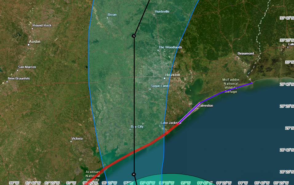
In terms of track there is very little change to the system. Beryl should come ashore early on Monday, and pass near Katy a little before noon before it lifts further out of the Houston area. This rapid forward movement should continue, allowing the worst effects to begin clearing out of the city during the afternoon hours.
What to expect, and when to expect it
Tropical-storm force winds should reach the coast, near Matagorda Bay, around sunset on Sunday and push into Galveston Island a few hours later. The stronger winds will move into much of the rest of the metro area just before or after midnight tonight. The heaviest rains will arrive around the same time. Please find shelter a few hours before this.
How bad will the winds get?
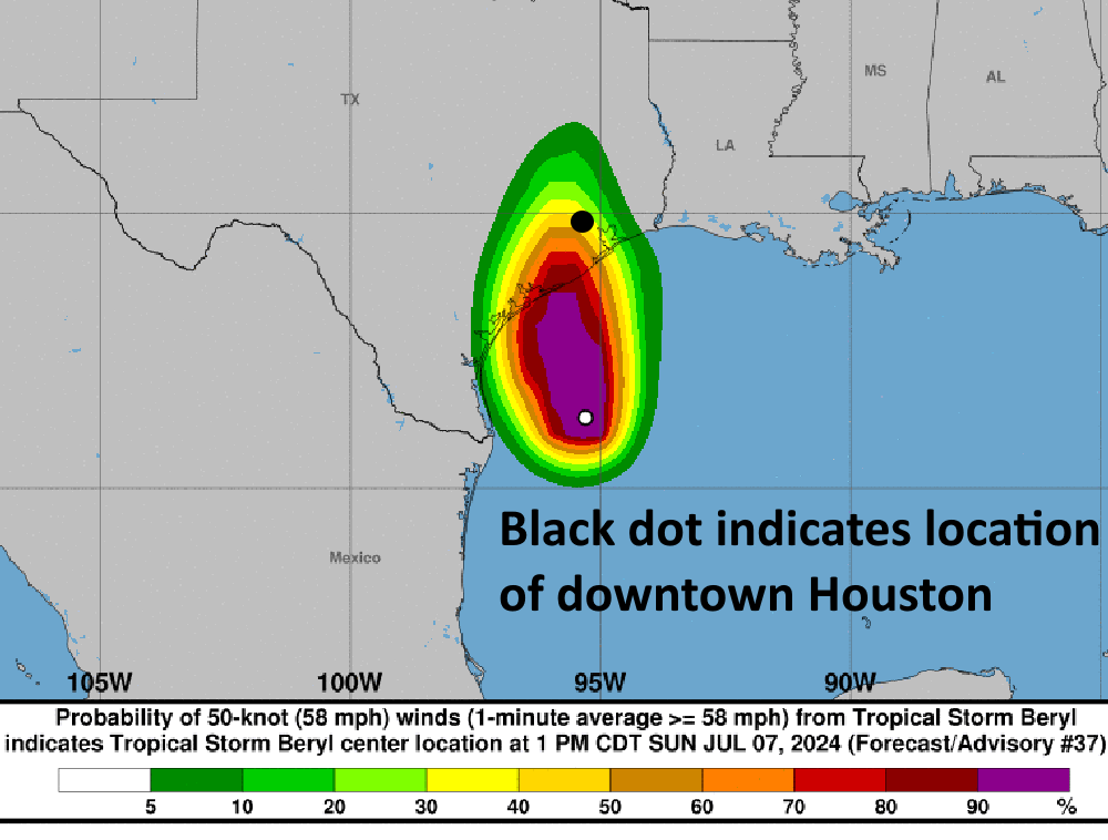
For this outlook I am going to focus on the possibility of seeing sustained winds of 60 mph or greater, which is likely near the threshold for widespread power outages. The map below shows the National Hurricane Center forecast for the probability of winds of 58 mph or greater from Beryl. I’ve annotated it with circle that roughly denotes Loop 610. Winds at this speed likely will not cause roof damage (that threshold is higher, perhaps 70 to 90 mph sustained winds). The map clearly shows the risk for damaging winds and power outages is greatest to the southwest of Houston:
Several readers have asked about tornadoes. Yes, they’re possible within the rainbands of Beryl tonight and on Monday morning. However I expect their development to be fairly scattered, and the bigger threat for a majority of people will be winds directly related to Beryl’s circulation.
Some thoughts on power outages
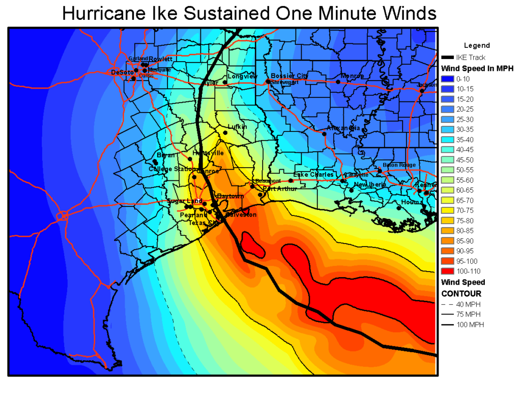
I’ve spent a couple of hours today doing some digging to try and set some expectations for power outages tonight and later on Monday as the core of Beryl’s winds move into the greater Houston area. Our most recent tropical system with a major “wind” component was Hurricane Ike, a Category 2 storm that made landfall in 2008. It came ashore about 90 miles further east than where we expect Beryl, but it was a much larger and more powerful hurricane. Here is what Ike’s sustained winds looked like.
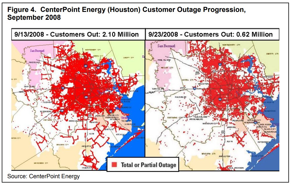
Ike knocked out power to 2.1 million CenterPoint Energy customers in Houston, and 10 days later the power remained out for about one-third of these customers. I want to be clear, I do not think Beryl will have this magnitude of an effect. Far from it, likely. But it’s useful to study the map of outages below and see where there were fewer problems (i.e. northwest Houston).
My back-of-the-envelope estimate here is that widespread power outages start to become more likely at sustained wind speeds of about 60 mph. The majority of Houston will probably less than this tonight, although such winds are likely in many areas of Brazoria, Fort Bend, and Matagorda counties. They are also possible west of Houston, in locations such as Katy.
My general expectation, therefore, is that power losses will be in the hundreds of thousands, and restorations in days; rather that losses above 1 million with a week or two of restoration. However that is a guess rather than a firm conviction, and given since so many people are understandably concerned about this issue.
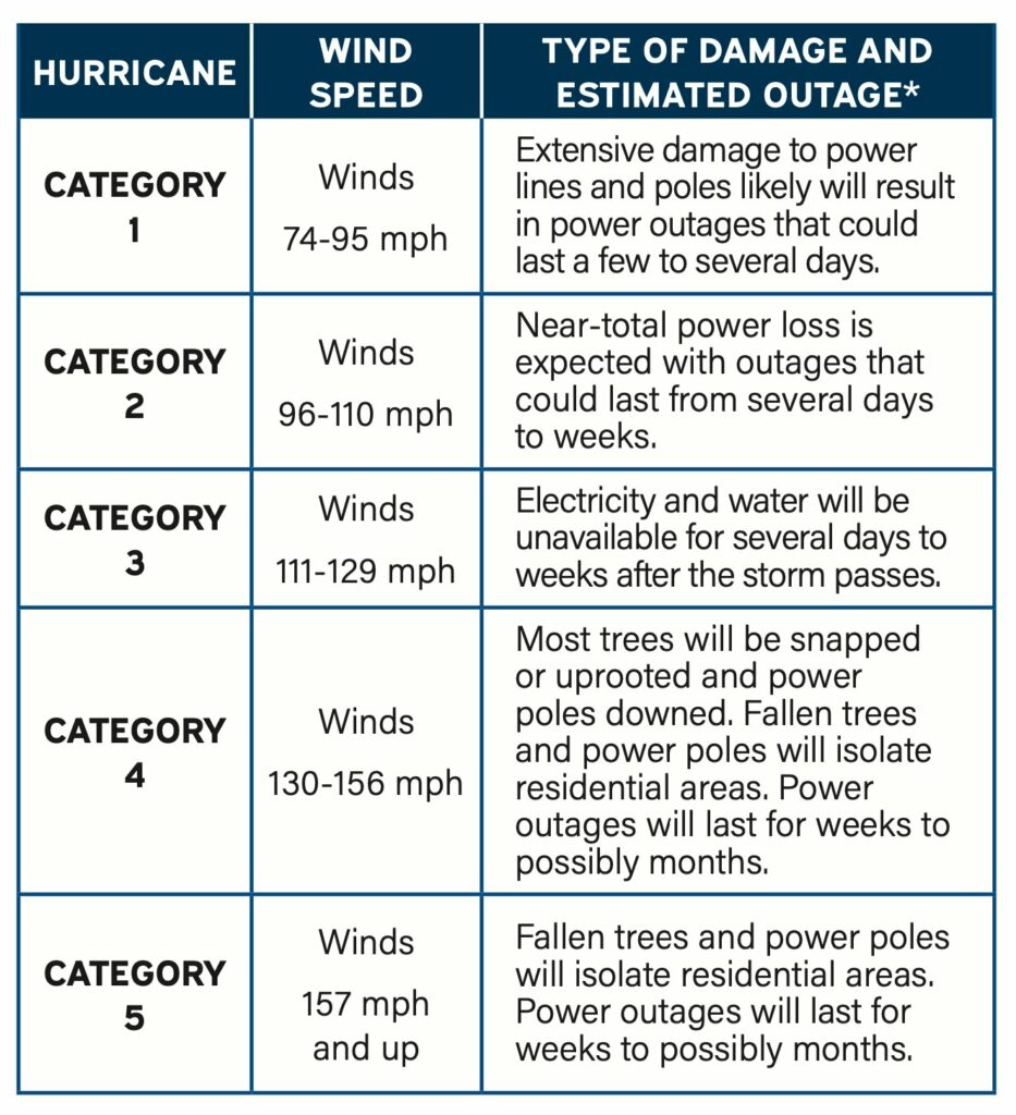
Finally, I very much do not expect hurricane-force sustained winds tonight in any part of the Houston metro area apart from the immediate coast near Matagorda, and possibly locations such as Freeport or Lake Jackson. For what it’s worth, CenterPoint’s estimate for Category 1 winds is: “extensive damage to power lines and poles likely will result in power outages that could last a few to several days.”
The bottom line is that power outages will be a wait-and-see game. Good luck. Charge those phones now, my friends.
Let’s talk rainfall totals
We’ve seen some fairly widespread shower and thunderstorm activity today as Beryl’s outer rainbands have moved onshore. So far, it’s been fine. I expect to see additional storms this afternoon and evening, but it should be mostly manageable.
The main event should arrive at the coast a few hours before midnight, and push into Houston around midnight. Based on the latest modeling the “thickest” rain band will likely move through the city around 4 to 8 am, bringing intense rains that will quickly flood streets. Conditions should start to improve during the late morning hours. However I would expect to see additional rain showers later on Monday night and Tuesday due to trailing bands (which won’t be as intense). In any case, this is another good reason to stay home from this evening through Monday morning.
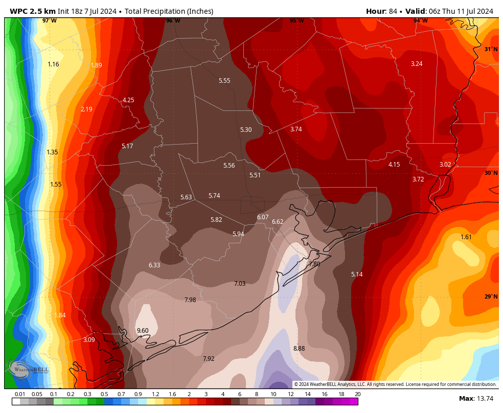
In terms of accumulations, it still looks like coastal areas face the highest risk, with totals of 5 to 10 inches likely, and accumulations further inland of perhaps 4 to 8 inches. What we’re most concerned about are more isolated areas that fall under the heaviest banding. These locations could see 10 or more inches of rainfall. It is impossible to predict precisely where these will set up, but the latest modeling is hinting at higher totals near Galveston Bay. We’ll see. We have a Stage 2 flood alert in place.
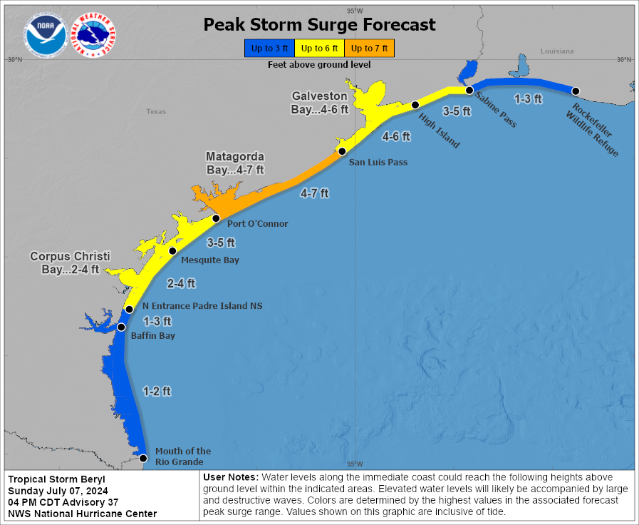
Storm surge
Peak storm surge levels, the combination of high tide and surge, should arrive on Monday morning the upper Texas coast. For Galveston Island and Galveston Bay, water levels are expected to be 4 to 6 feet above normal levels. Surge should be slightly higher in Matagorda Bay.
Final thoughts and plans for tonight
Beryl is on our doorstep, and its winds, rains, and waves will move into our area tonight. The key thing I’m watching over the next several hours is whether the storm starts intensifying, as a weaker Beryl will cause far fewer problems in Houston on Monday morning. As always, we will hope for the best and prepare for the worst. Please make plans to get home, or to a safe place this evening, and remain there through the morning hours on Monday.
Our next post will come around 10:30 pm CT tonight, and we’ll continue to post overnight and into Monday as this dynamic event develops.

Hmm… close to another Claudette?
Claudette was a massive rainmaker. I don’t see the parallel.
The one that hit Matagorda in 2003? About the same intensity, landfall, and wind…so I thought.
Sorry for the confusion. I think they’re different storms since Claudette was going due west at landfall and Beryl will be going about due north. So significantly different wind effects for Houston.
I think the OP is referring to Hurricane Claudette in 2003 that made landfall in Port O’Connor.
Ahh, my bad. The thing is the track of Claudette was almost due west at landfall, whereas Beryl is coming north bringing the center near Houston. So not really comparable in terms of winds I think.
Thanks for all your hard work.
So thankful for you guys- straight and not promising things you can’t promise. Will continue to live in the moments we have prepared for…
Thank you
You are so appreciated!!
Thank you for the detailed analysis and expert opinion!
I’m supposed to fly in to Houston tonight, likely landing at IAH around 10pm local time. The gate agent insists that our plane WILL go to Houston tonight because it must (for reasons unclear) which I hardly find reassuring. I’m not keen on waiting another two days to go home but this is nuts, right?
I think the gate attendant is probably right. Hope you make it in.
I’ll take your word for it, then! I’m expecting a very uncomfortable ride but it will be good to be home. Thanks for your response and all the work you’re putting in to keep us posted.
Update: Landed in Houston! Thanks again for easing my nerves. Hope everyone is safe out there, including those of you who got wrapped up in airport chaos today.
Hah, awesome. Congratulations.
My Wife’s flight from Vegas just got cancelled.
Or so she says… just kidding!! 🤪
You devil…..
Whatever happens in Vegas stays in Vegas.
5:30 pm, they issued a ground stop at both airports. Check with your gate attendant again.
Thanks ! Now Get some rest ! We appreciate your help.
Thank you as always for these detailed updates, Matt & Eric. You are truly appreciated!
Thank you for the update. Very helpful and appreciated.
I will ONLY take your updates seriously! You are so valued and appreciated! Thank you!
shout out to not only Matt and Eric but also the folks that keep the site available and running during high load times like these. Aannnd to their fams that would probably love to have all their members all huddled together instead of the one focused on the storm and reporting instead. thanks to all of you for what you do!
Thank you for yet another insightful update. You guys are certainly putting in the OT these past couple of months and we do want to say how much you are appreciated. Thank you so very much.
Seconded, yall are really putting the work in lately and we so appreciate it 🙌
Thank you so much for giving us quality information and non-hype predictions about this. I hate how network news and other major media outlets only want to sensationalize every aspect of weather and induce panic, just so eyeballs will remain glued to the news reports. Your approach is true news and information, not to soothe everyone or spread fear — just to inform and give reason-based predictions about what can happen. Thank you so much!
Thanks for the taunt joke and for the no-hype approach, which helped settle the nerves. Good luck to us all!
Thank you! I only listen to what yall say… ready to see ur next update.
Thanks for all you do!!
Thank you for all you do to keep us informed.
Isn’t Beryl very similar to Hurricane Nicholas? I ask because I’m wondering why you compared Beryl’s effects to Ike instead of Nicholas.
As always, thank you for the long hours you all put in this time of year!!!
The thing is, for some of us, Nicholas had almost no effect on us. I don’t remember the track of Nicholas but I think it must have been different. I live in the northwest side and all we got were some regular t-storms, no bad wind at all. Beryl looks to be more intense for us, even if it stays a TS.
Nicholas moved west to east along the immediate coast. It didn’t move through the Houston area. Nicholas was also not as strong as Beryl is going to be. The max sustained winds in Nicholas were 75mph while Beryl might get up to 85mph. Nicholas was rough for Matagorda and Brazoria Counties but the impacts in Houston were pretty small I believe.
It moved through the League City area all right! That’s where I am, which is why I’m wondering how Beryl will compare. But good point: I didn’t realize most of Houston didn’t get much from Nicholas.
Hi, do you expect any heavy sustained winds and rain in the 77007 area (Memorial Park area)? We were impacted heavily by the May storms and had roof damage but those were apparently 100+ mph winds
I expect both heavy rains and high winds there, but certainly not 100+ mph winds.
Thanks for your detailed and non-hysterical analysis. One of the broadcast channels is raising the possibility of “another Alicia.”
Given that Alicia had 115 mph winds at landfall, that certainly seems unlikely.
Seriously, after all these years and Katy is finally threatened???
Feels like a capstone moment on my career. (Not that I’m going anywhere).
Obviously Katy completely evacuated 48 hours ago, there’s simply no one left in town to even ask the question.
Nah, there are a lot of sitting here in Katy still. Katy got hit fairly hard during Harvey, too. Lots of flooding here.
I’m a 20 yearHouston transplant from Ga, and I loathe the weather here. But your weather updates get me through these storms and power outages without completely spiking my blood pressure and/or making me want to load my boys and dogs in my car and never look back (bye, husband). With gratitude and appreciation,
I’d love to also be able to do something about summers here, but alas we’ve got nothing for that.
I’m curious about the water temperature in the gulf and the wave action effect’s on the water temperature. One would think that the temperature would start to drop as the deeper water gets mixed with the warmer water?
It will help some, but I expect by the time the next storm gets into the Gulf it probably will have all mixed out.
That’s an interesting question. How much upwelling would a hurricane generate and how long would the change in temperature last? I don’t imagine it would last long. The Gulf is relatively shallow and the Sun is the undisputed, and undefeated champion of the thermal realm. I’d imagine it’d be less than a week before it returns to normal levels.
Holding off on all my Katy references and jokes
Stay safe, everyone.
Huge thanks to Eric, Matt, and Dwight for everything! SCW is greatly appreciated, especially at times like this.
Thanks for the great job. As a 71-yr-old native Houston, I’ve slogged thru a few weather-related hissy fits. Also, I vote you keep using the black dot for downtown Houston on the maps. Helps these old eyes keep the geography accurate.
Oops ….. Houstonian
As usual, superb job! 😂 But I think I’ll scratch one word off that SCW teeshirt I bought that says, “Heat, Humidity, HURRICANES, No Hype”
Rooting for that dry air!
Thank y’all so much!!! We really appreciate you SCW!!!
Since my predictions are always wrong, allow me to publicly predict a category 2 hurricane knocking out power to millions. Anyway, I have stocked up on plenty of provisions from Spec’s.
Eric thanks. You have done your best. Now we ride it out and bounce back.
You’re using ie incorrectly on your stage 2 graphic, it should be eg
Thank you! I work at a grocery store, and lemme tell what it was like today. Uh. I’m tired. LOL at any rate, I have severe Ike PTSD as that one (and Allison) was bad for me personally, and despite being a native Houstonian, I’m never used to this stuff. Some days I miss the time I experienced the Northridge earthquake in 1994 in Orange County in an apartment on stilts. Then again…
What are your thoughts about winds and power outages chances in The Woodlands?
I fly out tomorrow from IAH at 3pm – going to Raleigh, NC. United airlines has opened check in as normal, no impact so far.
What are your thoughts as Beryl makes its way north towards Tyler?
At Dwight’s suggestion, I downloaded Windy and am a bit confused. Their forecast tracking has better resolution than I get from sites like Tropical Tidbits.
If you wouldn’t mind including a note in the 10:30 post, I’m curious to get your thoughts on:
1) How much credence you give Windy’s tracking. They show the NHC tracking the storm right through more than a few rather populated neighborhoods.
2) Your thoughts on the accuracy of NHC vs the UK vs Europe as of late. It’s been interesting watching them all wobble around, and I’ve been a bit lazy this year and let my scorecard get a little out of date.
Perhaps this storm will cool down and churn up the Gulf a bit and take the edge off the fuel for the stream of storms that will haunt us for months
You’re incredible for always doing this for all of us. Cheers, good sir
THANK YOU SOOOOOOOO MUCH FOR YOUR INFORMATION! YOU ARE APPRECIATED. AFTER 30 YEAR LIVING IN SHARPSTOWN AREA, IT IS A BLESSING TO HAVE YOU SHARE YOUR KNOWLEDGE REGARDING UPCOMING WEATHER SITUATIONS. AMEN!
The local stations are basically good for just the visuals. Stupid comments like “another Alicia” only reinforce that view. The “kill shot” for me with all these playas had to be Blake Mathews calling for “blizzard like” conditions in downtown Houston during 2021 event. Turrible….
Maybe it’s just wishful thinking, but I am hoping that the recent “derecho” storm brought down a large amount of the dead trees and branches that had not been pruned, so there will be less damage to the power infrastructure with this storm. The majority of outages are typically local in nature from falling branches. Sometimes they will shut off power to an entire area if there are many local outages for safety reasons until the crews can get in an area after the storm has passed. Having major transmission towers fail is extremely rare. As with any storms conditions and impact can vary greatly even in close proximity, so everyone should be on alert and prepared.
Many thanks for being the place Houstonians can trust when the weather gets scary.
Thank you, Eric. Be safe, everyone.
Again, many thanks to Eric and Matt. I’ve been a follower since Day 1 of SCW.
I would like to know your thoughts on what you think we should expect in Baytown? Also, any thoughts on the bayous?
I live just outside the Northeast corner of the County Houston is in – about 2 miles out of City Limits. We ALWAYS lose power out here if somebody in Houston burps and, mostly, are last to recover. There is, obviously, something weaker about the system that feeds our power than the other areas of Houston and the surrounding County. ( We have already had a Power outage out here a few days ago. )
Good luck to the rest of you and I hope you’re spared. Houston isn’t a place to be powerless – (and AC-less) in the summer. I know that because I was a Farm boy raised WITHOUT AC in a little town up near Dallas/Ft Worth which is even hotter.
I’m trying to find something that shows where the storm will be located hourly or every few hours. I’ve only found sites providing 6 hour updates. My problem is that I will be traveling home (south on US 59/69) from Arkansas Monday morning. I know I should stop for the night along the way, but I’m trying to figure out how far south I get before needing to stop. The earliest I can leave the Little Rock area is 9:30 AM.
I’m not sure there is one… at least not released for public consumption? Best of luck on your drive back.
Thank you guys for all your efforts to keep us informed without unnecessary hype. My nerves are stressed enough. Much appreciated
Thank you both so much for all you do. Your dedication to this and honest updates to keep us informed is second to none and so appreciated-Subscriber for life. Stay safe
Too bad Centerpoint can’t get your tech team to fix their outage tracker….
I was one of those laughing from inside the Loop back during Ike when people talked about Katy. Well, guess where I live now? Womp womp :-/
……….and pass near Katy a little before noon.
The stronger winds will move into much of the rest of the metro area just before or after midnight tonight.
I think I’m missing something.
I’m watching with interest from out of town…obviously, there’s not much I can do to prepare from here. Just hope my place fares OK and I don’t lose power, or at least not long enough to wreck the contents of my fridge. I’m in the city, not the coast, so…we’ll see.
Keep up the great work on your forecasting reports. You are the best
Reading your reports is essential to my feeling good about preparations Ive made for my family and friends. Thanks to the sacrifices you guys make to keep us aware of your detailed research. You guys are the best!
Do appreciate your sensible reporting and explaining. Thank You!
I recently subscribed to you updates.
Good luck everyone.
Farewell, Katy, it’s been nice knowing you.