Hurricane Beryl is now Tropical Storm Beryl as it lifts north across northwest Harris County this morning.

Beryl will make its exit to the north as we go through the next 2 to 3 hours. Conditions have improved south of Highway 59 and west of I-45, and that improvement will spread northward through mid afternoon.
Wind gusts: Most wind gusts are still on the order of 50 to 70 mph north of Houston under the stronger banding. Bush just reported 78 mph at 10:10 AM, while they peaked at 83 mph just a little earlier. Hobby maxed out at 84 mph before the sensor stopped transmitting data.
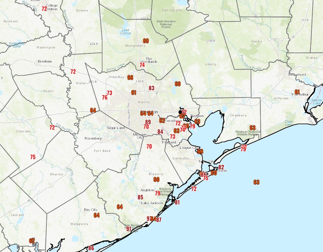
The highest reliable gust I have seen is 97 mph near Freeport at the gauge along the Brazos at highway 36. More reports will filter in, but suffice to say that 80 mph gusts are still a possibility north of Houston as this moves through. Even College Station managed to hit 56 mph with the top of Kyle Field reporting 90 mph (elevated winds will almost always be stronger).
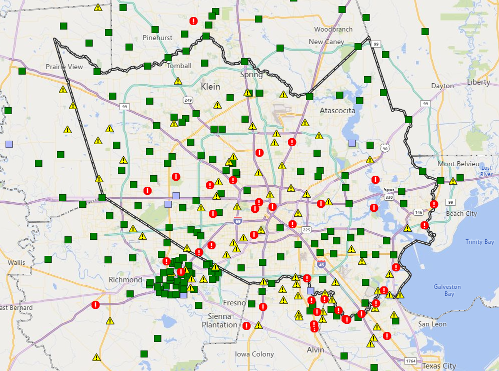
Power Outages: All we can tell you is that as of this writing, Centerpoint reports over 2 million customers without power. That’s more than the May derecho and roughly 50 to 60 percent of the region. It will take time to restore it. We have no idea how long. We know many of you are frustrated, and we’re just hoping for the best like you are.
Cell service: Many in the area are experiencing weak cell phone service. You may not have any cellular internet access, with just a bar or two, but still able to text and make phone calls. That’s because cell towers are subject to power outages as well, but they have backup electrical systems – either batteries or generators – to keep basic communications going. That may include batteries that last between 2-8 hours. Some carriers have trucks to service batteries or refill fuel-powered generators, but while the storm is raging they can’t move around the area – just as you can’t. – Dwight Silverman (Thank you, Dwight!)
Bayou flooding: Several bayous have come out of their banks across the region. We can’t possibly go through all of them, but per Jeff Lindner at Harris County Flood Control, Brays, Keegans (lower end), Clear Creek, Armand, Brickhouse Gully, White Oak (I-10 to Downtown), and Buffalo Bayou east of the Beltway were all being monitored. The Flood Control map is a great resource to check on bayou levels and rain totals. They also do inundation mapping which is useful if you live near a bayou and want to know how the bayous are trending.
Street flooding: As rain gradually tapers off, street flooding will ease up a bit. It will take longer than usual, however due to copious amounts of debris on area roads. Try to limit travel through afternoon if possible.
Tornadoes: We’ve had a handful of tornado warnings, but I am not sure if anything has yet been confirmed or likely confirmed. A tornado watch continues through late evening north and east of Houston into Louisiana.
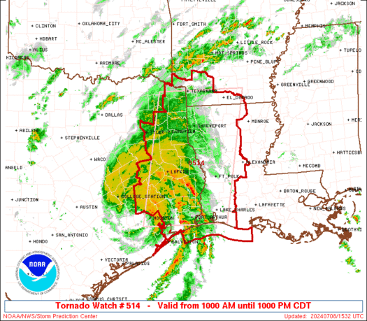
This watch box will likely be shaved down as we go through evening and Beryl moves out.
Beryl’s surprise: I saw a lot of comments from people that were surprised by Beryl’s wind. Admittedly, I was too. Beryl maintained hurricane status to I-10, which was a bit longer than expected I think, and the widespread wind gusts of 75 to 85 mph so far inland was really unnerving. Like the derecho and floods of the past, this will inform our coverage going forward. We will Monday morning quarterback the forecast plenty I am sure. Many of you already are, and justifiably so after any event like this. Look for more in the days ahead on what we saw and what we’re taking away from this.
Our next post will come sometime this afternoon. I’ve got a ceiling leak, a fence down, and two large limbs adjacent to my garage. Eric is dealing with no internet service (I’m sure many of you are as well). I can confirm both our generators are rolling, so we will be posting as in line with our schedule as possible. Thanks for your support and understanding, and we hope everyone is managing through this storm as safe and damage-free as is possible.
Thank you both for all you do for us!!
Thank you for the frequent updates.
Thank you a million for the updates and coverage. I can’t understand how people would complain about any of the information provided. I’m grateful for it. No hype, no nonsense weather approach. My family and I are traveling in from Mexico tomorrow as our flight was cancelled today. Thank you again for the updates.
Thank you, as always, for what you guys do. You were a lifeline during Harvey and remained my go-to source since then. Stay safe.
Easy to quarterback after the game is over! Thanks for your service to this city (and the region!)
We saw the model progression and this was always a possibility. Even a strong 1 is a hurricane! The only surprise should be what doesn’t happen!
Riding it out inside the loop! The winds are still a howlin!!
Thanks for all you do to keep us informed. It is greatly appreciated.
Thank you for all that you do! We rely on your excellent weather coverage and dedication!
You guys did a great job. No need to second guess. Good luck with your repairs!
We are so grateful for your service to the Houston and surrounding areas!
I have a question. I went outside around 5am and the rain smelled like the ocean or salt water, so I wondered…How much of this rain is salty ocean water and does it have an affect on the plants and grass? I’ve never paid attention after a hurricane to see if plants are affected.
My water softener sometimes has issues and when I water indoor plants it has killed them almost immediately and left the white salt powder on the soil. That’s when we know the softener was having an issue allowing salt water into the faucets.
Thank you Eric and Matt for your invaluable service to the community. We are very grateful.
Still have power and internet.
I should buy a Lottery ticket.
Me too
Interesting action here at I-10 west and beltway 8. The edge of the remnants of the eye structure seemed to skirt right by here. The rain stopped and it would be extremely calm and then suddenly some very strong gusts would hit and then it would get calm again. This has been going on since around 9:15a. It is much brighter out but still get some extremely strong gusts with big branches coming down. I was able to walk around outside for a few minutes before the winds got too bad again. Lots of trees and branches down. Power went out around 5:30a. 9.5” of rain in the last 24 hours. Buffalo bayou is up, but not to the level of the 2015 Memorial Day or 2016 Tax Day floods. And nowhere near Harvey. With the rain stopping the bayou appears to be cresting. Upstream at Barker Dam the water levels are low. Luckily Beryl was moving very fast. I hope all is well for everyone.
Same.
Half mile west of City Center on I-10.
Anticipated much more due to proximity of eyewall*.
Lots of trees got a solid shaking, foliage everywhere, but am stunned that we never lost power.
*not complaining
Thank you all at SCW. Stay safe!
Thank you!! Please stay safe.
Thanks, Matt. Ya’ll did a great job with a booger of a storm to forecast over the past 10 days. The winds I was hearing in Timbergrove at 4 a.m. made me think “the power can’t stay on.” It went off shortly after that. Ha. Not sure what our restoration will be here. Nearly every tree that was in trouble was felled in the derecho and CP cut trees out of lines while they were doing restoration work. Here’s hoping for the best for all my Houstonians!
Baytown is still getting really bad wind gusts, just in different direction. Praying they stop soon!
Thank you. Be safe!
Thank you so much for the informed reporting you do! I don’t trust anyone else for these forecasts.
Thanks to you both, Matt and Eric! I’m in Briargrove and the wind caught me a bit by surprise with how strong the gusts are and how long it’s lasted. Definitely treating this as a dress rehearsal for potential August/September storms.
I know modeling this one was tough. Do rising surface water temperatures skew the models y’all use? Was wondering if climate change is shifting the sands the models were built on.
Heavy winds in the TMC area. the Bayou is getting filled up , almost to the brim. No rain at this moment at 11.16am
Appreciate the work you spend on this. If you are Monday morning q-bing two thoughts to consider: Never again try to estimate power outages. Or get someone from center point who might estimate ( but I doubt it) assuming various scenarios. It’s a high risk low reward guesstimate akin to trying to back of the envelope airplane flight cancellations. Also, consider that in an effort to eliminate “hype” there is always the risk of underselling potential risks that deserve mentioning…even stressing. The potential for a developing storm to maintain its intensity far inland was never really stressed and this is what has likely created the somewhat unexpected higher wind and rain totals.
While I agree somewhat on avoiding predicting power outages moving forward, it seems that everyone was caught by the storm maintaining strength for as long as it did after landfall. The NHC prediction was for TS by the time it got to Houston, and the KHOU meteorologists this morning were also commenting on how unexpected it was that it was still a hurricane when it reached the area.
And to add context, I grew up here and it has always been accepted as fact that hurricanes will lose intensity by the time they hit Houston. So Beryl just taught us that this isn’t necessarily true.
So true.
Hi, Jeff.
It’s worth noting that, in the post where Eric dove into power outage issues, he was working from CenterPoint’s own chart, based on windspeed, which he included. So, in essence, he did get “someone from CenterPoint”.
Thank you, Dwight.
Saved me the typing.
Thank you for all the updates. Looks a little lighter here(Friendswood)but winds are still strong.
Thank you for the effort you and Eric put into this, and thanks to Dwight Silverman for the info he provided. I never considered that cell towers would have backup batteries, so that’s good to know.
Just wanted to say thank you for such great weather reporting! I’m interning here in Houston for the summer and was super nervous when I heard about the hurricane (I’m from the Midwest), but your incredibly level weather reporting that explained each of the concerns and updates along the way have eased so many of my nerves. Thank you!
Thank you Eric and Matt for your service.
You guys are the best! Thank you for the valuable information
Thank you for all the updates….Beryl has had a mind of her own from the very beginning and we all know one little hiccup can change everything expected about a storm in the blink of an eye…My main concern is that this was a minor storm despite all the damage it has done and we still have 4 months with August and September being our “historic” peak months…I pray that we don’t have something more powerful awaiting us…
Cypress Creek near Champions peaked around 30 minutes ago. It was over the road at the time. I happened to be there when it started to recede and the roads are passable now around here over the creek. We had 8 inches of rain at my house.
Thank you guys for all you do!
Though I’ve got 3ft+ of water in my house and the whole downstairs is destroyed. Maybe we bump the scale up to Stage 3?
Thank you for keeping us so well-informed while also dealing with the same challenges we are (loss of power, no internet, house/property damage, etc)!! Houston is grateful for you!
Much gratitude to Matt & Eric for all the valuable updates. Y’all are the BEST!
Y’all are awesome! Thanks for keeping us informed. Stay safe.
Thank you so much for your guidance through storms. Very grateful.
Thank you for the great updates.
Take care of yourselves, too!
Glad you are safe and no too inconvenienced. Thanks for your updates, as always.
Thank you from the bottom of my heart for all the information and all that you guys do for us. Your information is what keeps me sane and away from all the other news. I hope your families and properties are ok.
I can’t thank you guys enough for all you do to keep our community informed and safe, even in the midst of your own personal issues resulting from the storm. I know how hard it is to prioritize and your efforts are very much appreciated.
For the quarterback questionnaire… the first band that came thru yday morning was full of thunder and lightning. But there didn’t seem to be any light show with the main storm…? Did I miss it, or are there Reasons? Thanks so much!
Wondering that too.
Great job, Y’all. 👍😊
Beryl, as a Cat 1 and not that big a storm, has knocked out power to most of the Houston area. What if Houston was hit by a major storm? Are we prepared for that? We are a “soft” target.
I don’t blame you Matt, always enjoy your post…but Eric is a different story. I don’t care that he got it wrong, what bugs me is how he kept doubling down on his “nothing to worry about here” approach, all the way up to couple days ago when he stated “near zero chance of hurricane winds” for Houston. And we’re not Monday morning QBing, there were many of us speaking up at the time.
In the domain of continuous improvement, in all my years of tracking hurricanes I have never seen the collective forecasting business get the predicted track so wrong. Seems we went from a Corpus landfall to a direct hit on Houston in just a couple of days. Must be something to learn in there.
Thank you for your updates and we are glad you are safe!
We are in the Richmond/ Katy area and without power.
Matt and Eric, I can’t imagine making it thru a Houston weather event without y’all Thanks for the intelligent and accurate discussions
Thank you for all you do!
Thank you y’all are the best.