Good morning. Houston’s weather will remain temperate for the remainder of the work week, with high temperatures generally in the 60s. Later this week an upper-level low pressure system will bring a healthy chance of rain into the area, especially on Friday night, before we clear out and cool down later on Saturday. Looking way into the future, I’m still seeing the likelihood of mild weather for Christmas—but at 13 days out take that forecast with a pinch of eggnog.
Tuesday
Today will be sunny, with light easterly winds. Highs will generally push into the upper 60s today, and overnight lows will only drop to around 50 degrees. For December, this is definitely mild weather.
Wednesday and Thursday
As atmospheric moisture levels increase a bit, we’ll see at least some partly cloudy skies. This should help to moderate temperatures a bit, holding highs in the mid-60s. We’ll continue to see an easterly flow with winds of about 10 mph and slightly higher gusts. Nights will be mild, in the low 50s generally.
Friday
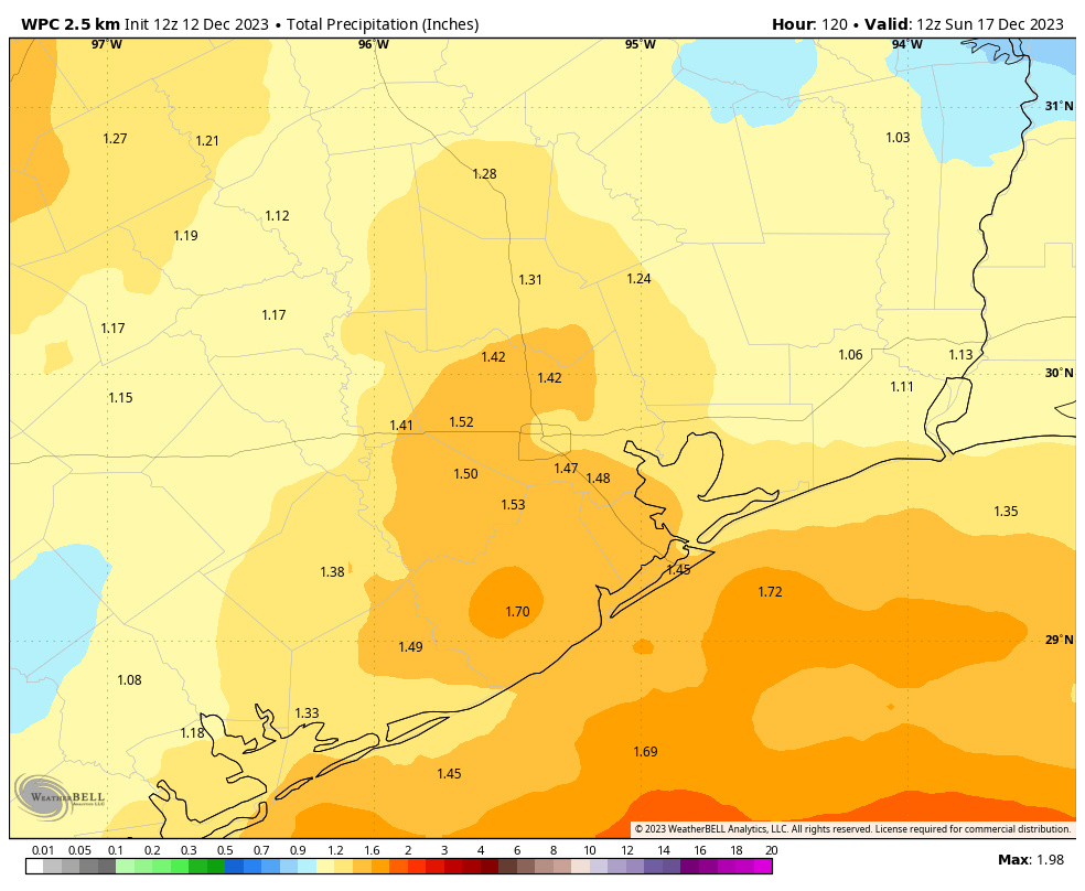
This should be a mostly cloudy day, with high temperatures in the low- to mid-60s. Rain chances won’t be zero during the daytime, but they should be fairly low before the afternoon hours. Then, especially from Friday evening through Saturday morning, we’ll see widespread showers ahead of, and along with the next front. I don’t think we’re looking at any appreciable flooding, as most areas should pick up 1 to 2 inches of rainfall. However, this rain definitely has the potential to put a damper on any holiday activities you have planned from the period of Friday afternoon through Saturday morning.
Saturday
Temperatures will fall to around 50 degrees on Saturday morning, and will struggle to climb out of the 50s during the afternoon hours as northerly winds blow into the area, bringing cooler and drier air. We may see a bit of sunshine on Saturday afternoon as skies start to clear, and any lingering showers move away. Lows on Saturday night will drop into the mid-40s.
Sunday
This will be a mostly sunny day with a high temperature of around 60 degrees. Winds out of the north, gusting to perhaps 15 to 20 mph, will keep things feeling on the chilly side. Sunday night looks rather chilly, with lows in Houston dropping to around 40 degrees.
Next week through the Christmas holiday
The early part of next week will remain on the chilly side, with highs generally in the low 60s and lows in the 40s. But we should see a warming trend toward next weekend, with highs perhaps reaching 70 degrees by Friday or so. And after that? As of now there is no appreciable signal for cooler air, so at this point I expect we’ll see a warmer than normal Christmas, with highs perhaps around 70 degrees. We shall see.
Blowing up a tornado
Last weekend saw a tragic outbreak of tornadoes in Tennessee that killed six people and injured more than 80. Some interesting video has emerged of one of these tornadoes striking a power station, and this appears to disrupt the the circulation of the tornado. This has led to some speculation on whether it’s possible the “blow up” a tornado. Over on The Eyewall, Matt dives into this phenomenon.


What’s it looking like in Conroe on Friday evening? I get married and the fiancé is hyperventilating over the chance of rain. I told her I’d check in with my best weather guy. I honestly don’t know how to navigate the website enough to actually check myself so I’m asking here. Lol
“Then, especially from Friday evening through Saturday morning, we’ll see widespread showers ahead of, and along with the next front.”
From above.
According to the Weather Channel, in Conroe, on Saturday morning, there is a 40 to 42% chance of showers in the morning and cloudy in the afternoon. I hope that helps.
Certainly no one plans an outdoor wedding without an indoor contingency.
No matter what happens, your wedding will be BEAUTIFUL 🌺
I love art, and sometimes there are mistakes: you think OMG & zap, there goes the energy, vortexing in an undesired direction.
THAT is when you have the powerful option of (01) of shrugging your shoulders (02) saying, what can I create out of this and (03) watch something beautiful and unexpected arise, far more miraculous than anything you had planned for 💓
Tell her it will be fine, your joy is not contingent on the weather.
And no matter what happens, your wedding will be BEAUTIFUL, bc it will be ⚘
Love to you both 🌹
TBH all I want is NO HARSH FREEZES! We don’t need a third one as it only kills plants and not those stupid mosquitoes. Also the fall colors are glorious this year!
My 40 ft Washingtonian barely survived the Feb 21 and Dec 22 sub 16F hard freezes. Agree a 3rd would be bad on top of the drought and on going dry fronts. Still 16” below normal rainfall (30 yr average) at Hobby! Judah Cohen seems to be the expert on polar vortex destabilization so check it out. Arctic hard freezes arrive when the vortex elongates. Sci Guy was all over this in 2021 to the extent that electric grid unpreparedness was a travesty. Destabilization is predictable weeks in advance.
I’d love a winter without another hard freeze. There are a number of trees and plants that won’t grow down here anymore. I lost several mature queen palms for example but many other species too.
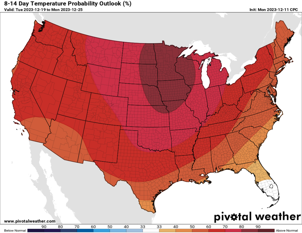
Your graph looks like it’s going to be 90 degrees in MN over Christmas but squinting at the 4 point font it had something to do with “normal”. Seems deceptive.
On the top of the chart is an “8-14 Day Temperature Probability Outlook (%)” So the number “90” probably means that there is an 80 to 90 percent chance that Minnesota has above normal temperatures which would be 30° Fahrenheit to 47° F. I hope this helps.
Correct. The chart clearly shows % expectation, not temperature expectation.
There’s a big difference between what should be growing here (native and ecoregion specific) and what people want to grow, usually not native. You always take a risk with non-natives.
On the subject of potential arctic outbreaks, northern Asia (Siberia) is experiencing a vast and intense deep freeze. Granted, this is within the realm of “normal” but I’m hoping that it doesn’t portend anything drastic for us later in the winter.
As long as you don’t cross Putin, you shouldn’t expect to be anywhere near Siberia, so, relax comrade.
The steady wind has been fairly punishing
What is your prediction for wind speeds associated with the front moving through on Friday?