In brief: In today’s post we take a look at what parts of the country will experience a White Christmas. It won’t be Houston of course, nor any place within 1,000 miles. We also discuss our brief cooldown tonight, warming weather for the weekend, and when it might get cold again after Christmas.
A White Christmas?
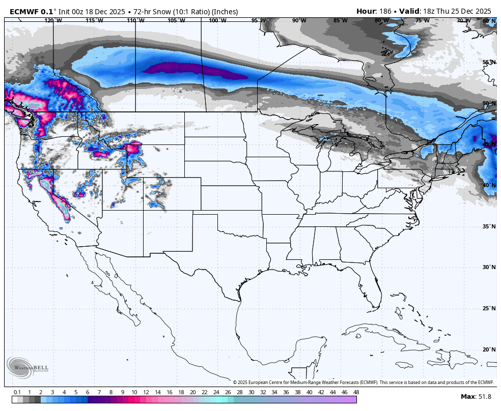
Will anyone in the Lower 48 have a White Christmas this year? Only a very few areas will be cold enough and wet enough due to a large ridge of high pressure establishing itself over the United States. Here’s a map showing 3-day snowfall totals preceding Christmas morning. Unless you live in the Pacific Northwest, Sierra Nevadas, Rockies, the upper Upper Midwest or New England area, you’re out of luck.
Thursday
Last night saw periods of dense fog, but this has begun to clear even before sunrise this morning, helped by light winds. In the fog’s wake we are going to see mostly sunny skies later today, with highs generally reaching the mid-70s. A front dropping down from the northwest may shave a couple of degrees off these highs for far northern areas, but for central and southern parts of the Houston region, the cooler air is unlikely to arrive until around sunset or after. Temperatures will drop quickly this evening, reaching the low 40s by Friday morning for all but the immediate coast. Winds will be gusty overnight from the north.
Friday
If you wonder what late December is supposed to feel like, Friday will be the day to step outside. We are going to see normal highs for this time of year, in the mid-60s, with sunny skies. Winds will be from the north, then the northeast, eventually swapping to come from the southeast overnight. This will moderate lows to fall only into the 50s for Houston.
Saturday
The first half of the weekend will bring gusty southerly winds as the onshore flow returns in force. Skies will be mostly sunny, with highs pushing into the mid- to upper-70s. Lows on Saturday night will only drop into the 60s, nearly 20 degrees warmer than normal for this time of year.
Sunday
Another day in the mid- to upper-70s (a few inland areas might briefly touch 80 degrees). Skies should be partly cloudy, and there is the barest chance of light showers during the daytime. Probably not for most people, though.
Next week
We will fall into a familiar pattern for pretty much all of next week: Highs in the mid- to upper-70s, lows in the low- to mid-60s, partly sunny skies, and so on. Because of the thickness of a ridge of high pressure sitting over the southern United States, our weather just isn’t going to change much. We’ll see plenty of humidity for late December, and the potential for foggy mornings depending on dewpoints and winds. Daily rain chances will likely be on the order of 10 percent. This pattern will hold into Christmas Day, and likely into Friday or Saturday of next week.
After this point the majority of our modeling is showing a change about 10 days from now, ahead of the new year. There is enough agreement in the models that I’m reasonably confident we’ll see a return of winter before the end of the year. This far out we can’t be certain, but it does seem likely.
