Good morning. The Geminid meteor shower—typically one of the best of the year—peaks tonight into Thursday morning. Unfortunately, we’re going to be mostly clouded in in the greater Houston area. The nearest chance for clear skies liest to the west of areas such as Sealy, or northwest of College Station tonight, and even that appears to be far from a sure thing. There is the possibility for some clearer skies on Thursday evening, although the meteor shower will be less prominent by then. Sorry, stargazers.
Wednesday
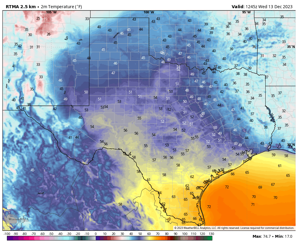
We’re seeing some light showers to the southwest of the region this morning, in the Port Lavaca and Victoria area. Some of these rains may work their way into the Houston metro area later this morning for areas to the west of Interstate 45. Any accumulations should be slight. Otherwise it will be, as mentioned above, a mostly cloudy day and night. Highs will reach the mid-60s, with overnight temperatures dropping to around 50 degrees in Houston. Winds will be about 10 mph, out of the east.
Thursday
We’ll probably see a little more sunshine on Thursday, and that should nudge highs into the mid- to upper-60s across the metro area. Winds will also be more prominent out of the east, gusting up to 20 mph, and increasing atmospheric moisture levels ahead of increasing rain chances on Friday. Lows on Thursday night will drop into the mid-50s.
Friday
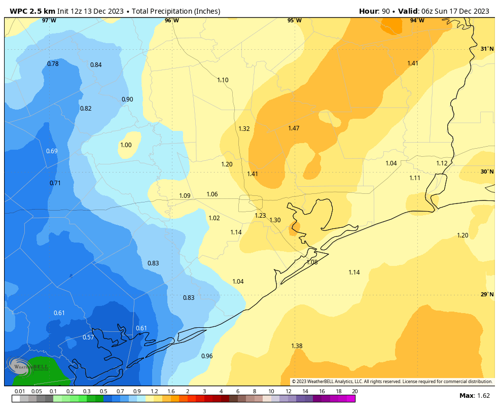
Friday will start out cloudy, and I think rain chances are going to hold off until at least noon. However, after that time a broad upper-level storm system will move in, and we’ll see showers and thunderstorms marching into the metro area from the west. This activity will likely peak from late afternoon through early Saturday morning, with showers and some heavier downpours. I don’t think we’re looking at anything too extreme, but most of the area should pick up 0.5 to 2 inches of rainfall. Highs on Friday will top out in the mid-60s.
Saturday
Lows on Saturday morning will drop into the 50s, and we could see some additional light showers lingering into the late morning hours. Mostly cloudy skies should limit highs in the upper 50s, and winds will be prominent out of the north at 15 mph with gusts up to 25 mph. So although the rains should be ending by Saturday afternoon, it’s still going to be breezy and cool. Lows on Saturday night will drop into the 40s with mostly cloudy skies.
Sunday
We should see clearing skies on Sunday, with highs of around 60 degrees. A persistent northerly breeze will remain, with gusts continuing at 15 to 20 mph. Lows on Sunday night will again drop into the 40s as winds finally start to slacken some.
Next week and Christmas outlook
The first half of next week should see continued chilly weather, with highs in the 60s and nights generally in the 40s. By Wednesday we should start to warm some, with highs approaching 70 degrees toward next weekend. I’d say the forecast for Christmas Eve the Christmas Day remains rather unsettled. We could see some kind of a front coming through the area next weekend (Christmas is on a Monday) and that may bring some precipitation and colder air for the holiday. Or not. There’s just not enough consistency in the forecast models, or overall pattern, to have any confidence. For now my guess would be highs in the 60s on Christmas Day with at least a decent chance of rain. But there’s a long way to go.


Eric, why is Hobby airport recording much warmer mornings compared to its surroundings these days? Compared to IAH for example it is 8 degrees warmer this morning. Is there something to explain this or is Houston just that huge?
Urban heat island effect is most pronounced in the winter, and especially overnight/early AM.
HOU is much closer in the city than IAH, hence the temp difference. Not uncommon to see deltas of 10F between downtown and outer suburbs this time of year.
Yep, I’ve observed that in real time on multiple occasions driving towards downtown on 45 after visiting friends up near The Woodlands. Especially at night during the winter, my vehicle’s external temperature display will steadily rise the closer I get to I-10, and usually by several degrees. It will then decrease as I head west out of the city.
Interesting. I always thought Hobby was less urbanized, but I just found out it’s about 11 to 12 miles closer to the concrete jungle city. Shows how pronounced urban islands can really be.
At this moment, at 8:17 am, the Bush airport zip code shows 51° Fahrenheit and the Hobby airport zip code 54° F.
Not much rain coming again looks like. Models did poor job not predicting the rain this morning off the gulf around matagorda and pushing inland. Don’t know what to believe now days. Everything is hit and miss, isolated, streaky, chaotic
Why the words “prediction” and “forecast” are used. Might be good to be reincarnated as a weather person – can be 80% wrong at work and still have a job 🙂
Probably wasn’t on radars because chemical trail planes seeded the moisture in the air throughout the day yesterday.
And before you call me a tinfoil hat head; here’s the address to the government site explaining cloud seeding: https://www.tdlr.texas.gov/weather/summary.htm
I would say that the narrow definition of El Niño based on SSTs only has been met. Strongly in fact. But SSTs remain hot everywhere. This is not classic El Niño. Weather response to these ocean temperatures is not modeled. Eric laid it out very nicely last week. I expect the models will need some real time tuning.
The rainfall accumulation forcast gets lower and lower each day. At this rate we will probably end up getting little to nothing as usual.
Exactly. Seriously, Eric, do you know what the deal is with this “el nino”? I mean, for example, California also has been drier than average this fall.
I agree completely.
Written in forecast:
Some of these rains may work their way into the Houston metro area later this morning for areas to the west of Interstate 45.
:end quote
Yep! We are midway-to-west of/between Magnolia and Tomball … light rain for the last hour or so.
Hopefully, I can still light the burn pile this afternoon 🙂