In brief: Our first real legitimate autumn cold front will arrive on Saturday, and it should usher in an utterly spectacular fall day on Sunday. This will be followed by a return to a stubborn offshore low pressure system and front to drive up cloud cover and rain chances for next week. We continue to babysit it for tropical development but do not expect it to organize at this time.
The last time Houston had an official low in the 60s, the Astros were 25-33, behind both the Rangers and Mariners in the AL West standings. Despite a rough few days in Cincinnati, the Astros are 10 games above .500 and sitting 4 and a half games up on the Mariners. Our friends in Arlington are 8 games out of the last wild card spot. It’s been awhile. And this weekend, we should get to experience both a much better positioned baseball team than May 31st, as well as the coolest weather since then.
Today
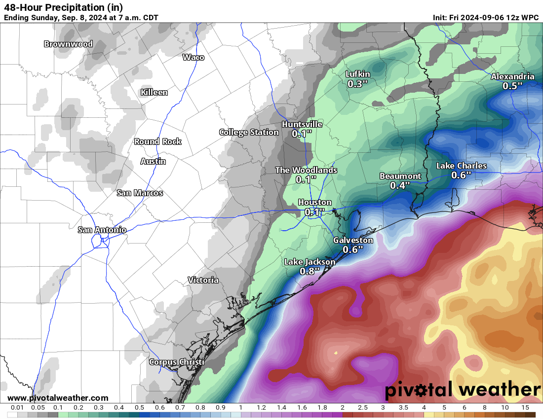
It’s been a wet stretch. Galveston has had nearly 10 inches of rain since late August. Bolivar has seen 15 inches. We’re going to see the rain begin to slow down now, and we will drop the Stage 1 flood alert for the coast today. We may still see some showers today, especially at the coast again but it should be manageable in most cases. Other than that, expect clouds and sun with highs reaching into the middle or upper-80s.
Saturday
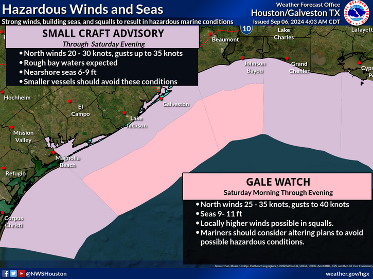
As the offshore low pressure system that’s flung rain our way begins to migrate eastward tomorrow, the much advertised cold front we’re expecting is en route. This drier push of air will help shut down the moisture feed inland, reducing shower chances to merely a passing chance at the coast tomorrow. There will be a bump in wind tomorrow at the coast, however, and there are small craft advisories and gale watches posted.
The cold front itself will probably push into Houston sometime around early afternoon. I doubt you’ll notice much as it passes. Humidity will gradually drop off later in the afternoon and evening, and that’s when you should really notice a change. The Dynamo game will be great. Temps will peak in the mid-80s after morning lows in the 70s. We may get back into the low 70s and have a midnight minimum temperature on Saturday night.
Sunday
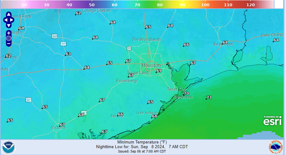
Sunday morning should dawn sunny and delightfully pleasant. Lows in the 60s with low humidity, dewpoints in the 50s, and a slight breeze. Even Sunday afternoon will be nice, with highs in the low-80s. If you’re in Indy for the Texans opener, it’ll be in the 40s for morning lows, so any early tailgating may need a jacket up there! Really, just a delightful day. Maybe we can even get the roof open at Minute Maid Sunday night?
Coastal locations will have the trickiest forecast on Sunday. The front should clear the coast, and there should be that push of dry air all the way past Galveston and down to Matagorda Bay. However, there’s always an off-chance that something is being missed in the model guidance and we end up cloudier or a little more humid than expected down that way. Just something to note.
Next week
If you’ve been reading Eric’s posts here this week or my posts at The Eyewall, you know we are still monitoring the potential for tropical development in the Gulf next week. We don’t think anything will formally organize from this, but the Gulf, September, etc. You just have to babysit it.
Regardless of that, it is likely that some type of low pressure and/or stalled front sits off the Texas coast next week, similar to what we’ve been dealing with this week. In that scenario, we will likely see rain chances return as early as Monday and particularly on Tuesday, Wednesday, or Thursday. We could again see locally heavy rain, especially at the coast. And this is without tropical development. If we were to see tropical development, that may actually help keep more rain offshore, as the system would probably track just east of our area. So while our base case forecast will call for no tropical development, it does at least merit mentioning and babysitting on our end. We will keep you posted through the weekend and have more tomorrow or Sunday if necessary. That being said, the rain totals over the next week continue to look rather impressive, so we’ll have to keep an eye on how that unfolds going forward, particularly for saturated coastal locations.
Tropics
Beyond the potential development from the Gulf low next week, there is very little for us to discuss in the tropics as it relates to Houston or anywhere for that matter. The next wave to emerge off Africa heading into next week seems to have a decent chance of developing but also seems as if it will turn northwest rather quickly and stay out at sea. Given the expectations for this season, this is as good as you could ask for on September 6th. Fingers crossed it continues.

Does an ongoing low in the Gulf at this time (September) have any impact towards lowering water temp and future storm chances? Trying to think positive here in Surfside
Whew! Breathing easier 😀
Most years the first cold front signals the end of Houston’s hurricane season. That probably isn’t the case this year. Any thoughts?
While the first cool front is a good sign, we aren’t out of the danger zone until at least the 2nd or 3rd typically.
Cold fronts don’t really have an impact on hurricane season. It just seems that way because the first cold front usually comes later, towards the end of hurricane season. We just happen to be getting an early cold front this year.
On Tropical Tidbits, this morning, ICON has something (995 barometric pressure) hitting us straight on, on Sept 11th..I know these model runs constantly change, with that said, Weds isn’t that ridiculously far off…GFS also has something in the (998 barometric pressure range) hitting the upper part of the Texas middle coast similar time frame..Thoughts?
That’s the wannabe Storm that can’t Form – a gasping system that can’t make it bc of the lovely front coming down (+ other factors in our favor)
Time for Halloween decorations! 🎃
I hope so…Yesterday a local weather news guy, said the cool front will be sliding away quickly, around Monday afternoon, and we are predicted to begin another rainy few days all over again,(next week), should nothing stronger develop …He mentioned that we in TX/LA still have to keep a close watch for something to spin up..The timing of the cold front may or may not be a non issue for the wannabe storm, but I hope the other factors play in our favor..
Hi @Lisa … thanks for mentioning Tropical Tidbits – I’ve never seen that website 👍
After tinkering with it for a few minutes, I clicked the ‘About’ link. Turns out, the author built it in his dorm room back in 2012, and been enhancing it to this day (has a Ph.D in Meteorology from Florida State).
Great site, with lots of cool features! He also contributes video discussions at Wunderground since 2005, which I did not know – I use Wunderground all thru the day to keep track of radar and PWS’s around us.
It’s Levi, used to chat with him on the blog back in the day
I really like Levi! Once an invest becomes a named storm, (time and equipment permitting), Levi gives us a daily video update about said storm..He explains the science behind what’s going on in a given storm, breaks it down in layman’s language…
I get that Harvey and Beryl have everyone here on edge. But man, you gotta stop stressing so much over individual operational runs of these models. NHC has been consistent with keeping this at 20-30% or less, SCW has been consistently saying they don’t see anything to worry about. Likely scenario is we get the cold front and then when it backs off, we are back to a soggy week. Granted, I’m sure those along the coast are less looking forward to a soggy week.
Lol, I’m sick of the soggy conditions in my neck of the woods…Miss grandma Lisa(me), hates traveling an hour and a half across Houston in the rain…I’m due at my granddaughter’s 8th birthday celebration next Sat the 14th..So I’m hoping and praying it’s all sunny and dry by then…
I think that is important to consider. I remember Hurricane Barrel and they said, oh it is going through North Mexico and then it was going to be around the border, and then it was going to be around Victoria, and then they were like, “Look outside, it’s right here!”
Consider last week people here were already proclaiming a hurricane was gonna hit Houston based on early long range models. Now its all about the first cool front and fall weather excitement
One coolish less humid day..Apparently the cool front backs off Monday, and we’re back to humid onshore flow.. When the invest approaches our part of the gulf, I hope something keeps it from giving us too much of a headache…
*it’s
@Lisa Right now my Ventusky app shows the ICON model track of an invest heading south about to the latitude of Tampico, then reversing and coming right back to the upper Texas coast. ICON correctly nailed greater Houston as the final target of Beryl shortly after it entered the Caribbean. ICON was right, that far out, which is pretty unusual. So yeah, it makes you wonder if it’s on the money again.
Hi @voter_worker … you beat me to the punch per Ventusky. Yes, Ventusky accurately predicted Beryl to come right up thru the Houston area, when other sites were predicting landfall much further south Texas.
I took a screenshot earlier today, showing the path Ventusky is suggesting. It’s showing anticipated landfall for 90L between Tue Sep 10 and Wed Sep 11. I’ve texted the screenshot and info to our family members who live in Surfside and in Lake Jackson.
This oddity is probably what @Lisa offered earlier today when they posted the Tropical Tidbits website anomaly for Sep 11.
And guess what else has just been upgraded? The NHC has upgraded “Disturbance 3” (SW Gulf of Mexico) to 20 percent at 48 hours and 40 percent for seven days. (vs 10 and 20 percent).
Ventusky didn’t predict anything, it simply shows model runs (which you can select and see the different results from the other models). The ICON isn’t regarded as a very reliable model and is generally not used when predicting storms. It just happened to get Beryl right sooner than the others this time.
Can next week’s tropical system stall offshore and set up an atmospheric river over Houston ? Is this incoming front increasing or decreasing this possibility?
Ugh. More rain. Ugh.
Same. 🙁
I’ll take another week of soggy over another week of sultry easily.
Only adjustment is to keep the heavy rains over the Gulf. If the water is coming from there, let it fall back there.
Yesterday, I mentioned the rains would dissipate as they approach our area (Magnolia), for the last 10-14 days.
Well, early this morning, was awakened to the sound of rain sliding down the roof and ‘clinking’ as it fell into the roof gutters.
Got up near 7am to go for the morning walk. Checked the driveway security camera and it showed a wet driveway from about 3am until 6am. So, no sprinkler required today 👍
“cold front” lol nothing cold about that or even remotely fresh
I like to say ‘cool fronts’ but we’re talking upper 60s and dry air? I’ll take that chance to open up the windows at night and get some fresh air into the house.
Everybody excited about a cool front dropping temps into the 60s and dry comfy air. Thinking about Halloween decorations and pumpkin spice.
Going to be in rude awakening next week possibly from gulf as it’s prime time peak season. Violent delights have violent endings
LOL are you okay there, bro?
Astros actually have a 3:10 start tomorrow, so will surely use upper 80’s temp as excuse to keep it closed – same for Sunday. Don’t even get me started on this issue!
Some Debbie Downers on here this morning. I’ll take the drinking coffee on my patio Sunday morning in the upper 60’s with dry air! Can’t rain on my parade. HAHA! Happy weekend, friends!
I don’t mean to be a Debbie downer, just relaying the stuff I keep hearing..Because I like to ask questions…Local news guy thinks that the cool front will not reach far enough south to affect the disturbance down by the Yucatan. The cool front is predicted to push the mess that is currently near our coast, southward, where it could possibly hook up and have fun with the disturbed blob that is at or near the Yucatán… All of this moisture to be pulled back to the north once the cool front passes.That’s what’s been seen on our models…Resulting in pesky gooey oopy rainy weather drenching us for much of next week…Nobody’s been able to narrow down whether or not we will get high winds with the heavy downpours..
We were sitting at less than 1/10 of an inch over the whole thing this past week. Finally had a band set up over us for a few hours yesterday and got over an inch of rain slowly. Absolutely perfect for the trees and grass!
To be accurate for the Houston climate, these fronts should be called “less-hot front.”
Go ‘Stros‼️
Come on down Mr Cold Front!!!