In brief: Today’s update digs a little deeper into our lack of rainfall during the second half of summer, and whether we’re going to see relief any time soon. The answer is maybe, and that especially coastal areas have a healthy chance of rain this weekend. Then, by early next week, passage of a decent fall cool front looks increasingly likely.
Drying soils in late summer
Houston started out this summer with plenty of rain. You may remember Hurricane Beryl in July? But by the end of that month conditions turned notably drier. And but for a wetter spell in late August, the last two months have been quite dry. Our soils feel the lack of rain especially keenly during August and September, as these are often the hottest months of the year, which dries things out much more quickly. Looking at the last 60 days, we can see that much of the Houston area received less than 50 percent of normal rainfall, and some western areas less than 25 percent.
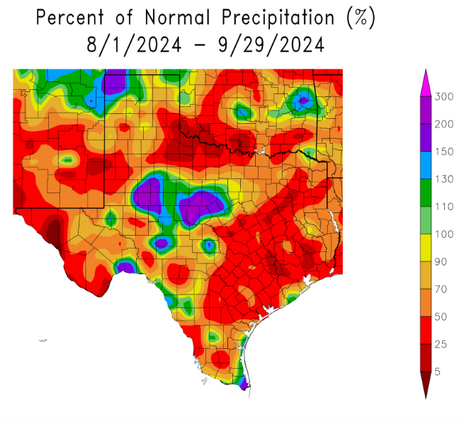
So far this has not resulted in drought-like conditions—something for which we can thank Beryl. However, in the latest update from the US Drought Monitor, the northern two-thirds of the Houston region are classified as being “abnormally dry.” This is just a step short of falling into a drought. I write all of that to say we could use some rainfall this month. Our next chance comes this weekend, but unfortunately it looks like the highest odds for rainfall will be closer to the coast, areas which generally are doing OK with rainfall. Would that I had better news.
Tuesday, Wednesday, and Thursday
Warm, but calm, weather will continue through much of this week. We can expect sunny days, high but not excessively so humidity levels, and sunny skies. Daytime temperatures will be in the low 90s, with overnight temperatures in the low 70s. Winds will be light all three days, from the north and east, typically not getting much above 5 mph. You probably won’t believe me, but we’re coming to the end of the time of year when we see long strings of 90-degree days, so if you like pool or beach time, this is a good week, and weekend for that.
Friday, Saturday, and Sunday
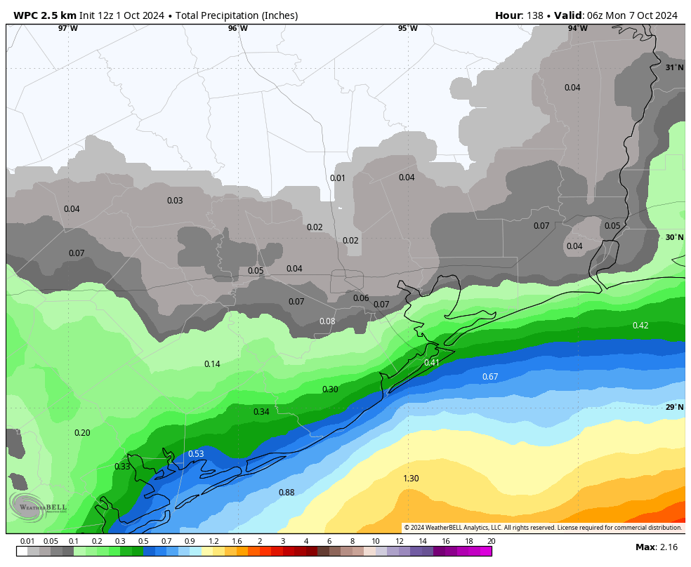
As noted above, our region will see some better rain chances starting Friday and lasting through the weekend. In the absence of high pressure, and with increasing levels of moisture in the atmosphere, we should see some clouds start to build on Friday, with partly to mostly cloudy conditions on Saturday, before more sunshine on Sunday. The models have gotten a little more bullish with rain chances for the weekend, especially on Saturday. However, you should set your expectations accordingly, especially if you live inland of Interstate 10.
My sense is that there is still a lot of uncertainty in the rainfall forecast so expect some change. However, if you live in a coastal county your chances of rain are probably higher than 50 percent on Saturday, and a bit lesser on Friday and Sunday. Further inland, along Interstate 10, rain chances are probably about 40 percent on Saturday, and the further you go from the coast, the lower things get.
High temperatures this weekend will be on the order of 90 degrees during the daytime, with a decent amount of humidity, and lows generally in the mid-70s.
Next week
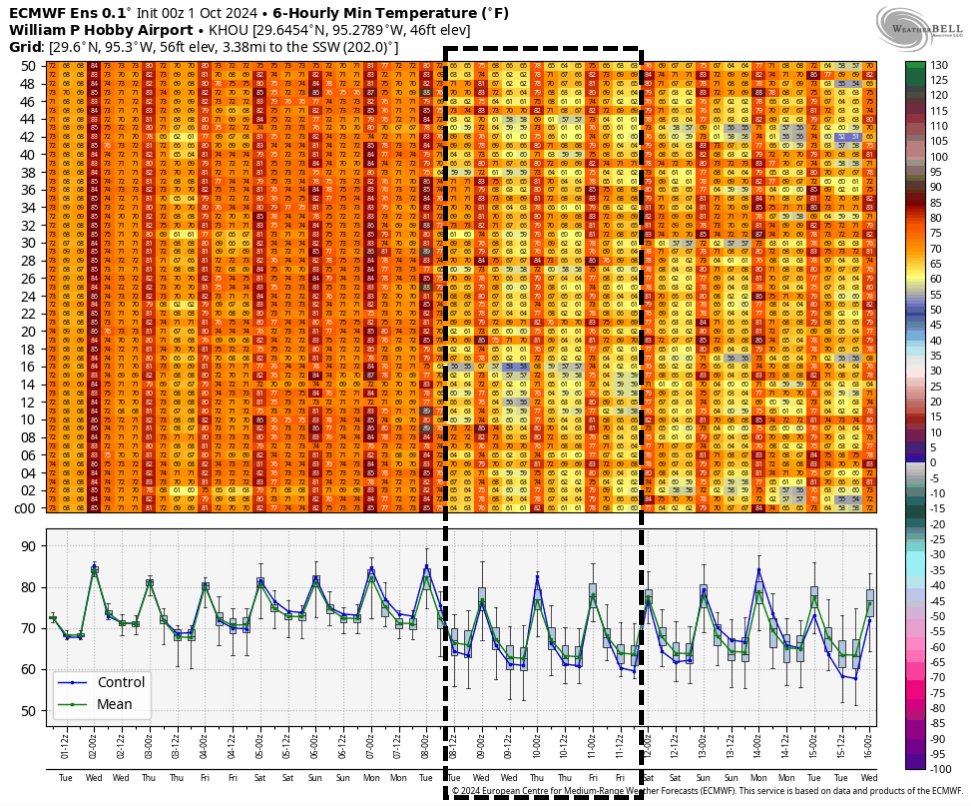
Confidence is increasing in the arrival of a cool front early next week, likely some time on Monday or Monday night. It is not guaranteed, but there is now support in a lot of our modeling guidance for a decent push of drier and cooler air. I would expect mostly sunny weather next week, with highs in the 80s and lows in the lower 60s, but this is going to depend on the extent of the frontal push. A majority of the colder air with this system is going to get shoved east, rather than south, so we’ll have to wait and see how much relief we get. Despite those caveats, however, I’m optimistic. A little fall weather would hit the spot.
Tropics
There’s a lot going on out there, and if you want all the details we’ve got them on The Eyewall. But if you’re simply wondering, “What does this mean for Texas?” the answer is, not much. It’s been a week since we called a halt to the Texas hurricane season, and I still feel pretty good about that prediction.

What about the very large area in the GOM predicted at 40% for development? Is this anything we should be concerned with?
How many times does the man have to say No?
Damn.
Some people are slow learners. And, others are very slow.
Click on “The Eyewall” for a detailed discussion of what’s cooking as far as tropical weather..
Climatologically, thru history, tropical weather likes to go east of us in Texas, the deeper into the fall we get..But never say never…I mean we DID have a hurricane strike us in the first week of July, which was unprecedented…I don’t trust anything any more..I would not be surprised to see tropical mischief in December, since unprecedented happenings have become our new normal..
This is par for the course with a La Nina Fall/winter. The polar jet stream tends to stay north of Texas which steers the cooler air and rain making lows away from Texas leaving us warmer and drier than normal. We will still have brief wet and cold spells but the trend is going to favor dry and warm weather for the foreseeable future. I pretty much guarantee we will be in a solid drought if not later this fall, then probably by next spring.
That is a great user name.
Looks like its going to be one of those Hot/Warm dry Falls this year. TWC has 90 degree days thru mid October for us. SMH.
Gross.
Eric, I enjoyed your interview on EarthSky yesterday. That side of your work is always very interesting.
Very kind, thank you!
Eric, Excellent Artemis analysis over on Ars Technica today. Joe
Thank you! I imagine it won’t be all that popular with some people in Houston, unfortunately.
Maybe scrap the entire manned space program altogether. It seems to be more like ‘Hunting the Snark”, an impossible quest. Use whatever resources that are available to take care of the myriad of problems down here on earth that are manageable. So, what if China and Russia (if they can ever get their combined acts together) get to the moon, are they then going to rain missiles down on the rest of us? I doubt it, the technology to have weapons enter earths atmosphere is a million years away, most of us will be long gone to worry about that. It all sounds like so much of vanity project to boost someone’s ego at the expense of the rest of us. I mean. good grief, we don’t even have traffic lights down here that work much of the time if the wind blows.
Thus is coming from someone that continuously asks if every storm that emerges will somehow hit Houston, even when the forecast says its heading nowhere near Texas Ken still thinks worst case scenario every time
You clearly are thinking – if that is at all possible – of someone else.
I think you mean Matt J – that poor guy is so worried all the time.
What a NASA manned space project that is years behind schedule and billions over budget? Like we haven’t seen this before. Stick to robot explorers and telescopes.
Highs in the 90s the first week of October? Sound more like Yuk-tober to me.
Bring on the cool. I’ve got stuff to do in the yard.
Pulling my permits for my patio soon, I can’t wait for cooler weather to get this done.
I have noticed more and more over the years that cool/cold fronts are sliding over more towards the east.