In brief: A major winter storm continues to look likely for the Houston area Monday night and Tuesday, with the potential for heavy snow and sleet in parts of the region. Minor ice may occur near the coast, along with windy conditions. Travel will become difficult to impossible Tuesday morning and remain that way through at least Wednesday morning across most of the area. A significant, damaging freeze is likely Wednesday morning as well. We do warm up Thursday.
Current cold
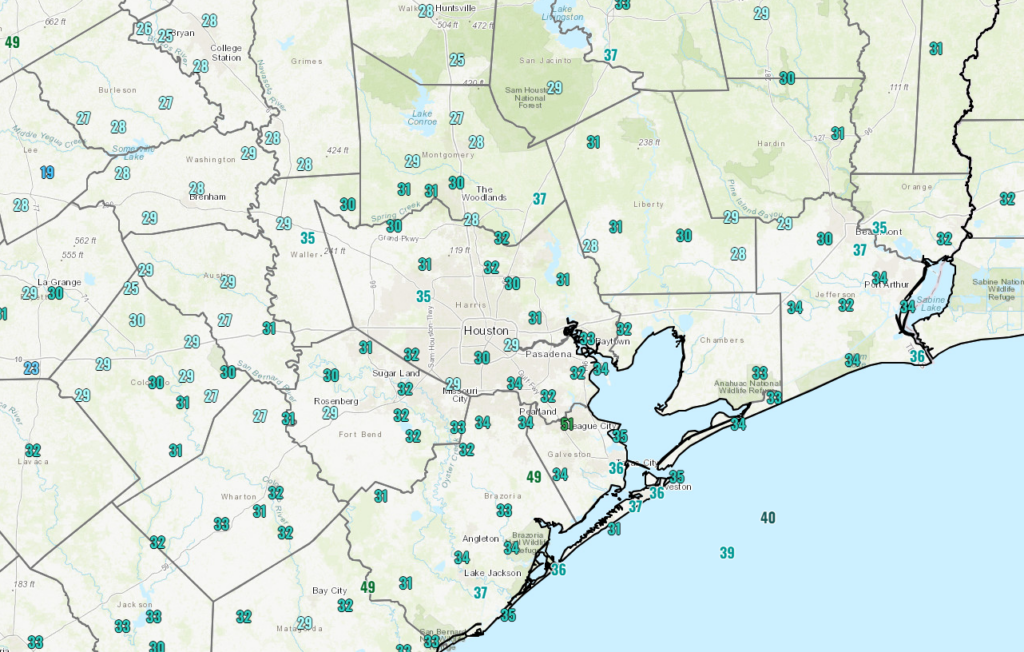
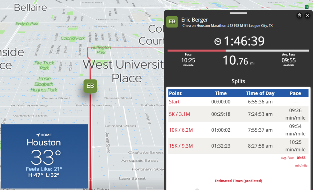
If you’ve stepped outside, or like Eric, started running the Chevron Houston Marathon, you know it’s, um, cold.
Speaking of which, let’s check on Eric as of 8:40 am! Good luck to Eric the rest of the way!
Temperatures will recover some today, getting up into the low or mid-40s. Another cold night is expected tonight, with lows in the 20s across most of the area away from the coast. Expect a hard freeze for many outlying areas and some areas in the city too.
Remember the basic preparations you should be taking.
- PLANTS. Protect tropical vegetation. Please note, with temperatures dropping this low, some vegetation will probably die regardless.
- PIPES. Protect any exposed outdoor pipes. Pipes in attics and along exterior walls of structures could freeze at these levels.
- SPRINKLERS. Sprinkler systems should be shut off and properly drained.
- ANIMALS. Prepare proper shelter and warmth for animals and livestock and make sure water sources are not frozen.
And also remember to check on people that may not have adequate insulation or access to heating.
Monday
Most of tomorrow should be fine. We will see increasing clouds that may hold temperatures back a bit. Highs should be in the upper-30s. Precipitation begins sometime either Monday afternoon or evening. With temperatures comfortably above freezing, whatever falls initially may be a light rain. Resist the urge to call bust.
Sidebar: The air mass over us will be quite dry. This is important. As the rain begins falling on Monday afternoon and evening, it may fall as virga (rain that does not reach the ground). But as it evaporates on the way down, it will cool the entirety of the atmosphere from a few thousand feet up to the ground. This is essentially priming us for snow and sleet. So initially, it may fall as rain, but that will change Monday night.
The best advice we initially can offer: Be where you need to be by early Monday evening and prepare to be stuck there through at least Wednesday morning.
Monday night and Tuesday morning winter storm
As the precip increases in coverage and intensity and temperatures drop, we will see a changeover from rain to a mix of sleet and snow. I have to be honest: Much of the model data seems to be favoring a gradual change from sleet to mostly snow, especially along and north of I-10. South of there, it should still be a mix of sleet and snow, with potentially a little freezing rain near the coast or Matagorda Bay area.
A couple notes about how things will unfold.
- This storm has been strongly signaling what we call mesoscale banding or the potential for a deformation zone. In plain language? There will be widespread snow and sleet, but embedded within that will be a couple corridors of heavy snow. Those bands can see quick, heavy accumulation and snow rates of 1 to 2 inches per hour, along with the potential for thundersnow.
- That banding will also lead to a disparity in snow totals. You could, in theory, have an area that sees 2 to 3 inches and literally down the road an area that gets 6 or 7 inches.
- Sleet is the biggest risk to all this. If we end up with significant sleet and less snow, accumulations will be much lower — but travel will be just as bad. Models are trending toward more snow over sleet for much of the region, but admittedly, this is not an area where models handle things super wonderfully.
- Wind will howl on Tuesday morning, especially on Galveston Island, where gusts could exceed 40 to 45 mph. Inland gusts will be to 20 to 30 mph. Coupled with areas of heavy snow, this will create extremely poor visibility and potentially some blowing and drifting of snow. Yes, that’s an actual sentence I just typed for Southeast Texas.
When all is said and done, how much snow will you get in your backyard? The official NWS forecast is shown below.
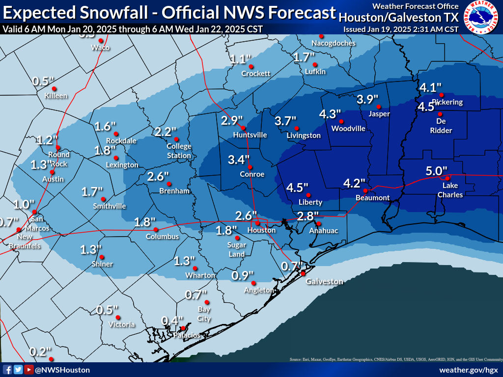
I will say that the risk is probably asymmetrically skewed to the higher side here. In other words, there is a chance of more snow than shown, but again it will depend on sleet and exactly where those “mesoscale bands” setup. Max totals could be, could be as high as 6 to 8 inches. But those will likely be the exception, not the rule.
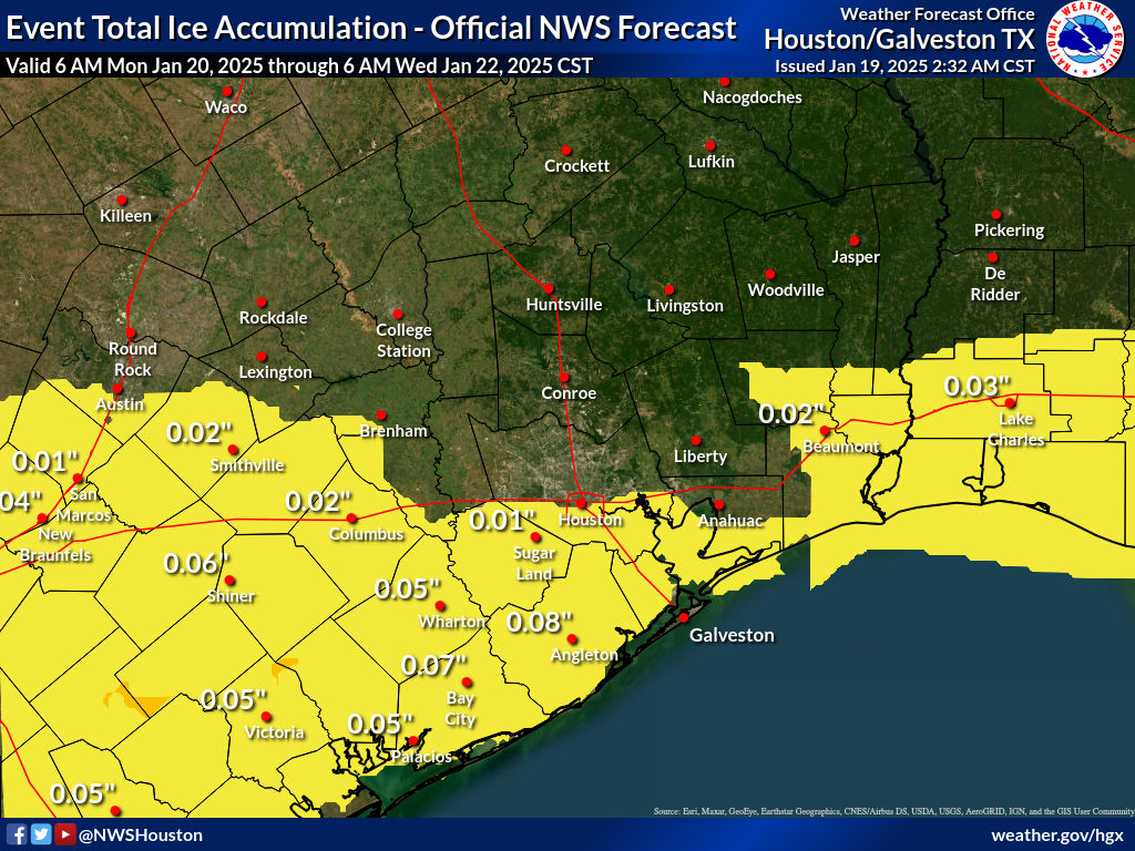
How about ice? Well, the official NWS forecast is one that isn’t overly bullish on ice, which is good news. Ice is where you can start to have more meaningful issues with infrastructure issues (trees, power lines, etc.). Ice of this amount would make conditions a little extra slippery but be unlikely to cause damage.
The highest ice totals are likely to be south of I-10 and in the Victoria Crossroads back toward south of San Antonio.
Travel concerns
There’s no real good way to get around this: We are inherently unprepared for a major snowstorm because, well, it rarely ever happens. Thus, you can expect that travel will be difficult to perhaps impossible on Tuesday, probably Wednesday morning, and maybe even Wednesday afternoon. We really cannot underscore this enough: Barring a dramatic forecast change, tou will probably not be able to get very far in a vehicle Tuesday or Wednesday morning. Your flight will probably be cancelled. Prepare to be stuck where you are after Monday evening.
Wednesday morning hard freeze
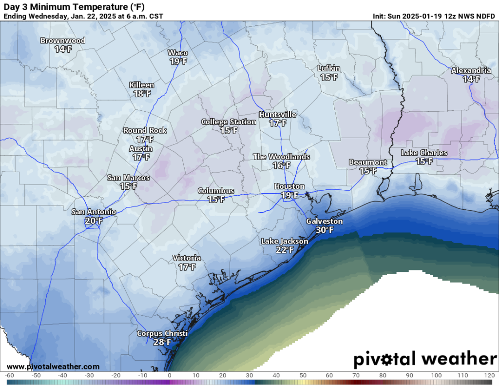
With ideal conditions for cold weather, including fresh snow on the ground, you can expect Wednesday morning to be very, very cold. While it won’t be super cold across the rest of Texas, locally here in Southeast Texas, we may rival one of our coldest mornings of the last few years.
Expect lows in the teens virtually everywhere away from the coast. Areas that see minimal snow accumulation will also likely be milder. This will be a hard, damaging freeze and maximum cold weather precautions need to be taken.
Wednesday afternoon should see sunshine but with snow and a bitter cold start, we will likely only get into the mid-30s or so. Another hard freeze is possible Wednesday night, albeit much less cold than Wednesday morning. And we should bounce back into the 40s on Thursday. Alas, the snow will melt.
Anyway, we’ll update you on any changes later this afternoon. But hopefully this post answers most of your questions in the meantime. Stay warm!

Very good presentation.
Go, Eric, go!
Yes! I love the fact that technology allowed Matt to post an Eric tracker. I need to remember this the next time technology frustrates me.
And thanks, Matt, for the cold morning post that was thorough, honest, and written in a human-to-human way. Just what I admire from you and Eric.
TFW a colleague in Minnesota (nicely) points out I’m about to get more snow than they have.
😂
Thanks so much for keeping us updated. Never lived in a cold climate so is 6″ shoveling amounts or just deep in the yard? I don’t plan on going anywhere from tomorrow afternoon until at least Wednesday afternoon and am good with that. Houston and ice never play nice. Pipes and plants wrapped but are there any extra precautions to take for snow around your house?
Thanks again, Matt.
Hope you thaw out quick, Eric
6″ is shoveling amounts on the drive and walkways. Just let it sit in the grass and take some nice pictures. Quick note on shoveling, a gallon of water is about 8 lbs. If you set a gallon jug of water on the end of a shovel, think of how heavy it might be for you to move. Now imagine your whole driveway covered in gallon jugs. If you’re in shape to move all that, go for it. If not, just move enough to get in and out of the driveway or just don’t do it.
Regarding house precautions, if you’ve got a cat, you can scatter kitty litter (the non-sludge kind) on your sidewalk to give yourself more traction as long as you don’t get the kind that turns to sludge, and you can sweep it away safely when everything melts. You can also throw down sand for the same impact.
If you have a city water standpipe that comes up on the outside of the house then goes in, obviously wrap it in some kind of insulation. The additional step is that if you have a tall enough box (thanks Amazon!) cut a notch in one end so you can push the box up to the wall, creating a cover for the whole stand pipe, then take a plastic contractor bag, cut a slit in it to accommodate where the pipe is and pull it down over the box, taping it in place. It’ll help keep snow and ice off the piping and keep the cardboard from soaking completely immediately while protecting it from the wind carrying away what little warmth the water will have.
If you’ve got window-shaker AC units but can’t get them out for whatever reason, you can take another contractor bag just sleeve it over the outside of the unit, then get some cheap bungees from Harbor Freight and wrap them around the bag as close to the house as possible, then take the excess bag and bundle it up, taking a second bungee and wrapping it around the bundle so that the excess doesn’t start flapping in the wind and taking flight. It’ll help keep the snow from getting inside the unit and freezing.
If you’ve got older windows with cracked grout, seals, or gaps around them, it’s too cold to caulk now. You can tear and jam soffit insulation or left over pipe insulation into the gaps to prevent air intrusion though. You could go one step further get one of those plastic window cover kits that has the shrink wrap in it but if you can’t, you can tape plastic sheeting into the window frame but depending on how much draft there is it might not hold.
Same thing around drafty doors or damaged weather stripping. Get something into that gap to prevent the draft like jamming foam or whatever into the gaps. You can also put old towels
If you have a carport or something like it, try to push some of the snow off the roof. Probably won’t be an issue with the amount forecast though.
If you intend to drive, give MUCH more space than normal and stay off of the overpasses. Yes it’ll take longer, but the overpass has exposure above and below to freezing air and is more likely to freeze. Ground based roads have less of this problem.
That kitty litter or sand you spread on your walkways? Throw them in your trunk, ESPECIALLY if you drive a rear wheel drive vehicle and EXPLICITLY if you have a truck. An empty truck bed in RWD is just asking for trouble because there’s nothing to hold down the rear wheels and the tail will swing all over. The engine usually is enough to hold the fronts down. If you hit deep enough snow to get stuck, the litter or sand can be used in a pinch to get enough traction under the wheels to get out.
Final word on driving, IT ISN’T A RACE. Think of it like driving while pulling a parade float. You wouldn’t be doing a grand prix with a float full of people on the back. Keep the speeds down and allot additional time to get places. Gentle, controlled acceleration, braking, and turns are the name of the game.
Just some winter wisdom from a former Yankee. (I married a Texan! It counts!)
Thanks so much! I know we have a box somewhere for the extra protection of the water line. Wasn’t sure how to keep snow off of it but that will work. Plenty of towels to lay at bottom of outside doors to help.
I won’t go anywhere when the roads have ice. Seen too much of the havoc that can be.
Hopefully power stays on so heater will keep up.
Really appreciate the ideas!
🌠 those are great ideas!
Idk but I’m pretty excited at the possibility of witnessing a rare event like thundersnow.
I experienced it when I was in college in Nebraska in the fall of 97. Last weekend in October snowstorm that took out a lot of trees because it was heavy, wet snow and the thundersnow increased the snowfall rates. It was crazy.
Yikes. Maybe not then. I’d rather keep my power.
Well, all very disappointing. I was absolutely sure the message this morning would be: “It’s all been a false alarm, weather back to the normal heat for this time of the year.”
On the subject of Eric running in the marathon; so, 4 1/2 hours on the current pace?
Ty Matt – I’ll be sno glad when this is over ⛄
The National Weather Service defines a blizzard as: a storm with lots of snow or blowing snow with winds in excess of 35mph with visibility less than 1/4 mile for a minimum of 3 hours.
Could they issue a Blizzard Warning for parts of our area?
That would be wild…
Matt, you and Eric do a great job of keeping us up to speed on the weather. Thanks for all your efforts and stay warm and dry.
Good post Matt. Appreciate seeing Eric’s progress too.
Slippery icy conditions are slippery icy conditions for most metro area drivers. Some of us learned to drive on ice, with or without snow covering it. However once 1 vehicle goes into a skid/spins out on HOU roads all havoc breaks out.
Drivers, if you want to take a spin, find your closest empty parking lot and do your doughnuts there, away from any fixed objects, please.🤣😵💫
Thinking of our first responders and their safety for critical emergency incidents. Don’t become an incident.
You should be able to track Eric here.
Thanks Dwight for the link. GO ERIC GO!!
As long as I have power it can get as cold as it wants.
Thanks as always for the great, no-nonsense information. I unfortunately have a flight scheduled to fly out of IAH around 10am Wednesday. The airline didn’t have much guidance so I was wondering if y’all may have some experience (with the caveat that there’s no way to know what will actually happen, ofc). I’m torn between keeping my current flight and expecting it be delayed, or switching to a flight out later on Wednesday and hoping it doesn’t get delayed or cancelled to accommodate earlier flights. Any idea if there a standard MO for cancelling vs delaying for weather events like this?
They will cancel everything rather than allowing delays to cascade is my guess. I doubt they even have de icing to get off the ground, so that means nearly everything Wednesday will stay grounded.
Add me to the chorus of thanks to Matt and Eric for the updates.
And, thanks to Dwight for the link to Eric’s marathon progress. It is fascinating, admirable, and amazing that people willingly run 26.2 miles.
Like others have said, I’m okay if the models get it wrong and this whole thing fizzles out or shifts to the east. As a native Houstonian, we aren’t built for the cold or snow so we can skip it in my opinion.
Matt, what a fantastic and thorough update! Perhaps you could come back to the space city weather side more often? Thank you!
Yeah, we love you, Matt!
💗
Still trying to decide if I should turn off the water to the house to protect pipes in attic? Thoughts? We live close to 45S & BW8.
I want to turn my water off but my shut off is buried under dirt and grass… guess they no longer read meters in person ever. Figure safer than dripping if electricity goes out
Um, wow! Possible drifting snow, thundersnow & 1-2″ per rates in SE TX! 🫣 Welcome to 2025!
Looks like Eric is almost finished! Good luck to him the rest of the way and thanks for the constant updates.
So are y’all wrapping pipes and dripping, or shutting water off completely?
Going to turn off the water at city meter and run them dry here in Galleria area Southwest Houston…I’m in an craftsman house. I read somewhere the City was requesting everyone to NOT drip their faucets …don’t know why. Best of luck!
thats cause everyone dripping at once could lead to low water pressure, which will let gross stuff back up into the water supply and put us under a boil water notice
On the subject of the Marathon; looking at Eric’s pace for the last few miles, I can only assume he must have been really hurting. Bravo for finishing, Eric. 🙂
I have pipes in the external walls. Is it better to cover the spigots or drip the pipes?
if you can shut off the water and let the pipes drain, that is best
Congratulations Eric!! Way to go and thank you and your entire team for the weather updates as always. Cheers
Thanks for today’s and every day’s weather info—always reliable and anxiety-relieving. Hope Eric has done well in the Marathon.
It will likely accumulate if it is steady, dry snow. The ground has been cooled down a lot by the cold weather we have seen this month so far, so I will say it probably will accumulate efficiently especially if the snow comes down heavy at times.
Eric is one dedicated guy!