In brief: After a quiet weekend, rain chances pick back up Monday and Tuesday before potentially heavier and more widespread rain on Wednesday and Thursday. Tropical development in the Bay of Campeche will not directly impact Houston, but indirect impacts with rough seas, gusty coastal winds, and some tidal flooding will be possible.
Right out of the gate, we want to make sure people understand that next week’s weather is being driven by two entities: The first is the potential tropical system in the Bay of Campeche, which will not directly impact us. But the second will be the heavy rainfall on the north side, tangentially associated with it that will impact us. The latter continues to give us some forecast headaches, which we’ll explain below.
Today and Saturday
No issues are expected with plentiful sunshine. As always, a rogue downpour is possible in the afternoon, but much like yesterday it should be quick moving and very localized. Daytime highs will be in the low to mid-90s with elevated ozone levels as well, so poor air quality will be noticeable. Morning lows should be in the 70s tomorrow.
Sunday
For now, we expect much the same for Sunday, though a few extra clouds could begin to sneak in for the second half of the day, along with an isolated shower or downpour.
Monday & Tuesday
We expect scattered to potentially numerous showers and thunderstorms in the area on Monday and Tuesday afternoons, though it’s a bit soon to pin down exactly where these will be most likely. Think of the first couple days of the week as slightly juicier typical summer days. There could be a handful of stronger storms or localized heavy downpours. This should keep temperatures down a bit as well, mostly in the 80s to near 90 degrees.
Wednesday & Thursday
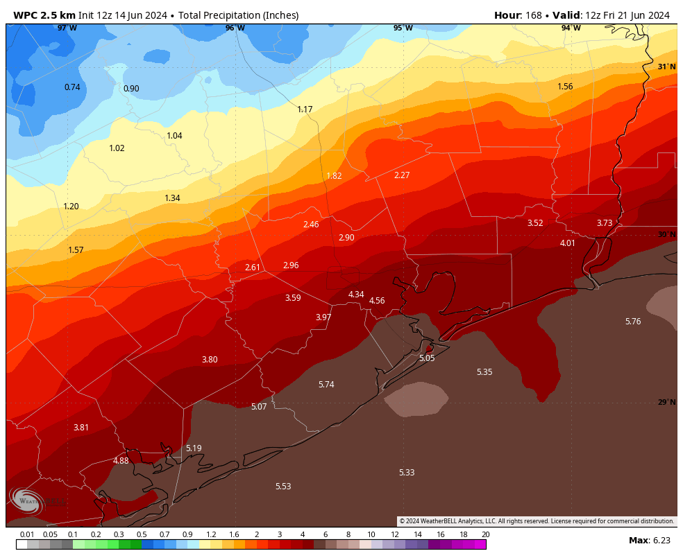
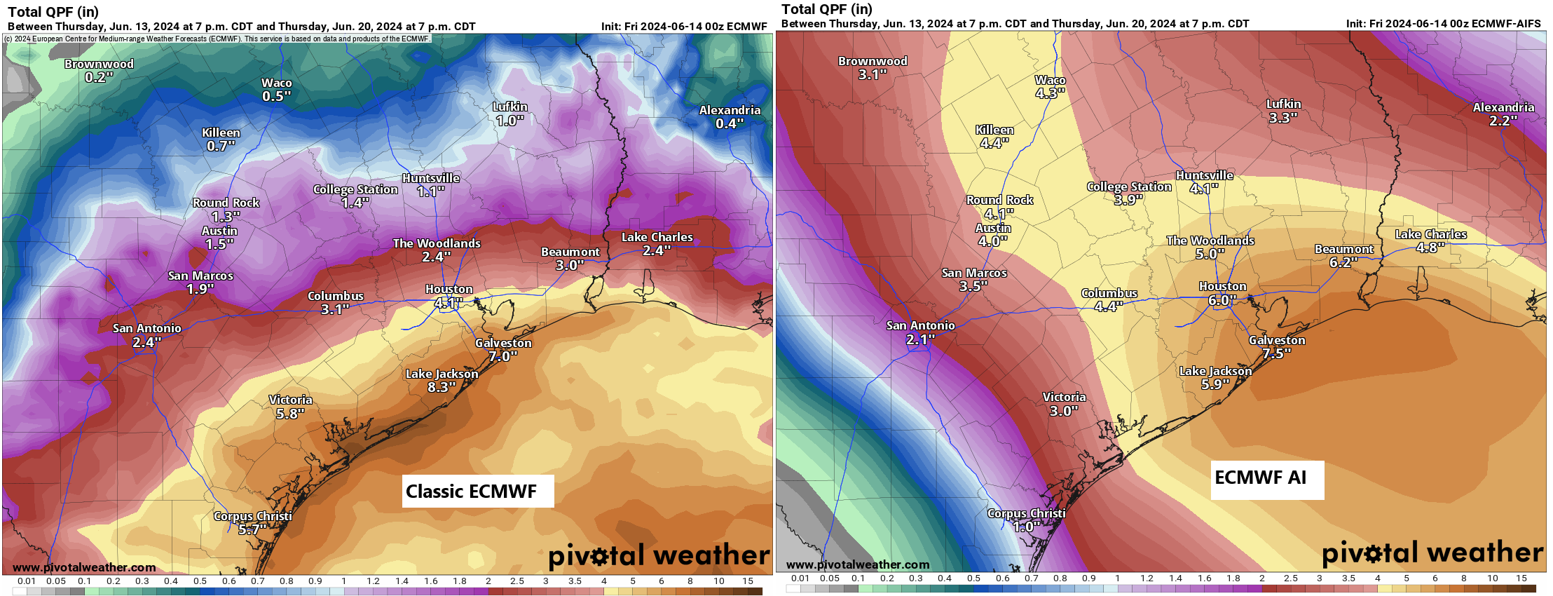
We are beginning to see decent model agreement that Tuesday night, Wednesday, and early Thursday will feature our highest rain chances, and with that will likely come some heavy rainfall. I think this is the timeframe where I would be watching closest for potential flash flooding. The trouble right now is that our models widely differ on where this occurs. Our typical physics-based models are focusing things on the entirety of the Texas coast, while our newer AI models favor Houston into Louisiana for the heaviest rainfall.
One other possibility in this scenario is that a lot of rain falls at the immediate coast or offshore, which ends up depriving inland areas of moisture. So there is at least a chance that we see a very sharp gradient of rainfall next week with high totals near Galveston and very manageable totals in Houston. Things should hopefully quiet down later Thursday and Friday, regardless.
Marine impacts
In addition to the rainfall, we will likely see some pretty considerable wind and wave impacts over the open waters next week. With rather sustained easterly or east-southeast 20 to 30 mph winds nearshore and 30 to 35 mph winds offshore, look for waves to begin to build to 8 to 10 feet over the Gulf by midweek. I would anticipate nuisance to minor tidal flooding issues as we hit high tide cycles on Wednesday and Thursday. We’ll want to keep tabs on this just because of the persistence of the onshore flow next week.
Bay of Campeche system
We continue to see about a 50/50 shot that a tropical system develops in the Bay of Campeche next week.

As noted above, this is related but separate from the rain we see next week. While development (low-end) is becoming more possible or likely, it is expected to quickly slide ashore in Mexico, so no direct impacts are expected on the Texas coast.
Beyond this, there may be another sloppy system that tries to develop the week of June 24th, but we have plenty of time to watch that. We’ll have more on next week’s rainfall situation over the weekend.

Until today, I was unaware that an AI version of the Euro model had been developed. So, I searched for a primer on the model. In my search results, I found an ars Technica article posted on June 3 by, you guessed it, Eric Berger! You guys are killing it!
Is that the EC-AIFS model that shows up on Tidbits?
Since AI requires a large dataset to forecast with some accuracy, I wonder, on comparison of the rainfall prediction maps, shown here (physical vs. AI) – is the AI data set skewed, showing more rain in the metroplex because there is way more data around Harris, Fort Bend, Montgomery, Galveston, than further south down the coast?
As predicted.
The lower temps it sounds like we’ll have will be nice regardless of whether we get rain!
How are you “processing” the new AI information? Since it’s new, I presume it has to prove reliability, but as another commenter noted – it’s been fed a LOT of data, so it might very well be valid. Sadly, for us locals, the difference between the two outcomes will determine our “planning” decisions. Traditional Euro means we can stay and merely monitor the situation, but AI Euro is leaning towards prepare for flooding. What do we do with this? Well, besides becoming extra anxious!
I recommend understanding that there is uncertainty in forecasts several days out, checking for forecast updates closer to the date, keeping calm, making plans, and making contingency plans.
Bring on the rain! Haven’t gotten a drop of rain in almost two weeks here north of Katy. Grass and trees are starting to get stressed like last summer.
For those doubting the Wesh2 news long range forecasting method, please note that the June 24 system is falling right into their hurricane forecast. The have East Louisiana through the Florida big bend highlighted followed by the Carolinas with potential dates of June June 24-29, August 10-16, and September 26-October 3. There are no guarantees ever of course. But if a low pressure system follows that path in that timeframe, I would hope it might at least raise a few eyebrows. It did for me the first few times – which is why I’m so passionate now about getting the word out since I’m convinced it works.
Until its 100% accurate in forecasting, there will always be doubt of long range models
Nothing in weather forecasting is perfect, but they’ve made a very significant advancement. The more widespread it’s usage, the more I can benefit from the results ;).
The GFS “modelcane” or “scar-i-cane” at the end of the month is now headed for the Florida panhandle as a strong tropical storm. So much for GFS long range.
The GFS is being skewed by the Central American Gyre right now. That’s part of the reason it’s so funky recently.
So it’s afraid of an ogre? I would be too.
hehe yeah, no fairytale trash messing up my perfect world
Well, crud. We have a family vacation to Cancun next Wednesday through Sunday. Do you think we should reschedule? Thanks for your insight!