In brief: Houston will continue to see plenty of sunshine for the foreseeable future, with temperatures continuing on an upward trend through the holiday weekend. Next Monday will be downright hot before a front arrives to provide some relief. We also take a look at increasing drought conditions in the metro area and offer a slight hope for some relief.
Drought returns
About one year ago, after the torrid summer of 2023, 100 percent of the Houston metro area was in at least a moderate drought, and for more than 90 percent of the region we were in a severe drought, according to data from the US Drought Monitor. Those conditions were wiped away after a wetter fall and winter, leaving the region completely drought-free for much of this year. Now that’s starting to change.
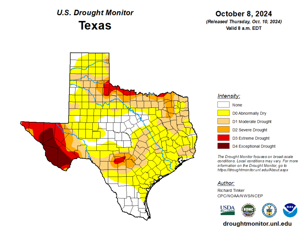
After dry conditions over the last couple of months, we’re starting to see drought conditions creep back into the area. About 70 percent of Liberty County, just to the east of Harris County, has now fallen into a moderate drought, and we’re seeing similar conditions to the northwest of Houston in Brazos County. Unfortunately, there won’t be much relief over the next several days. However there is a decent signal for rainfall about seven or eight days from now. We’ll see.
Friday
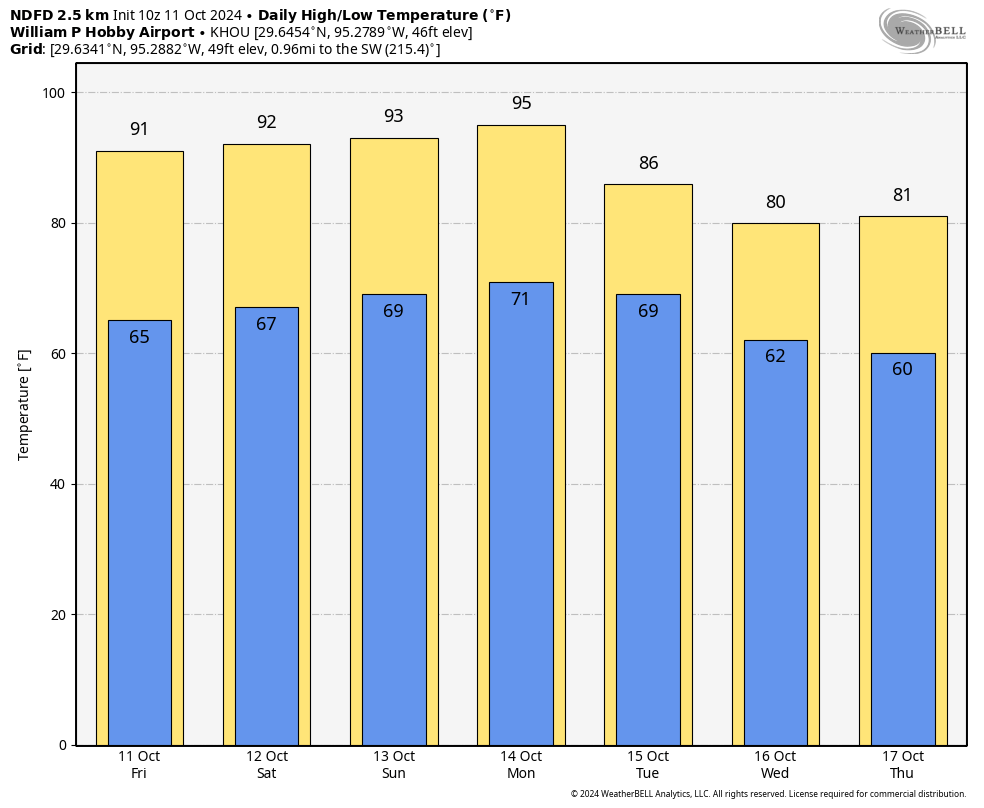
Skies today will be, you guessed it, completely sunny. We’ll see high temperatures of around 90 degrees for most of the metro area, with light northeast winds. Skies will be clear tonight—but alas, we think the northern lights that were visible in parts of the Houston region on Thursday night will be gone. Lows will fall into the mid-60s for most locations, with warmer conditions along the coast.
Saturday, Sunday, and Monday
It will be a hot and sunny holiday weekend as high pressure builds over the area. Look for highs in the lower 90s on Saturday and Sunday, pushing up into the mid-90s by Monday. Rain chances are effectively zero. The air will be a bit muggier, but it won’t be full on Houston humid. Winds will generally be light. Lows will drop to around 70 degrees.
Next week
As we’ve been discussing, some kind of front will arrive by around Tuesday, and thereafter we should see cooler days (probably in the lower 80s at least) and nights in the 50s or lower 60s. There’s likely no precipitation with the front, but rain chances do appear to be elevated beginning Friday and running into next weekend. Whether that means daily rain chances of 30 percent or 60 percent I cannot say. But since we’ve been so dry, it represents our best rain chances in quite some time.
Have a wonderful holiday weekend, everyone. We’ll see you on Monday.

That 95 is ridiculous.
I have a feeling it’s going to be high 80s, low 90s until December this year. Every year just gets worse and worse, and it’s only going to continue to get worse. This is my last few months in Houston. I’m counting down the days. Next year I will be enjoying a proper autumn again.
The link is broken
It’s supposed to be a link to the SCW posting from last night (Oct 10, 2024 at 7:04 pm) , titled “Tonight may offer a rare opportunity to see the northern lights in Southeast Texas”
It’s now fixed.
Of course the drought happens after the city resumes reading the water meters. >:(
I’ve suspected we’re in drought conditions, ’cos the doors in the front of the house are swinging freely and the doors in the back of the house are sticking, instead of the other way around…
Have you been watering your foundation through this drought period?
It’s a holiday weekend? Shoot.
Did I need to buy something for someone or hang a decoration or something?
Yes, for columbus day!!!
Will it continue to be dry through early November, or a become a wetter winter?
We would warmly welcome wetter wintry weather.
I have read that transition to La Niña has stalled….the ENSO is “neutral”. The NCEI data that I usually look at for the Pacific tropics SSTs seems to have been caught up in the Helene outage in Asheville NC. Sooo I’m not sure what to make of no rain since July and what that means for deep fall, winter, and 2025. Others here may have an educated guess. I tell you what tho: the climate in the Houston area for last 5 years has just been unpleasant and unpredictable. But most of the CONUS is abnormally dry or in drought now so it’s not just here.
Fall is cancelled this year. It will be 90s daily until it’s 50s daily. Forget the 70s and 80s, they will never happened this fall. This is the worst October I’ve ever seen here.
This is absolutely RIDICULOUS. I’ve had enough of heat, humidity, and hurricanes. I’m so glad I’m moving soon. This climate is absolute garbage and my family and I are sick of it.
Cycling through the Barker reservoir today it is disturbing to see how bone dry it is. The ditches along side the trail which usually have some water to attract the wild fowl are dry and cracking. Not good at all!
I’m so poor I have to hand water the yard/flowers. Drought + heat = no bueno ! High temps on the horizon still mostly mid to hi 80’s 🤔
no rain in the horizon?