We’d like to officially welcome you to early summer today. The next several days will feel more like later May or early June than early May. Not unheard of by any means, but certainly a change from what we’ve been experiencing much of the last month or so. The humidity is likely here for awhile. The heat may wane some eventually, thanks to a potentially wetter, stormier weather pattern in Texas.
Just a quick note on the hotter weather this weekend. Early season heat can be a little tougher on the body because we have not adapted to it yet, especially after such a comfortable spring. So please take it easy on yourself outside this weekend and practice heat safety.
Today
Some patchy fog may greet you out the door this morning, but short of that, it’s quiet. Much like yesterday, the sky may look threatening at times today, but most of the day will be fine. We’ll call it mostly cloudy with highs in the upper-80s, maybe near 90 in spots with enough sunshine. Storm chances this afternoon aren’t especially high, maybe on the order of 10 to 20 percent, but anyone that sees a storm later today could see some gusty winds, hail, legitimate downpours and lightning.
Saturday and Sunday
So, if you look at your phone’s weather app (including our own app!), it looks like this weekend is going to be miserably stormy. In reality, it’s not going to be that bad. Both days will feature a chance of showers or storms. But coverage of those storms is expected to be isolated. So plan for the chance of having your outdoor plans temporarily disrupted by storms, but I would not necessarily expect that to be the likely outcome. Sunday may carry a slightly higher chance of rain than Saturday, especially north of Houston.

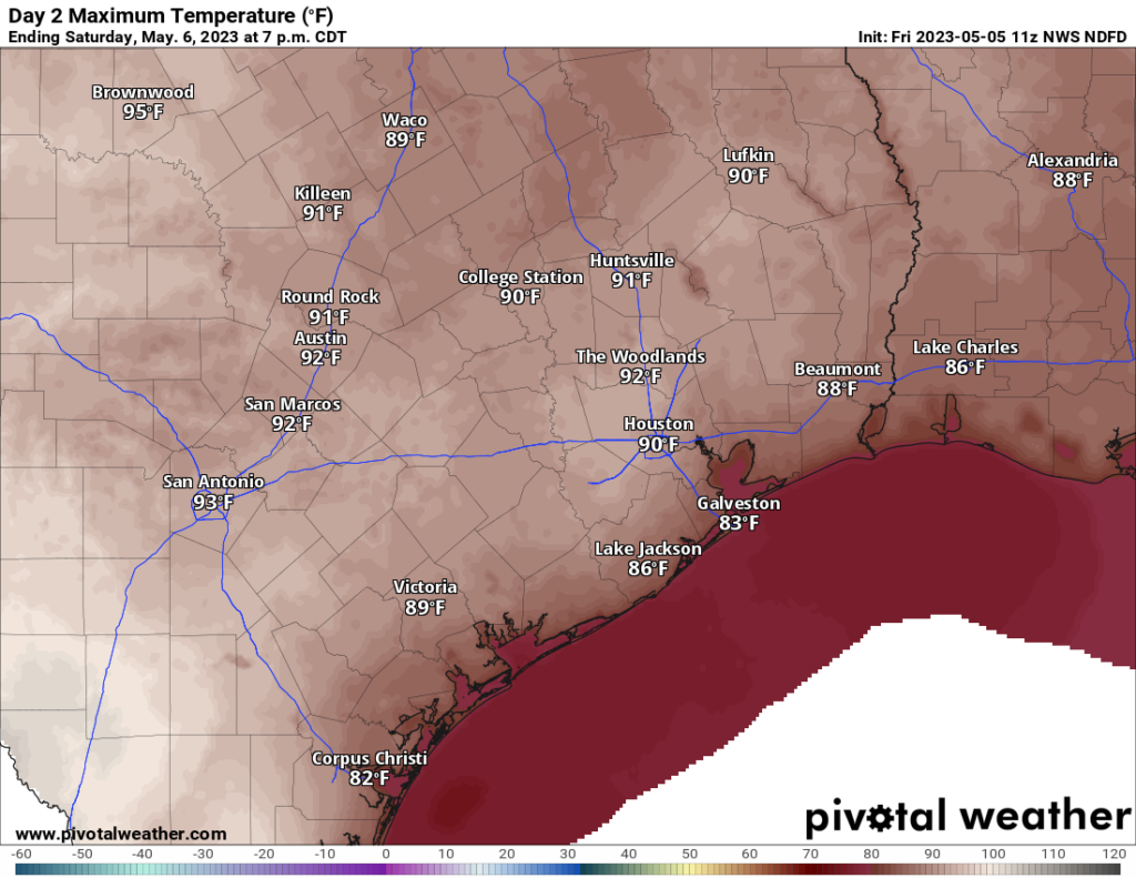
One thing I would plan on is hot weather. Saturday’s forecast highs are shown above, and Sunday won’t be much different. Expect upper-80s to low-90s and morning lows in the 70s. And plenty of humidity.
Next week
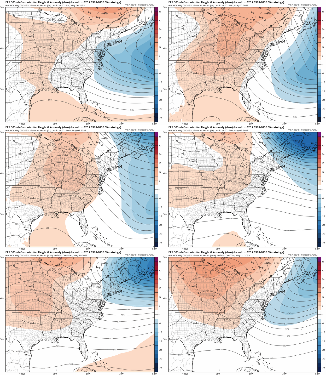
The pattern this weekend is going to feature a ridge of high pressure about 20,000 feet above us. Early next week, that ridge is going to break down. It will be replaced by more of a trough, a cutoff low pressure system, or something “flatter” over South Texas. In simple language: The pattern is likely to turn more unsettled with rain chances much of next week.

Given the difficulty with specifics, I would say we’d probably copy and paste a forecast of clouds, sun, a 30 to 40 percent chance of rain each day, highs well into the 80s, and lows in the 70s.
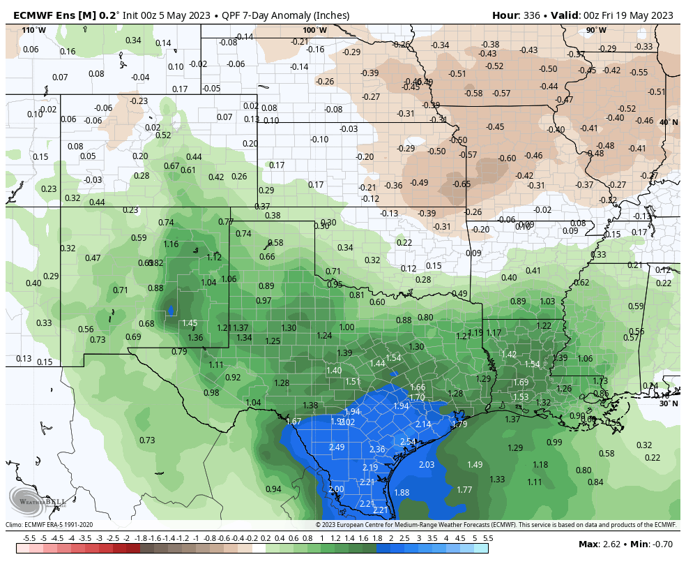
The wetter pattern is expected to stick in Texas, with models forecasting above average rain over Texas for the next 2 weeks. The map below shows the days 8 to 14 forecast rainfall anomaly from the European ensemble mean.

We’ll see if that’s the case, but if you’ve been seeking some added rainfall this spring, you may get your wishes granted.


Hello, do you have your own app?
There’s literally a giant GET THE APP link in the sidebar, my dude
Which weather app shows stormy for the weekend? My Weather Underground forecast is in line with your isolated 20-30 percent rain chance and low 90’s.
That’s okay, Dean, I seldom pay attention to sidebars either! So much to read, so little time 😎
Is the +2.54” anomaly an ominous figure? Looks like a big number to me, but I’ve never seen this kind of graph before.
Not ominous…pretty standard for a 7-day period that’s wetter than normal. We’ve got some room for water.
Actually, spring was beautiful this year, it lasted quite a bit. I really enoyed it. These guys are always whining about heat and summer, it’s annoying. This is the south. It’s hot here. Id be more interested in explanations for the bad rain forecasts. All last week there was rain forecasted this week and we have been dry. Then it rains out of the blue. All I always hear is “our forecasts are more accurate than ever” blah blah blah. There is always room for improvement.
What in the world are you talking about?
Here is everything they said last week even remotely connected to rain this week:
On Monday:”The start of next week should see a warming trend, with temperatures eventually getting into the mid- to upper-80s, probably. Then? Perhaps some sort of front to cool things down. We’ll see.”
On Wednesday: “It looks like the next chance of rain will return on Tuesday or Wednesday.”
On Thursday: “While there will be some clouds, I don’t see any major indications for storms or rainfall.”
On Friday: “Shower chances will return by then as well but right now no day looks to have particularly impressive rain chances.”
The rain forecasts are fine. I followed closely. Always understood it was hit and miss. One reader reported 4.6” for April, about 4” more than I got. Sooo, I finally broke down and dropped 2” of awful treated city water on my yard this morning. Had to. Stuff was withering. Too much stress coming with this heat. The Hobby monitor is 10.5” rain deficit for the year. I’m reconciling myself to one more summer drought. But like they say… “we’ll see”
Houston water is so hard that if it was any harder they’d be delivering it to us in blocks on the back of a truck.
It already feels awful outside. 85 with a dewpoint of 74. Heat index is at 93. Saldy this is just a precursor of what’s to come. Hurry up November lol
Driving down Westheimer half an hour ago my car thermometer was reading 94F.