In brief: Today’s forecast looks ahead to warm and windy weather for the next couple of days, followed by a potentially rainy Easter Sunday. With two major sporting events taking place in the Houston region nine days from now, the MS 150 and IRONMAN Texas events, we also take a look at likely conditions for next weekend.
MS 150 ride and IRONMAN Texas
This morning we are taking a look ahead to the weekend of April 26, when there are two major outdoor events in which thousands of people will be exerting themselves outside in the elements. The first of these is the MS 150 ride on Saturday (from Houston to LaGrange) and Sunday (from LaGrange to College Station). The second is IRONMAN Texas, a swim, run, and cycling event in and around The Woodlands on Saturday.
Much of next week should see a decent chance of rain showers, but by next weekend this overall active pattern appears to settle down. So I’d peg rain chances at 20 percent, or less. The usual caveats apply to a forecast nearly 10 days out, but at this point I don’t see much evidence of a cool front arriving by next Saturday to shake things up. Therefore I think the most likely forecast is for temperatures in the mid-80s.
Unfortunately (especially for the triathletes) conditions look somewhat to very humid by next Saturday, and almost certainly we’re not going to see dewpoints in the 50s which would be more comfortable for outdoor exertions. In terms of winds we probably are looking at southerly or southeasterly winds, although how strong they will be is anyone’s guess. This is good news for the MS 150 riders, and for about half of the route triathletes will be taking during their cycling event. Good luck to all.
Thursday
Temperatures this morning are in the upper 60s across much of Houston, with dewpoints nearly to match. The mercury is headed into the mid-80s this afternoon beneath partly sunny skies, with partly sunny skies. As we have been saying, the story of the end of the week will be gusty southerly winds. We can expect breezy conditions for today, Friday, and Saturday, with gusts from the south up to about 30 mph, and possibly higher. Lows tonight will only drop to about 70 degrees.
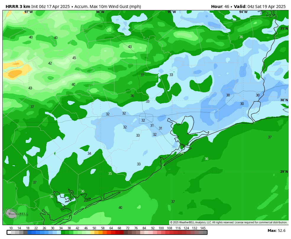
Friday
I expect more clear skies to start the day on Friday, but things should cloud up at some point during the afternoon or evening hours. Depending on cloud cover, I think there’s a good chance that temperatures push into the upper 80s, with a few locations possibly hitting 90 degrees. So, pretty warm. And don’t forget about the gusty southerly winds. Coastal areas have a chance to see some light showers later on. Expect another warm night.
Saturday
This will be a cloudy and humid day, with high temperatures in the mid- to upper-80s. Again coastal areas should see a slight chance of rain, but the likelihood of rain for inland areas is probably 10 percent or less. Rain chances increase a bit during the overnight hours.
Easter Sunday
An approaching front will help drive a healthy chance of rain showers on Sunday, probably 50 percent or higher. We also have to consider the possibility of some thunderstorms, depending on the movement of the front. Right now various model solutions have the potential for several thunderstorms in east, or northeast, or central Houston. So Sunday’s weather is kind of like opening an Easter egg at your Aunt’s house. You never quite know what you’re going to find in there. My sense is that most areas will see the potential for some light rain during the morning hours, with better chances and the possibility of thunderstorms during the afternoon and evening hours. To be clear, I expect much of Houston to pick up a quarter of an inch of rain, or less. But there is the risk for higher amounts in some areas. Expect highs in the mid-80s, otherwise, with plenty of humidity.
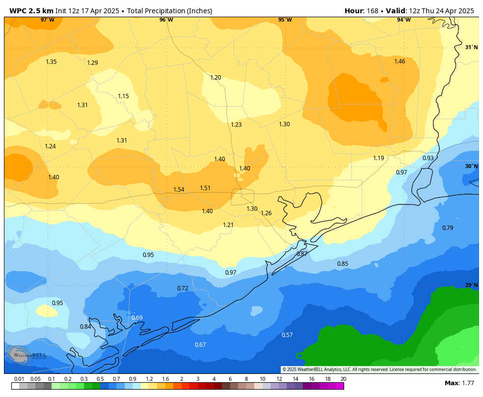
Next week
The aforementioned front will probably move into the Houston region and peter out. This means we might see some slightly cooler weather on Sunday night or Monday. Rain chances fall back a bit before increasing again on Wednesday or Thursday. I’m hopeful that by the end of next week much of the area will have received 1 to 2 inches of of rain to help keep things green outside. Highs should remain in the 80s with plenty of humidity next week.

To your best estimation, how windy should we expect Saturday morning to be?
According to the Weather Channel, in the Bush Airport zip code area, on Satuday, winds will be 7 to 16 miles per hour with wind gusts up to 30 m.p.h. I hope that helps.
Thank you!
Hey there, I was wondering why you close comments on old posts—probably because it’s hard to keep up with them? Anyway I’m a regular reader but we were just reminiscing on our first few months living in Houston and I was telling my mom I remembered being in an awful storm. It’s literally my first memory. I was 3 and we’d just moved to 7979 Westheimer, it was right before Thanksgiving. I had nightmares about multiple tornadoes for years so I thought it was just a recurring dream. In conversation my mom confirmed “no…there was a tornado outbreak. We’d just moved from Bartlesville and I couldn’t believe our luck.”
And then we found your article on the November 1992 outbreak! The house we eventually moved into that I spent 14 years in was just a couple blocks from the parts of Kelliwood that took the brunt of the F2 in Katy.
I’ve only ever seen 1 tornado in my life with my own two eyes. We were pulling backward out of the garage down our driveway to head to the grocery store. As we pulled further away from the house, a funnel came into view as the garage blocked less of the sky out. Utter silence while my dad threw it into drive and we ran into the powder room to shelter.
Thanks for jogging our collective memory. I still have the Kermit doll I clutched in terror that night of the outbreak lol
We need more rain than that.
Rainfall currently 3” below normal. Model slightly different from 2 days ago. Where there was precip Su, W, F next week with the Mexico ridge solidly headed east •• not so much now. We’ll see if that holds – still out there on the confidence level. The summer Bermuda ridge seems to be extending west in the latest, guiding trough movement up and away. I know this is frustrating for rain lovers.