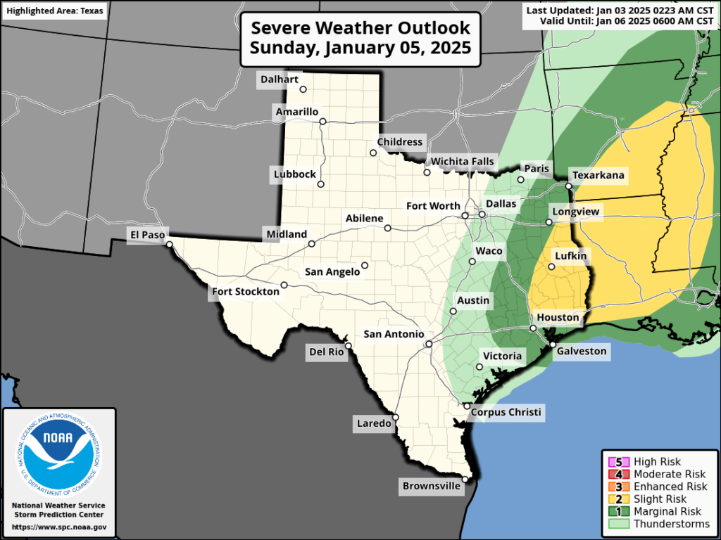
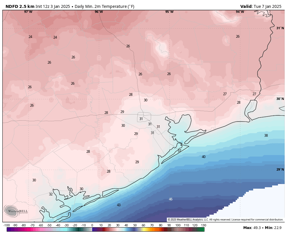
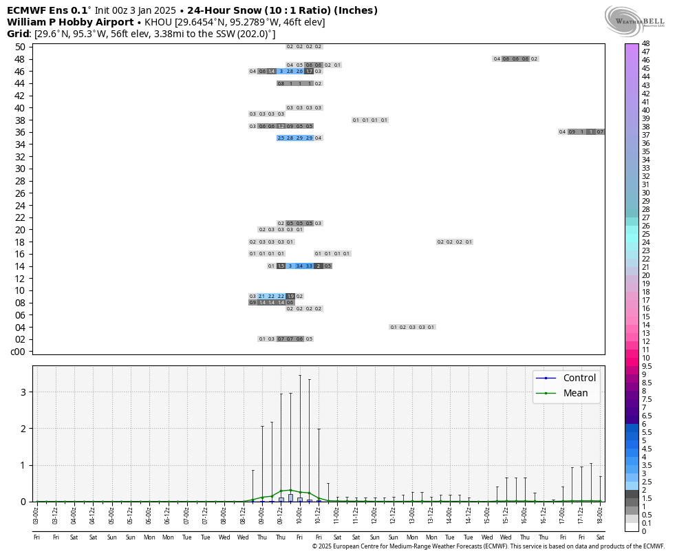
In brief: Houston will experience milder conditions until a robust front arrives on Sunday, with the possibility of some severe weather to the northeast of the city as it passes. Afterward we’ll see blustery conditions, with the likelihood of light freezes and, by Wednesday night or so, even the potential for some sleet or snow.
Friday
There’s some light drizzle at a few locations around Houston this morning, but this should soon clear out. We’ll be left with a partly to mostly cloudy day, and high temperatures in the upper 60s or so. Winds will be light from the northwest and temperatures tonight will drop into the upper 50s.
Saturday
A similar day to Friday, albeit a little bit more humid, perhaps a little more sunshine, and a little warmer. Expect highs in the mid-70s. Saturday night will be quite a bit warmer, with lows only dropping into the mid-60s. If you are looking for a mild evening outdoors, this is it.

Sunday
Sunday will start out warm, and high temperatures will likely reach the lower- to possibly mid-70s before a front comes sweeping down from the northwest. The timing remains a bit uncertain, but this is likely to occur during the afternoon hours. It looks as though a line of broken showers and thunderstorms will accompany the front’s passage, with the greater likelihood of rain, and possibly severe winds, to the north and east of Houston.
Temperatures will drop rapidly behind the front, as brisk northwesterly winds bring in much drier and cooler air. By early Monday morning much of the region will experience a light freeze, with temperatures dropping into the 30 to 35 degree range for most of the metro area.
Monday and Tuesday
This period will bring us our coldest weather of the season, to date. Look for high temperatures in the 40s, with sunny skies. The clear skies will allow for ideal cooling overnight, with temperatures dropping to around 30 degrees in Houston, give or take. We still don’t have a concrete handle on how cold things will get, but I continue to lean toward a “light” freeze rather than a “hard” freeze. This will be less impactful on our infrastructure, but please do keep pets and plants protected during this cold spell.

Wednesday and Thursday
Temperatures remain cold during the latter half of the week, and we’ll need to keep our eyes on a coastal low pressure system that could bring some decent precipitation chances, especially on Wednesday night and Thursday. Depending on whether this system delivers, and how cold temperatures get, we could see some sort of sleet, snow, or other wintry precipitation on Wednesday night or Thursday morning. Saying precisely what, or how much, is impossible this far out. The bottom line is that if you have plans for Thursday they could be a little messy. We’ll see.

Later next week
Temperatures begin to moderate somewhat heading into next weekend, although we still look cool for this time of year, with highs in the 50s and lows perhaps in the upper 30s, give or take. Winter, for the next week at least, is going to feel like winter around here.

Why, over just the past few years, are weather forcasters putting “tomorrow’s” low temperature as “today’s” low? I understand you’re trying to say when we wake up that’s the expected temperature, but it’s misleading. When I read your 5 day forecast it clearly states this Sunday Jan 5th the low will be 28 … that’s wrong. 28 degrees won’t be reached until after midnight on Jan 6th.
Is the intent for people to quit trusting the weather service? Or is it just the lowest level of intelligence you’re trying to reach?
As someone who doesn’t trust the weather service and is of the lowest level of intelligence, I would say yes.
“Low temperature” is not the same as “temperature when you get out of bed in the morning” although it usually works out that way. If the lowest temperature in a midnight-to-midnight day is 28, it’s 28. It doesn’t matter what time that occurs.
I assume you are referring to the SCW app forecast. Technically, they are saying Sunday night, which commonly encompasses sundown to sunrise on Monday. If you go to the NWS website, this would be written out, but on the SCW app, it is just an image. Most people refer to the period before they wake up as the prior night, even though this isn’t entirely correct as it is split between two different days. And writing out “Sunday night/Monday morning” would be a bit long-winded. It is a bit like defining winters……are we in the winter of 2024 or the winter of 2025? Since winter encompasses both years, you could say either one, but apparently, we would define it as the Winter of 2024 since it began during 2024, even though most of the period is in 2025.
Well, that is my two cents on the matter.
Evelyn, you must be a lot of fun at parties.
Also, we lower level of intelligence folks probably think of midnight as belonging to the end of the previous day.
But if the low for Jan 5. Occurs at 11:59 pm and is 28 degrees, that is the low for Jan 5. And one minute later it’s still 28 degrees. So that also can be the low for Jan 6. The temperature doesn’t know what time it is.
Wow! 🙄
I’ve noticed that the NOAA scale seems to cap out at tier 3 and ‘Slight’ Apparently means 6 Tornadoes in Texas.
Between severe weather sunday, freezing temps the next few days and freezing rain later in the week my return to work is going to suck.
I wish it was possible for the weather in this state to not always have to be an event.
I don’t trust the weather to be stable anymore. I’m so scared of this Spring it steals my breath. I can’t even think about ‘hurricane season’, I’m very concerned with ‘Spring Tornado Wind Season’.
We’ll need to leave this area as soon as we can manage it. Get S of I-10.
I used to really enjoy storms. Not anymore.
Tornados are really small and significantly affect a small sample size of people even in areas where they are prevalent like Oklahoma. They look scary but aren’t very big and rarely cause a lot of damage/loss of life.
Also, even a tornado warning right on top of your head does not mean there’s a tornado. It’s extremely unlikely you will be in the path of a Tornado this spring; I would worry more about the hurricanes.
Also weren’t a couple of the tornados this past week south of I-10…?
Yes, there were a few S of I-10 – but the infrastructure is better in Ft Bend (grew up there).
They haven’t historically caused a lot of damage here, which is why I thought it might ok to live in Spring for work. But since 2023, I have witnessed several tornados up here and now been in two. (I think) that F3 last week started near us – all that whistling.
North Hou/Spring/Woodlands is in a growing clash zone that’s becoming more pronounced every year – every five miles N of 99 up here seems to make a difference in intensity. It’s like having a radar addiction during the storms, seeing those temperature differentials, realizing too late the mistake I made moving us up here. I’ll never blindly trust a roof to hold again.
Every time there’s a strong wind, the power threatens to go up here at the edge of Montgomery County, and the streets aren’t built for drainage. Feels so vunerable.
The physics of it, and the tornados are changing.
I sure hope you’re right about this Spring 🤞🏻
Pets should be protected for sure.
Protect sensitive plants but covering the entirety of plants is not warranted. The best thing to do is keep plants watered and they will be fine. Winter flowers are made for cold temps…..
By accident, came across an article last night at “Livescience dot com”, titled:
Polar vortex could bring dea dly winter storms and coldest weather in more than a decade to US.
They include an 8-14 Day (Jan 9-15) Temp Outlook map from NOAA, showing somewhat drastic temp drops, the majority happening in the mid-(& south)-eastern US, including FL. It’s mentioned this could be the coldest Jan since 2014.
Well, gonna get the SUV inspected this AM, before the cold events usher in.
Definitely get your vehicle looked after. I had ours in the shop.yesterday and the antifreeze had separated. It just happens sometimes.
Yuck. Bring back the 70’s.
“In brief: Houston will experience milder conditions until a robust front arrives on Sunday, with the possibility of some severe weather to the northeast of the city as it passes.”
“It looks as though a line of broken showers and thunderstorms will accompany the front’s passage, with the greater likelihood of rain, and possibly severe winds, to the north and east of Houston.”
I’d prepare for tornados Sunday again just like last week. You’ve all been warned. Prediction and accuracy is no longer a given anymore.
Severe weather and the possibility of tornadoes were forecast and warned about last week. I’ll keep trusting SCW, thank you.
Is anyone in central/Houston metro wrapping pipes for this or is that not needed?
I’m wrapping those pipes. Uri brought 3 days of no power or water, and when it came back on, 3 broken pipes that cost a LOT to fix. I would rather not have to do that again.
Is Sunday’s severe setup different from last week’s ? Or, are the same antecedent conditions that aligned during last week’s catastrophe going to be present again?
What do we think about bringing in plants in pots this time?
If the forecast is below 34-33, I bring in potted plants. Temps often drop a degree or two more than they forecast. Since this is multiple days of below 32 for me, I’m definitely bringing in potted plants.
Thanks for the suggestion! 🪴
I’m bringing my little aloes in 🌱 💗 🌱
Houston doesn’t get snow, they get freezing rain. I once saw snow in Colorado with temperature of 37 degrees, but nope not Houston…apparently it has to get down to -15 degrees here.
Most of Colorado’s elevation is significantly higher than Houston. The atmosphere becomes less dense as altitude increases to the order of -1in HG/1,000 gained (air mass saturates much quicker in less dense air). With a ~5,280 linear feet delta between Denver and Houston and many more layers of air masses for snow/winter precip to turn into rain on its way to the Houston ground vs mountainous terrain are the main factors in the large temp difference needed for snow between the locations. It’s not uncommon for mountains 9,000ft MSL and above to get snow in near 40 degrees temps.
The best “snow year” in Houston that I know of was 1973. January, February and March each had a measurable snowfall inside the Loop that year.
I know right. My science teacher always said it never snows cause we need freezing temps and precipitation at the same time, and that just hardly ever happens. Then it finally does happen, and still no snow! Like the last 3 times all ice storms, even in 2021.
What usually ends up happening is a thin layer of warmer air above freezing will drift over the mid levels of the atmosphere in our region and melts the snow into liquid water. The temperature drops back below freezing in the lower levels of the atmosphere, which refreezes the water into ice pellets instead of snow when it hits the ground.
This temperature inversion is basically the same thing that causes our cap inversions, warm air from the desert mountain platue in Mexico.
You’re so good at this ☺️
It can snow in the Houston area without surface temperatures being below freezing. I’ve seen it multiple times.
We had the nicest snowfall the night of Uri, I remember staying up late watching because it was so enchanting…and then I woke up the next morning to the first of 3 days without power…
I loathe the wobbly polar vortex. 99% of time we’re zone 10 inside the beltway. Otherwise we’re zone 8-9. Bananas, gingers, split leaf philodendron, bougainvillea will collapse in low 30s. What a mess to clean up. Palms mostly good to 25. Desert rose needs to come in. The potted impatiens will come inside too. Cold air advection is the enemy. Urban island effect helps the radiative heat loss. Do all this Sunday – one last warm rain. I guess I’ll secure the exposed pipe but hard freeze unlikely in Harris. Montgomery north not so sure.
Stop being dramatic. Nothing you mentioned is going to collapse in the low 30s or even the high 20s. The banana stems are not going to freeze from this event. Just going to be mostly cosmetic damage from frost on the leaves. Same for bouganvilIea. Shell ginger and split leaf philo won’t skip a beat. I grow tons of tropical plants and palms from the other side of the world in west Houston. This is not shaping up to be a concerning freeze event and I have not protected anything aside from an exposed mango tree. Everything else will survive under oak canopy.
Ok! Good. You made my day. Would like one season where just maybe I don’t have to cut everything back and wait for regrow from the ground. Maybe this winter is the one.
It looks like we are finally about to get our allotted one week of winter next week. For those of you who love the warmer weather, enjoy Sunday.