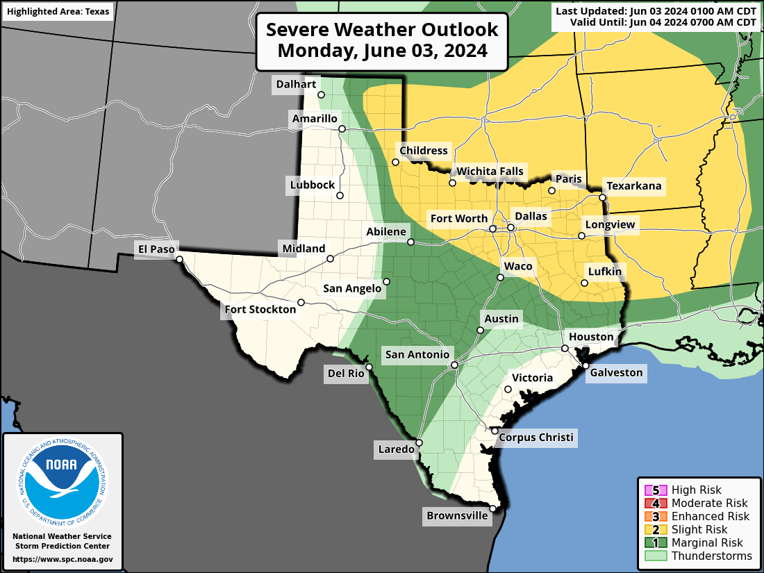
In brief: This post recaps the macro conditions that set the stage for our strong to extreme storms during the month of May. The week ahead looks warmer, with highs in the low- to mid-90s, but possibly some slightly lower humidity by the weekend. Rain chances are low for awhile.
May storms
The month of May ended over the weekend, and in Houston we will remember it as one of the stormiest spring months in memory. I don’t have all of the answers for why strong storm system, after storm system rolled through Houston bringing violent winds, some hail, and occasionally some tornadoes. But as we look how the month of May ranked, temperature-wise, we can glean one big clue.
For the Houston area, the month generally ranked among the 10 warmest Mays on record. However, when we look at the western United States, particularly Colorado and Wyoming, we see colder temperatures. This is important because storm systems that develop in the Great Plains states, and then sweep eastward and southward, are driven by both geography—where the mountains meet the plains—as well as temperatures. That is, the collision of warm, humid air from the Gulf of Mexico with the colder air of the northwest United States is the cauldron in which mesoscale convective systems are born. This May, that temperature gradient was sharper, creating an environment in which the clash of these air masses produced still more violent storms.
Monday
Today will be similar to Sunday, which is to say that skies will be partly sunny with high temperatures generally in the low 90s. Winds will be from the south at 10 to 15 mph, with higher gusts. Houston isn’t entirely out of storm territory, but anything that develops in Houston should be isolated, and rain chances are likely only about 10 percent. Further north, along and north of Highway 105, storm chances this afternoon and evening are a bit higher. Tonight will be warm, with lows only briefly reaching the upper 70s for most locations.
Tuesday
Skies will be mostly sunny on Tuesday, with highs in the low 90s. There’s a bit of uncertainty, as there are hints of another modestly organized storm system in the models approaching the city on Tuesday morning. However, I’m fairly bearish on this actually happening, so I expect we’ll remain dry. But it’s possible we’ll see a few showers and thunderstorms during the morning hours. Winds will again be from the south, but perhaps gustier, up to 25 mph or so.
Wednesday, Thursday, and Friday
These will be warmer and sunny days, with highs in the mid-90s. Do you like summer in Houston? Then you’re in luck. Rain chances aren’t zero, but they’re on the order of 10 percent each day.
Saturday and Sunday
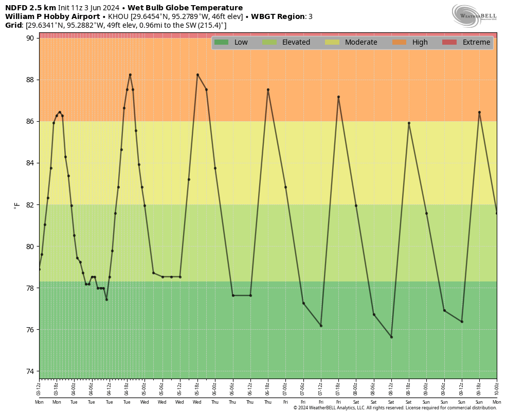
A slightly drier air mass may work its way into the region this weekend. Highs are likely to still reach the mid-90s, but the humidity may be slightly lower. (You can see this reflected in the wet bulb globe temperature forecast for the weekend). Lows should get down into the mid-70s in parts of Houston, so the evenings may feel that bit more comfortable.
Next week
I don’t feel particularly confident in the forecast next week, but some rain chances may return to the forecast by Monday or Tuesday. Nothing crazy, mind you. But after a sunny week and weekend, some rain probably would not be unwelcome.

I never thought I would say this but after last summers crazy heat and this springs intense storms I am ready for a typical Houston summer. Hot and humid with a high of 93 and a 20% chance of afternoon storms. I guess you don’t really know what you have until it’s gone!
That mention of the slightly lower humidity this weekend makes me think of the rival energy provider’s commercials where the “holdover” family’s mom says: “Ooh, it’s dropping” when the teen daughter says that the indoor temp is now 95 degrees. (Yes, I see this commercial way too much on streaming TV.)
I don’t say it too often but I’m jealous of Wyoming and Colorado for having a below-normal May temperature. Would they consider taking 15 degrees daily from us for free?
While Hobby Airport only had its 4th warmest May in terms of average temperature, it had the warmest May on record for low (nighttime) temperatures.
Yeah… SCW had a post about this last year, but records for warmest lows are likely to continue for the foreseeable future due to increased urbanization and population growth in the Houston metro. Gone are the days of getting low 70s in the early morning during the summer.
As well as mosquito-free mornings. They are really bitey in the morning.
I think low nighttime temperatures are a function of the urban heat island effect with all the concrete holding warmth. It’s probably a sign of the times as Houston has grown so much over the last 40 years.
The Urban heat island definitely plays a role but even at rural stations here in Matagorda and Brazoria county summer nights have been averaging warmer than they used to
Yep that is in large part due to a strong positive Artcic Oscillation that kept the cool and dry air north of our region throughout most of the month. An abnormally warm Gulf along with a constant onshore wind also kept overnight temperatures warm.
Going into summer, I’m curious how we are looking from a rainfall perspective. How much did this spring dent the draught from last year?
We are not in a drought, as is most of East Tx, haven’t been for several months. West Tx however, especially hill country is still in D3 severe drought, in fact canyon lake is at it’s lowest level ever, so they could really use the rain.
Cycling around Fredericksburg a few weeks ago I was stunned at how many groves of trees were withered away. It is looking very much like a desert climate there now.
Man you’re not kidding… Kendall County (San Antonio suburbs but not all the way to Fredericksburg) has been in D3 or D4 drought conditions for like 2 years straight now
https://droughtmonitor.unl.edu/CurrentMap/StateDroughtMonitor.aspx?fips_48259
Has the heat dome over Mexico disappated? I thought I read somewhere (KHOU or KTRK can’t remember) that was the reason we were getting all these storms?
The high pressure dome is starting to move our way – hence the shift to hot and dry conditions over the next week or two.
Seems odd to me that in Mexico, right where that dome of high pressure is, on the U.S. surface map there is a surface low and a good amount of rain. Why don’t we get this when a dome of high pressure is over us?
Are those shortwaves like little stormy seed packets floating around, looking for warm moist air to start trouble?
Short waves are perturbations in the large scale (synoptic) flow. They are small “wrinkles” that can produce sufficient kinematics (lift), in combination with the proper thermodynamics to create storms.
Watch some of Trey Greenwood’s YouTube videos (Convective Chronicles) where he is covering the large scale pattern. He does a great job of highlighting shortwaves within the overall flow. I believe he also has a video tutorial series that covers this, among other topics.
Maybe not weather related, but does anyone else have caterpillar-maggedon on their trees? Little green ones, that may be webworms? They have attacked my mom’s house and have spun webs all over the place. I thought they were spiders, and when I figured out they weren’t, I thought they might have come out due to the rain.
I’m from here, and I’ve never seen any of these before. Yuck.
Those can be either salt marsh or yellow woolly bear caterpillars. No need to spray the trees. Just open the webs with a long stick so birds and lizards can get at’em. Do this early before they spread to higher branches. If the trees are healthy they can survive and will regrow their leaves.
I’m in Tyler but moved from Houston (in 2020) and still follow this site because I love it. I’ve noticed a few slugs on sidewalks in my neighborhood over the past couple of days. Really grateful for this site.
They’re webworms. They’ve swarmed both my mulberries and vehicles, and were blown around onesie twosie against the house and across the yard after the storms. I asked my arborist about them and he said they’re more widespread and plentiful than in previous years. I’m chalking it to another drought-to-wet conversion because IIRC we had a bye year of them last year. The rain took out the ones on the trees and new leaves are already emerging.
I hope we don’t get another heat dome no rain situation…
and now we have “gorilla” hale to go with the high winds & rain – so is this the result of all the geo engineering going on in Colorado or God’s way of smashing all the solar farms
Right, because “God” cares about such things.
What is truly astounding is that the city authorities do not appear to have any plan in place that even acknowledges Houston is entering into a dangerous climatic trend, or that the city should change its ‘concrete forever’ policies. Recently, a piece of ground near Herman Park described by the city as ‘waste land’ became vacant and landscape designers were employed by the city to ‘re-vision’, it resulting in more than half this tract being covered in a non-permiable material. It’s ridiculous.
That would require acknowledging that climate change is a real thing and would interfere with their ‘own the libs’ policy.
Do you like summer ⛱️🌞 in Houston?
Lolol 😆 I chuckled… It may seem crazy growing up in DFW, I ABSOLUTELY ADORE HOUSTON weather. Hurricane 🌀 Ike and all 🎉👏🏽🥳
as long as we get rain I am good. Droughts are horrible here