In brief: In today’s post we discuss lower rain chances for the rest of the work week, before an uptick this weekend. Also, we take a deeper look at an updated forecast for the remainder of the Atlantic hurricane season, which has had a sneakily impactful start.
2025 Atlantic hurricane season
So far this Atlantic hurricane season has been a non-event for the greater Houston area. However two of the storms that have developed this season have created significant impacts elsewhere. Most everyone reading this is familiar with the catastrophic flooding in the Texas Hill Country last weekend. This was driven by the remnants of Tropical Storm Barry, which made landfall near Tampico, Mexico and then wandered around before stalling over Texas. Then, Tropical Storm Chantal made landfall in South Carolina on July 6, and brought record flooding to parts of North Carolina a few days ago.
Therefore, while we have not had any hurricanes yet (which is normal) this has been an impactful season overall so far. On Wednesday forecasters at Colorado State University released an updated forecast for the 2025 season, and they slightly lowered their total of named storms (17 to 16) and hurricanes (9 to 8) as part of this update. “The primary reason for the slight decrease in the outlook is both observed and predicted high levels of Caribbean shear,” the forecasters stated. “High levels of Caribbean shear in June/July are typically associated with less active hurricane seasons.”
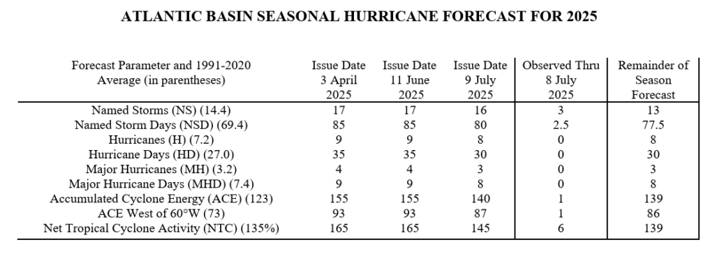
While this ostensibly good news, we have already seen in the last 10 days that even relatively weak tropical systems can cause significant problems, both in terms of damage and loss of life. And given the overall accuracy of seasonal forecasts, a slight modification like this is more or less “in the noise.” The reality is that, for Houston, prime time for hurricane season will come in August and September, so we are still in the very early innings.
Thursday and Friday
Unlike the last couple of days, we are not seeing much shower activity offshore this morning. That’s partly because the level of moisture in the atmosphere is a little bit lower. This should lead to fewer clouds today and Friday, along with less coverage of showers and thunderstorms. Overall rain chances are probably about 30 percent. However, where there is rain it could be briefly intense, as there is still the potential for isolated strong storms. Because we will see more sunshine, the Houston area can expect temperatures to rise into the low- to mid-90s, so a little bit warmer than the last couple of days. Winds will be from the south, and may be a bit gusty on Friday afternoon.
Saturday and Sunday
Slightly higher moisture levels, in addition to a more supportive atmosphere, will lead to increased rain chances this weekend. I’d put them at about 60 percent for both days. Overall accumulations for most locations will probably be in the low tenths of an inch, but we could see a few bullseyes of 1 inch or more. With a few more clouds we can probably expect high temperatures for most locations to top out in the lower 90s, but it will still be plenty humid with muggy nights.
Next week
Some rain chances will probably linger into early next week, but then I expect mostly sunny conditions for most of next week. High temperatures in the mid- to upper-90s are likely, but I would not lock them in quite yet. Regardless, I do think it’s going to feel close to full-on summer out there for Houston so steel thyselves.

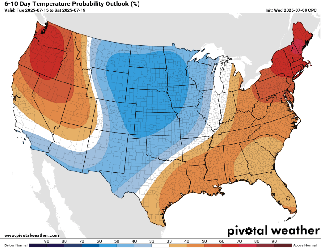
Does anybody understand the Temperature Probability Outlook % map? Houston is clearly in the orange, and legend says “40-50%” above normal. So if normal is 80°, does that mean it’s going to be 120°? Of course, that can’t be right. Could anybody here explain this to me? Thanks!
This information was copied from the NOAA website:
CPC’s 6-10 day and 8-14 day temperature maps show the probability of the observed temperature (the average of the daily mean temperature of all the days in the period) will be in one of three different categories: above normal, near normal and below normal.
These maps show the probability of the 6-10 Day and 8-14 Day Average Temperature being above, near and below the 1991-2020 climate normal for the period.
You can check it out for yourself. I don’t think I can link a website in this comment without getting blocked from commenting by cloudfare
Cachiva, it’s a 40-50% CHANCE that the temps will be above normal. It’s not a temperature measurement. I can safely say it will not reach 120° in the next few weeks. It will probably just be a degree or two above normal.
It is a probability map. It indicates the odds of higher or lower temperatures than normal. You are reading that there is 4 in 10 (40 in 100) chances for higher temps than the normal.
As a character in a Noel Coward play says: “I don’t know what normal is any more”, and neither do I, so I think showing charts indicating deviations from ‘normality’ is of little use to the layperson.
It’s also worth noting that 50% of 80° is not 40°. Temperatures are not measured from 0° on their scale, they’re measured from absolute zero, which for Fahrenheit is -459.67 °F. So 80° is not twice as hot as 40°, and 120° isn’t 50% more than 80°.
“Winning the election is a good-news, bad-news kind of thing. Okay, now you’re the mayor. The bad news is, now you’re the mayor.” – Clint Eastwood
High pressure camped over us is much the same. It makes it hot, keeps the named storms away.
While I appreciate the 80s in July, I don’t appreciate the 80s when it comes to humidity percentages. I feel as though nothing can dry out when we have consistent weather like this, and it makes me mentally feel bad. Also, I’m turning a milestone age next week, and would it like to not rain for at least that day. I know that’s a lot to ask in summer in southeast Texas, but….
thanks for your informative reports as per usual!
Happy Birthday!! May you have sunshine and low humidity.
It was a good day.
Happy Early Birthday 🎉
😉
July 10th
Record high: 105 in 2022
Record low: 65 in 1905
Better format today, thank you.
It was another day of heavy storms and highs mostly in the 70s where I live yesterday. This has been the best summer since 2021. In 2022, we had brutal heat in the 100s with a heat index of 117 in Angelton. It was awful. Glad it hasn’t been like that this summer yet. Knock on wood.
Btw I meant to say in 2022 on this day.