Good morning. Houston faces a round of scattered storms later today as a weak front moves into, and through the region. Another front arrives later on Friday to set the stage for a great spring weekend. As a reminder, we’ll be producing our second Weather Wednesday video tomorrow at 2pm CT, over on our Facebook page. More than 12,000 people watched the first video, so we’re gratified by your interest. Please submit any questions you have below.
Tuesday
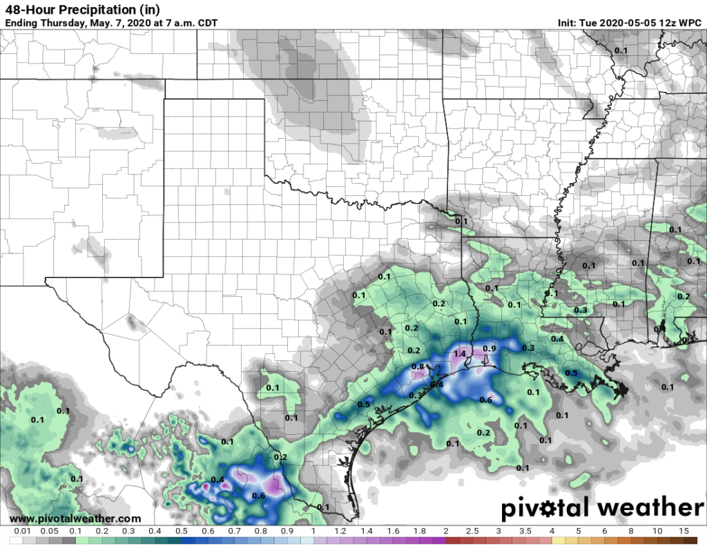
After Houston hit 91 degrees on Monday, the region will see another warm and humid day with highs in the upper-80s. However, a few more clouds today should help moderate highs just a bit. A front will approach, and move through Houston later today and tonight. I’d like to say we have confidence in rainfall amounts, but we don’t. Chances are probably a little better south of Interstate 10—about 50 percent—than further inland. Models are hinting at a band of rain showers that produces 1 inch or more of rainfall, with possibly some hail and damaging winds, but this activity probably will not be too widespread. The best chance of storms likely will occur between the evening hours Tuesday and sunrise on Wednesday.

Wednesday
After sunrise, skies should begin to clear on Wednesday, and we should see a mostly sunny afternoon with highs in the mid-80s. Wednesday evening looks spectacular, with drier air filtering in. Lows Wednesday night will probably drop to around 60 north of Houston, with warmer weather along the coast.
Thursday
Another pleasant, sunny day, with highs in the 80s. As winds turn to come from the south, moisture levels will pick up. The effect of this will be increasing clouds Thursday night with muggier air, and lows in the low 70s.
Friday
The weather again turns more dynamic on Friday as a fairly broad—and for May, strong—cold front approaches the region. The day should be mostly cloudy, with highs in the 80s, as the front nears Houston later during the day. Timing is still not quite nailed down for the front’s passage, but it seems likely that the region will see a decent chance of showers and thunderstorms from Friday afternoon through Saturday morning. Most parts of the region should pick up 0.5 to 1.0 inch of rainfall, but I’m not overly confident in rainfall totals yet.
Saturday
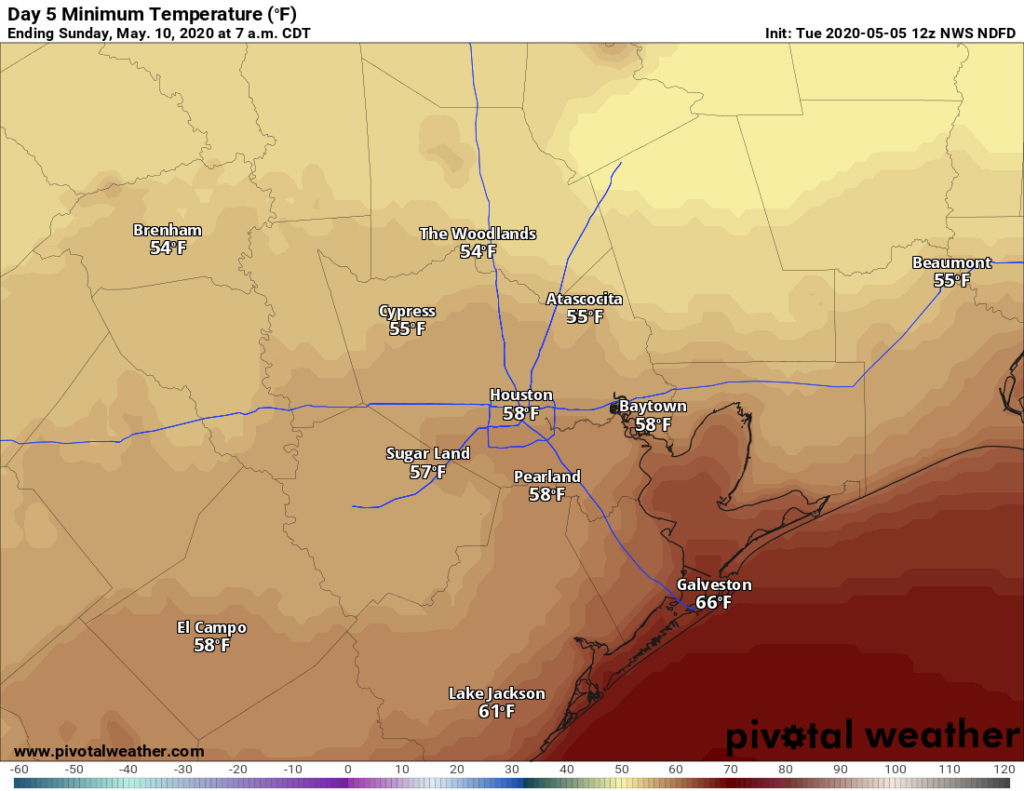
Drier and cooler air begins to work its way into Houston on Saturday, but some clouds may well remain. Depending on the extent of clouds on Saturday, highs may only reach the low 70s. (If clouds exit sooner, we’ll be warmer). Low temperatures Saturday night will probably drop into the 50s for most areas as skies begin to clear.

Sunday
Sunshine should definitely return in force for its namesake day, with dry air and highs of around 80 degrees. This looks like an absolutely spectacular day—the likes of which we’re very unlikely to repeat until late September at the earliest. So get out there and enjoy it.

Looking good for this it seems. https://wingsoverhouston.com/may2020-houston-flyovers/
We have lived in the region since 1984. It is our observation that overall rainfall has decreased from 1″ in an event to .1″. Now that is just our impression, of course. We rarely saw misty drizzle, light rain. It was more a heavy pounding rain. A quick inch then gone. Can you please explain why that might be? A heavy quick rain vs drizzly light? Thank you!!
Anthropogenic climate change is very real. One of the effects is wild variations in normal patterns. You’re seeing it.
Is Interstate 10 used as a landmark to describe where there may be differences in temperature and rainfall amounts, or does it actually influence the weather because of change in terrain and heat generated from its surface?
It doesn’t impact weather itself. It’s jut a convenient landmark to describe how impacts will differ from the north and south sides of the metro area.
Curious…do you have data since 1984 to back up your assertion? I would be interested in looking it over for trends.
It has been a relatively mild spring so far, with lower humidity levels and cooler temps, particularly at night. What effect is that having overall on pollen counts? My allergies have been constant for at least a month (at least, I hope they’re allergies!).
It’s still pretty bad. My sinuses are in agreement.
Any chance the weather on Friday will impact the Blue Angels flyover?
Blue Angels flyover is Wednesday.
I don’t use Facebook but would like to see your video. Any chance you can use Youtube live or Twitch.tv?
Would you talk about capping inversion (on Weather Wednesday) and the affect that it has when there are fronts approaching the area.
For those of us allergic to Facebook, have you considered posting your videos on a new YouTube channel?
Thanks for the suggestion! I’ll upload them to my (for lack of a better option) YouTube channel.
https://www.youtube.com/user/SciGuyVideos/featured
Here’s a link to last week’s video: https://www.youtube.com/watch?v=TSwLttGd2Ws
Ditto on the YouTube request – I don’t do social media either (except to post here).
Done! https://www.youtube.com/watch?v=TSwLttGd2Ws
I wasn’t able to see the meteor shower last night. There were a bit of clouds (not full cloud cover, though) and quite a bit of light pollution.
Question for Weather Wednesday: Is the cap in the atmosphere we experience at times over Houston caused by the heat sink effect of the city? If not, then what? Thank you!
Scattered shower, thunderstorm possible?? Sienna Plantation (at least Steep Bank East where I live) got about an inch in under 1 hour around 7:00-7:30 pm. Was pretty exciting when the front actually went over top of our house.
The WU PWS that is just barely to north of me reported 1.01″ accumulation. and the rate as 3″/hr. The to the south of me in Sienna Point had 1.28″. The one further north and slightly west only got .04″.