In brief: While tropical rainfall is still bound for the greater Houston area later on Tuesday and Wednesday, we now believe the worst of it will remain south of the city. Accordingly, we have lowered our flood alert to Stage 1 for the metro area, which is consistent with street flooding.
As a tropical system in the southern Gulf of Mexico has gotten slightly better organized during the last day or so, we’ve been able to observe its rain bands in real time. This has given us confidence in our forecast for heavy rainfall potential in Houston, and changes in model trends during that time. The bottom line is that we now believe the threat of widespread, tropical rains in Houston has lessened. For this reason we are lowering our flooding alert to Stage 1, which remains in effect through Wednesday.
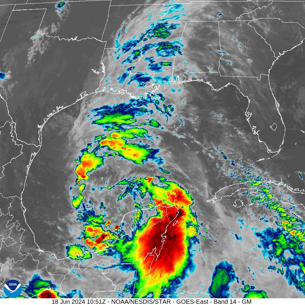
We are now confident that the worst of the system’s rains will go south of the Houston area, perhaps near Matagorda Bay and likely in the Corpus Christi area over the next couple of days. (We’ll be continuing to provide information about this threat to Texas on our companion site, The Eyewall). That’s not to say the Houston area will not see rain, it’s just that we no longer expect the potential for 6 to 10 inches across widespread areas. Rather, while there may be some isolated, significant flooding, for the most part things look manageable.
In terms of timing, this morning looks fairly calm, and I expect the radar to remain mostly quiet through around noon. However, from Tuesday afternoon through Wednesday afternoon, I do expect storm like conditions to develop. Here’s what we can expect in the Houston region in terms of rain, winds, and seas.
Rainfall
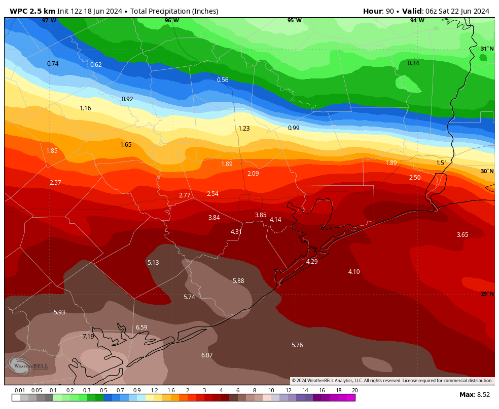
For areas along and north of Interstate 10, accumulations of 1 to 3 inches are likely, with higher isolated totals. For locations further south, accumulations of 3 to 6 inches are likely, with higher bullseyes. The areas of greatest concern are southern Brazoria County and points further south, closer to Matagorda Bay. Overall, the risk remains the threat of high rainfall rates due to the nature of tropical moisture. Again, just to underscore this, I don’t think we’ll see widespread flooding in Houston over the next day or two. However, you should be prepared for some disruptions on roadways.
Winds
Starting later this morning winds will increase from the east to about 20 mph, and gusting up to 30 mph. These winds will be even stronger along the coast, and south of Houston, where some gusts may reach up to 40 mph. These strong winds will likely persist through much of Thursday.
Coastal flooding
We may see tides a couple of feet higher due to the storm, especially on Wednesday. This will lead to the flooding of some low lying areas along the coast and Galveston Bay. In addition there will be strong rip currents in the Gulf. Seas will be rough.
With mostly cloudy skies, high temperatures on Tuesday and Wednesday should remain in the 80s for most of the Houston area. Unfortunately, for many, it looks to be a soggy Juneteenth holiday.
Thursday and Friday
Our atmosphere will remain somewhat unsettled toward the end of the week, and each day will have a decent chance of showers. But the threat of consistently heavy rain should be over by Thursday. Skies will be partly sunny on both days, with highs of around 90 degrees.
Saturday and Sunday
Rain chances won’t entirely go away this weekend, but they’ll be lower each day, likely on the order of 20 percent or so. We’ll also see mostly sunny skies, pushing highs into the low 90s at least.
Next week
Overall, next week should looks fairly typical for late June. I think we’ll see highs in the low- to mid-90s, with at least some low-end potential for rain each day. I’m not expecting anything too organized, but sea breeze showers may definitely be a thing. We’ll see.
Our next update will come later this afternoon.

Just what the Dr. ordered. A few inches of rain and a couple of cooler days due to the cloud cover for the Houston area and a much needed soaking for South Texas. Perfect as we head into the hot season…
I echo this – cloud cover to lop off a few degrees and send the bulk of the rain to the parched South Texas.
For those mewing about this being a “bust”, think of it as a drill. See how your plans need to be tweaked now in time for the real one.
Meanwhile, you have a full pantry, all of your meds (take them, please), and a full gas tank.
Exactly
? Why does the NHC say that another area of low pressure is going to form this weekend? The models were hinting at another system and is this something to worry about?
Bc there’s a system behind it. NHC chart is confusing as it has two systems/areas of disturbance imposed upon each other in the same place.
There is something projected for next week.
NHC says there’s less than a 20% chance over the next 7 days of that system forming a tropical storm. Here’s what they wrote at 7AM this morning:
Southwestern Gulf of Mexico:
Another broad area of low pressure is forecast to develop over the southwestern Gulf of Mexico this weekend. Environmental conditions are expected to be conducive for gradual development of this system early next week while it moves slowly northward or northwestward.
* Formation chance through 48 hours…low…near 0 percent.
* Formation chance through 7 days…low…20 percent.
It’s hard to forecast that far out. Heck, they seem to have worried lots of people in Houston with overaggressive rainfall totals for this week. This is the problem with Space City Weather’s “Stages” of flood alerts. Probably better to just call for a flood “watch” a few days before possible heavy rain, like the NWS does, due to the imperfections of weather forecasting.
That’s why it’s called a ‘projection’. The NHC does this when there is enough data to support the projection. They wouldn’t put it up there if they didn’t find it credible. Physics.
SCW has stages of flood alerts because Houston is built on a flood plain and that’s why it has bayous. They put out incremental alerts because the city floods in increments. The streets are primary, secondary and tertiary. We have reservoirs. When it floods, it can happen in the blink of an eye.
Houston is called the Bayou City for a reason. They didn’t build them for fun.
Thank you for explaining it to “tanstaafl”, hopefully they will understand now.
Thanks for the awesome work you guys do! These updates have been excellent.
I’ll just copy n paste my reply from the last prediction Post …
Nothing at all in Magnolia… much less anywhere else. The “rain” is south of the west coast of Louisiana.
And dwindling.
Or maybe this radar is just a carbon copy from last night? Guess I can go to HEB later this morning and not worry about any rain.
Magnolia is parched . My grass is crispy as I put off watering😫
The forecast has repeatedly been that most rains would not begin until later Tuesday and that parts farther north like Magnolia would likely see only 1-2 inches from Tuesday night through Thursday. You should not be surprised.
You might want to go look at the map from just yesterday which suggested over 3 inches of rain for Magnolia. You can also go one day prior and look at suggestions of 4 inches for that area. Now the forecast has them down to 1.5 inches.
And maybe not even 1.5 inches, @MHa … I’m looking at the Wunderground “future” radar … not much on the horizon … and also the “Microsoft Start” Precipitation map – it’s future thru 2pm shows mild rain to show up at Galveston. Yea, I know, those maps are using Artificial Intelligence, but it’s a hint at the immediate future. I’ve learned to never stress on the weather beyond 12 hours 🙂
.
I’ve lived in the Houston area for almost 67 years … don’t trust ANY prediction one or more days into the future. Okay, gotta watch the end of “What’s Up, Doc”
I stand corrected on the amounts. My apologies.
Should I go to my sister’s baptism in Kemah on Wednesday?
Time has taught me not to rely on any weather forecast, from any source. Not even from smart guys like space city weather.
Yep..this was overblown by all the weather forecasters. Just gonna prepare with food and water and hope my house and car don’t flood from now on. (Asked a neighbor to park my car in their higher driveway.) Likely won’t evacuate for a hurricane either.
Its your choice what to believe and how to prepare for weather events, but its best to stay informed. Weather forecasting is not always 100% , models will change based on the data it receives
People will get mad regardless of the outcome.
I agree with what you are saying but sounding the alarm over the weekend for a storm that has yet to form was a little premature.
naw not an alarmed, just informing folks as to what may happen!
Sounding the alarm was common sense and the only responsible thing SCW could have done. We’re getting off easy this time.
Things devolve very quickly (both people and the weather) when it goes the other way, which it could have done. Be grateful to SCW. They seem like the only place that cares about us and what’s really going on.
And those NHC charts are wind-focused, not rain-focused. Misleading. They’re not telling the whole story, like SCW is trying to tell us.
There are consequences to overly aggressive “flood alerts.” Events were canceled for TODAY when it’s barely spitting outside, if that. A flood ALERT should be for flooding that WILL definitely occur. Otherwise, we should have a flood WATCH like the National Weather Service.
This episode is like a very small version of the blown Rita forecast, which caused thousands to jam the highways for no reason, resulting in 90 evacuation-related deaths.
By the way, Viv. Go to the NHC site for “Potential Tropical Cyclone 1” and you will see a very nice rainfall forecast chart.
hand clapssssssssssss!!
Lol, a flood watch and an alert are the same thing. Tansta gets mad fast.
And make sure sure your flood insurance is up to date.
What are the chances for heavy rainfall in hill country? Still need a good bit of rain up here to fill the lakes.
Can we just go back to the 90 days of hot weather? I’m already tired of hearing about storms after this system.
Do you remember the constant water line breaks, cracking soils, foundation damage, road damage, and crazy high water and electricity bills for the “90 days of dry” with temps of up to 115? I certainly do, so no thank you.
Exactly, people are wild. I’ll take this over last year any day!
Don’t you need some actual precipitation to call for a flood alert? Going from 8+ inches in Galveston to maybe 1.5 (yet to materialize) is a pretty huge whiff in only 24 hours.
Right now I’m anxiously waiting for my husband to leave town on a Boys trip to Port O this weekend. Please tell me the Gulf fishing won’t be blown.
Another system is forecast to form in the SW Gulf this weekend. I am not sure it would be wise to go on a fishing trip offshore or even in the bays for that matter.
We had 0.04″ yesterday at my house near Champions. Today through Wed, National Weather Service forecasts 1.86″ of rain, which is 1.13″ less than they were forecasting yesterday for this time period.
I’ve noticed these comments getting more and more whiny and ungrateful.
Thank you for updating your predictions while every other news source is still like “omgwtfbbq storms coming!!!”
Well said August, I miss the old SCW days when people were just grateful for no hype info predicted as closely as possible. It’s weather.. hard to predict it can fluctuate. It’s summer, it will be hot and miserable in Houston. Matt and Eric are human and doing the best they can. Let’s not take our aggression out on these guys.
If you offer a kid a free ice cream and whenever he comes to take it you pull it away, and you do that enough times and eventually the kid is going to say to you: “$#%^&*%$.”
So what you’re saying is, ppl complaining here have the emotional maturity of a child. That tracks.
It’s exhausting to constantly be on high alert.
I had to put the sprinklers on to my new sod yesterday, and frankly I have even less confidence now that we will see any measurable quantity of rain from this system.
I’ll fire up my in-ground sprinkler system at around 8pm tonight
Given the forecast, should I not cancel our family get together in Sugar Land Thursday afternoon? We were going to erect a bounce house in the spacious backyard (my brother, who is 4 inches shorter than me, has acute claustrophobia). Since there is no significant wind threat I’m assuming this is still feasible. Also we put down a non refundable deposit for Red Lobster catering (who haven’t canceled), but as a precaution we wanted to throw some Nolan Ryan hot dogs on the grill in case any of the extended family has shellfish allergies. Are we good to go for outdoor grilling too?
To quote a line from Field of Dreams….”look for low and away…but watch out for in your ear!” I think this fits this forecast.
Yep. 0.2 inch Monday and another 0.2 inch today in Clear Lake.
Y’all are the best. Thank you for the updates and real look at the risks as more information comes in.
I have a flight out of IAH tomorrow AM, I’m thinking it is 50/50 that it gets out on time or at all 🙂
OMG……….how did people survive when they didn’t know how much rain they were going to get and what day it would rain. I feel like some of you expect an hourly forecast 48 hrs out that is very precise. If you are going to be a WeatherNerd, then you have to assess the forecast of multiple sites to get an overall idea of possible weather conditions and then you might get “somewhat” of an idea for the next 48 hrs. SCW-AccuWeather-NOAA-Wunderground-Weather.com. It takes time and some common sense. I make my living outdoors, so I follow the weather closely. Matt and Eric, you’ll never make them all happy. I feel for you guys 😳
Weather forecasting should get better with time. Not worse. Right now it’s the latter and exponentially so. It’s not about common sense – it’s 100% about science. Don’t be obtuse.
isn’t the whole point of weather forecasters to summarize what will happen based on all these websites, models and their expertise? Some people just want a summary of what will likely happen. They don’t want to visit 5 websites and look at all the information or they don’t have the knowledge about weather systems or they may not have the time. Weather forecasters get paid to summarize these models and websites for the layperson. Why even have weather forecasters if we’re supposed to do the work ourselves?
I can spend a whole five minutes viewing 2-3 weather sites and figure out what’s gonna happen soon (for this “layperson” , anyway )
.
Sadly, weather forecasting is just that – a guessing game 🙂
all this scandal for nothing lol
Lol!!!
Rain bands causing 6-8” of rain in Houston metro and a stage 2 flood alert from a tiny, unnamed storm hitting Central Mexico never really seemed plausible. My husband and I said “watch, we won’t get a drop out of this” and we may just be right. Unfortunately, all it does is cause inertia the next time this happens (which it will). The rhetoric used here may not be inflammatory but could the forecasts still be hype? Perhaps. Or maybe the rain really will come tomorrow.
Time to turn the sprinkler system back on!
Anybody receive any rain today yet? None here in the Galleria area.
yes, west/memorial area
You complainers and whiners should truly be grateful you have the time in your life to get on this website and complain about forecasts. I hope you don’t pass on to your sons your sissiness (not the word I want to type, but out of respect to the women on this site, I don’t).
Sexist. There’s nothing wrong with a man not being a tobacco chewing, woman grabbing, crotch adjusting guy. And not everyone complaining on this website is a man.
Yawn
Hubby and I are loving the weather we are getting in Baytown today along Cedar Bayou. Cooling breezes and soaking rain. We’re remembering how both of us flooded out our cars driving in the surprise June 1973 flooding rains when they didn’t tell us squat. I’d rather be alerted and then grateful when it’s not that bad…because it could definitely be worse!
Does Houston needs to Evacuate?
Do y’all remember the evacuation of Hurricane Rita in 2005??
What a nightmare!!!!
It was awful I will never evacuate again!
It did appear that the hoard stuck on I10 were like a bunch of lemmings.