Good morning. Sorry for the late update this morning, but sometimes life intervenes. Fortunately, the forecast remains more or less on track. The region will enter a wetter period now through Sunday, with some heavy rainfall possible on Christmas Eve ahead of a cold front. After the front moves through we should see clear and much cooler weather for Christmas Day and the holiday weekend leading up to New Year’s Eve.
One quick programming note: Given the dynamic weather possible on Sunday, expect at least one update this weekend to make sure you’re on top of the forecast.
Friday
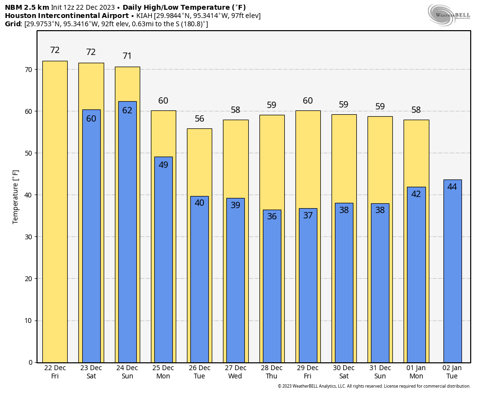
Today should be fine for any last-minute shopping or other activities related to the holiday weekend. Yes, we could see some (mostly) light showers, but I don’t think they’ll be anything more than a nuisance. Skies will, otherwise, be gray with high temperatures reaching about 70 degrees or a tick higher. Winds will be light, from the east. Lows tonight will only drop into the low 60s, for the most part. As we saw some fog this morning, you can probably expect more of the same on Saturday morning.
Saturday
Saturday will be similar to Friday with one exception: Rain showers will be a little more widespread, with a better chance at some moderate rainfall. I still don’t expect anything too heavy, as that’s more likely to occur on Christmas Eve. Otherwise it will be another soupy day, with highs in the vicinity of 70 degrees, and a not very cool night in the low 60s.
Sunday
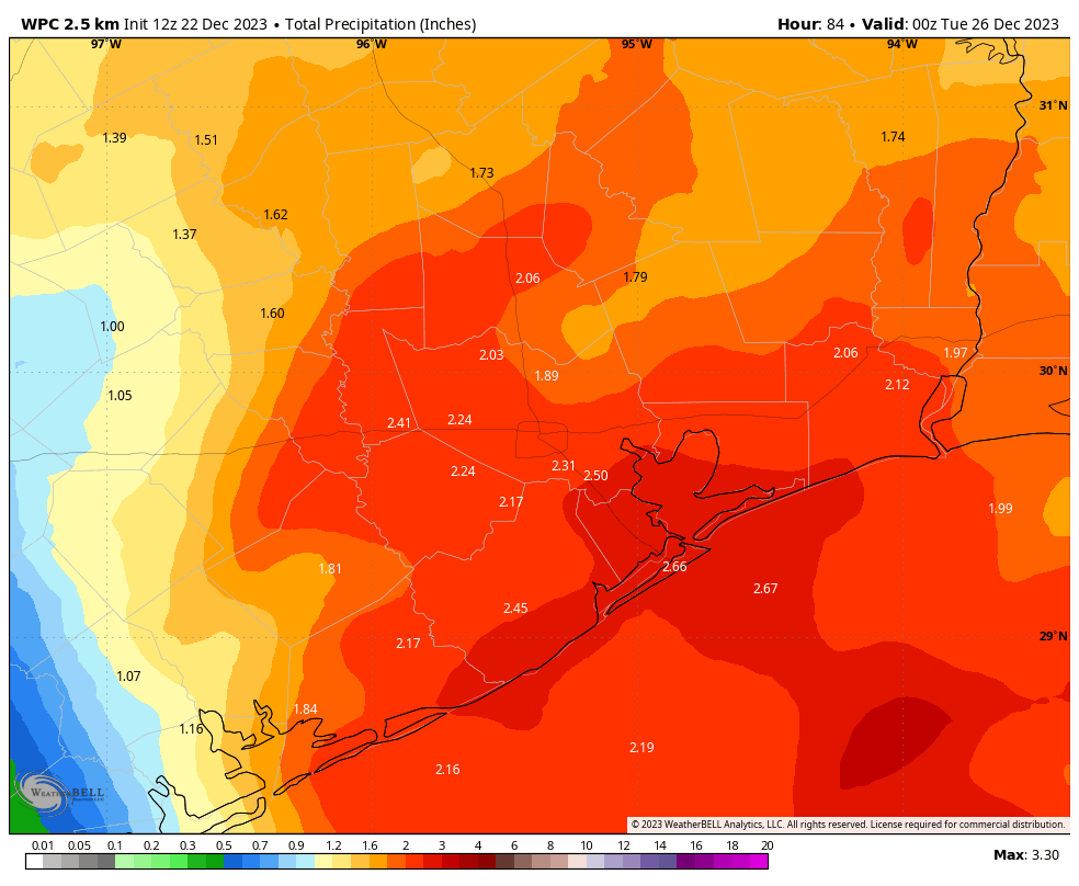
You’ll probably have noticed that it feels more humid outside this morning. Well, after a couple of days of an easterly breeze we’re going to see a lot of moisture in the atmosphere, and that’s a starter dough for rainfall. By Sunday we’ll add in a forcing function in the form of an advancing front. In terms of timing, I expect most of the rain to occur during the midday or early afternoon hours, as a line of storms advances from west to east across the region. Most of us should pick up 1 to 2 inches of rain, but there could be higher isolated totals that lead to some brief street flooding. Right now the overall dynamics in the atmosphere don’t favor severe weather, but I’m keeping tabs on that. Hopefully this mess will clear out by the late afternoon or evening. Lows on Sunday night will drop to around 50 degrees.
Christmas Day
The holiday should be bright and sunny, with highs of perhaps 60 degrees. Winds will be a bit gusty, from the north, perhaps at 20 to 25 mph. So that will add a bit of chill to the air. Lows on Monday night drop into the low 40s for most.
Next week
We’re looking at fairly typical winter weather, with mostly sunny skies, highs perhaps in the low 60s, and nights generally in the 30s and 40s. It will be a good time to wear those sweaters you got for Christmas. As for New Year’s Eve, it’s very early. I can’t rule out some rain showers, but there’s no particularly strong signal for that. It does look chilly, however.


Thank you so much for your dedication to “our” weather reports! Merry Christmas to you both and your families!
We need rain, hope we get a couple of inches. Merry Christmas to all!
Do people really gift sweaters here?
They are considered heavy winter gear.
Well, hopefully the rain moves through in time for services Sunday night. And things dry out for back yard football after dinner Monday.
Thanks to the entire crew that make Space City Weather possible. You all are a treasured weather resource for us followers.
Merry Christmas to all!
I’m glad we’re getting a good front in here just in time for Christmas. I just wish we could witness the temp dropping during the day without having to stay up all night.
Thanks. Merry Christmas