In brief: The forecast for our winter storm is coming into clearer focus this afternoon, and we now anticipate fairly widespread ice impacts on Sunday, which may extend into Monday. There is also the potential for thunderstorms (and thundersleet!) before the precipitation ends on Sunday. It’s all happening in winter storm 2026 Houston.
What to expect, and when
For this afternoon’s post we are going to break things down into what people should expect, and when. Houston will face a mix of winter-inspired threats over the next two days, everything from thundersleet—yes, it’s a real thing—to ice on roads. The bottom line is that we all need to have a little patience over the next 24 to 48 hours until Mother Nature sorts its issues out.
Tonight
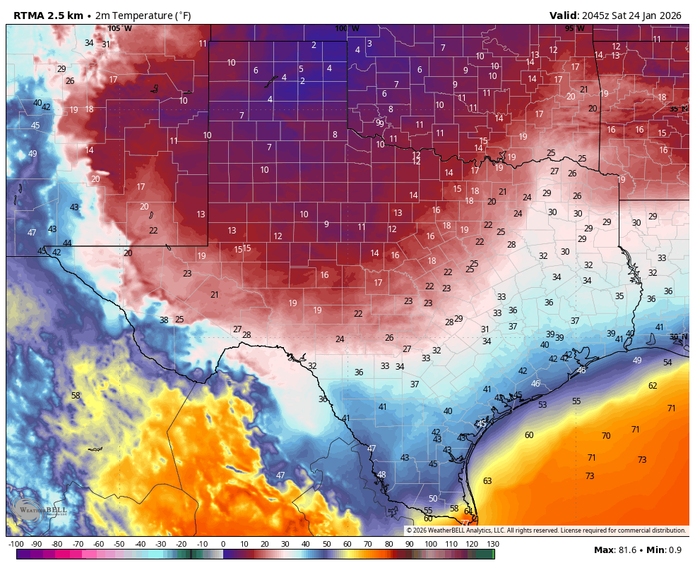
We’re already seeing temperatures falling into the upper 30s north of Houston, and this downward trend will continue. Freezing temperatures will arrive in places like Katy and The Woodlands around midnight tonight, and should move into much of the rest of the metro area (barring the coast) by sunrise on Sunday. During these overnight hours cold rain will transition to freezing rain and, in some cases, sleet. There is also the potential for some thunderstorms, in which case we might get a rare thundersleet sighting, in which sleet falls during a thunderstorm. In locations where sleet falls (which is preferable to freezing rain) there will be less ice buildup on streets. In any case, when you wake up Sunday morning we’re going to see a different world.
My baseline expectation is for 0.1 to 0.25 inch of ice accumulation along and inland of Highway 59/Interstate 69. As for areas south of this, and closer to the coast, we can probably expect a trace of ice perhaps up to 0.1 inch. The bottom line is that roads will potentially be hazardous anywhere but the immediate coast. Our best advice is to plan to stay home on Sunday, and limit any travel to emergencies only. Even if you are the world’s best ice road trucker, chances are your fellow drivers are not. For good real-time information about ice on Houston’s roadways, be sure to check Houston Transtar’s road incident page.
Sunday
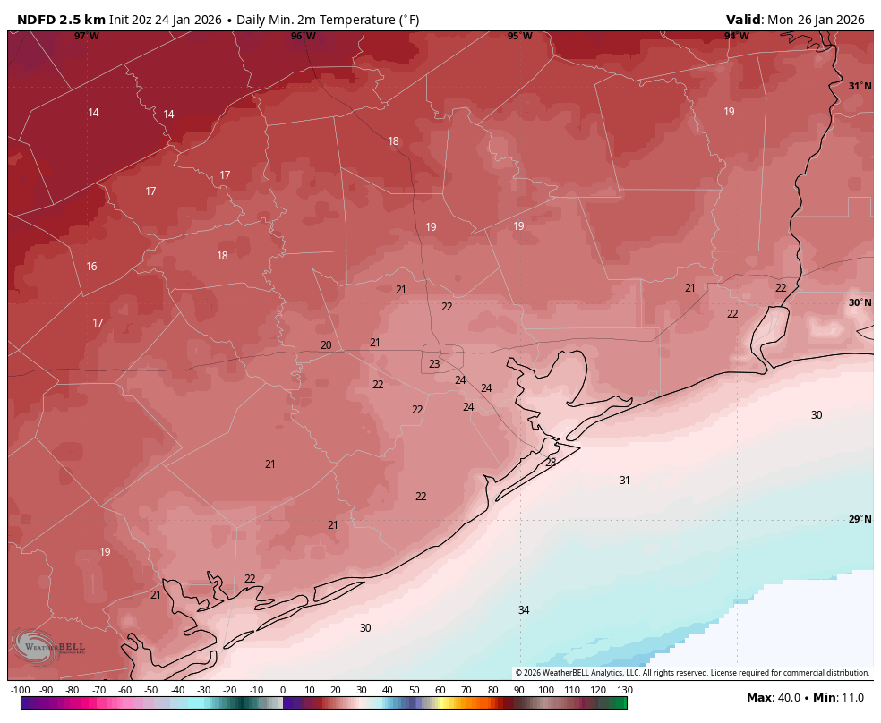
It will be interesting to see how high temperatures get on Sunday. Parts of the area (again, most likely locations along and south of Highway 59) will probably get above freezing for a few hours on Sunday afternoon. This, in concert with gusty northerly winds, and potentially a some patches of sunny skies, may do some work on drying out roads. But then again, maybe not. And for areas further inland I’m just not confident in ice melting at all. I mean, it could happen. But if there’s enough ice, it will take longer than an hour or two of 35 degrees to take care of it. Temperatures will plunge back below freezing by 5 or 6 pm CT on Sunday, and we’ll be in for a cold night. However, the likelihood of clouds on Sunday night may take some of the edge off of low temperatures. I expect lows to remain in the vicinity of 20 to 25 degrees in urban Houston, with areas west (i.e. Katy) and north (The Woodlands) potentially dropping into the upper teens.
Monday
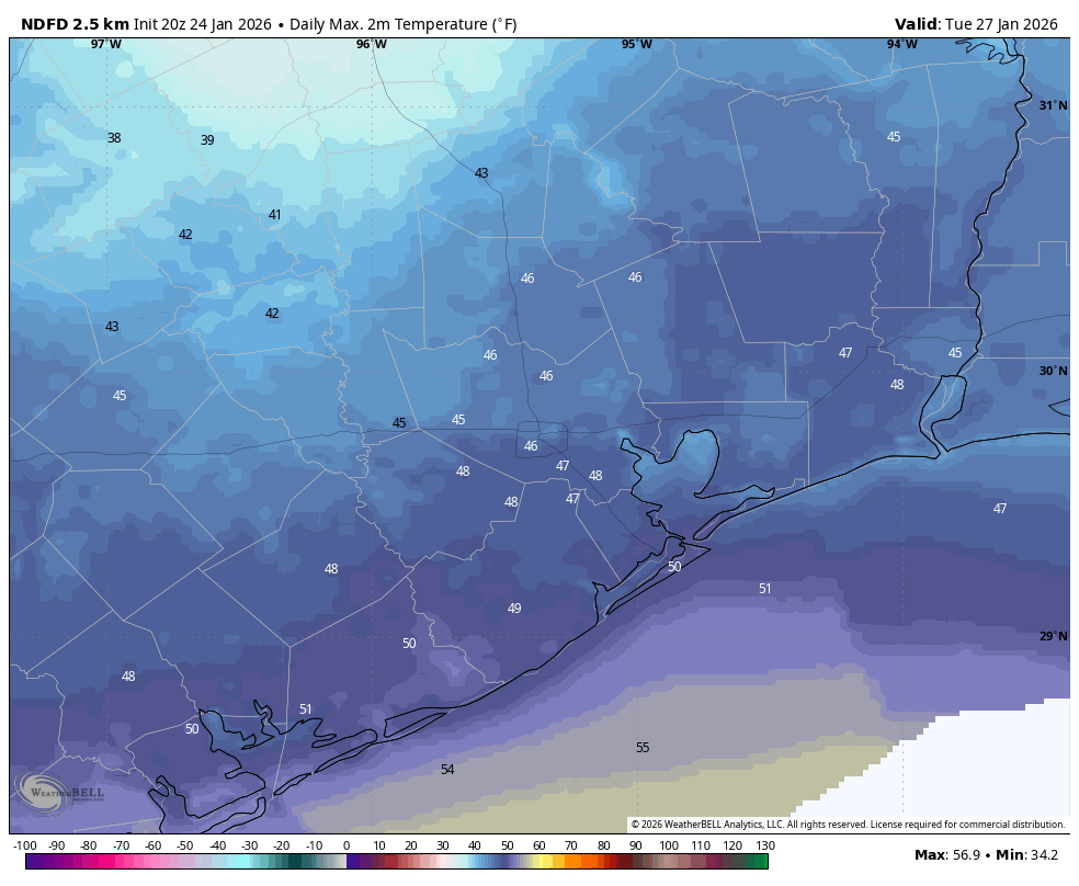
We’ve had the road discussion already, but I think freeways and local streets on Monday will be a mixed bag. Coastal areas probably will be OK. Areas further inland, probably not? I’m just not sure how well, or to what extent, our regional ice treatment services will do. I could see things being passable near downtown Houston and the Texas Medical Center, but I really want to see where we are on Sunday afternoon before making a definitive call. Anyway, we start out very cold on Monday, but with sunny skies I’m hopeful that most of the region gets to highs of 35 to 40 degrees. I think this, in concert with sunshine, should do work on icy roads. But again, I’m not 100 percent confident in that. Anyway, lows on Monday night (with clear skies) could be a degree or two colder than Sunday night.
Tuesday
If you’re wondering when you can stop worrying about this deep freeze, the answer is late Tuesday morning. By then temperatures will be recovering into the 40s.
Eric, what about the next Arctic front?
Yeah, we are probably going to see another cooldown next weekend. I think there’s a decent chance of a light freeze, and although we can’t rule out a hard freeze the signal for extreme cold is not nearly so strong as it was for the current event. There is also a signal for some snow, but we’re not going to make any promises to the kids just yet.
We will have one more update today, likely late this evening, by or before 11 pm to share our latest thinking on the forecast.
