In brief: The forecast for Hurricane Beryl and Houston remains more or less on track, which is to say the storm is still expected to go far enough south that it will not produce serious wind and surge impacts in Houston. We continue to watch the possibility of tropical rain next week.
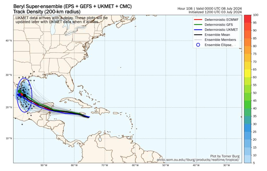
Just a quick update on Wednesday afternoon to point out that our forecast from this morning on Hurricane Beryl, which currently as 140 mph sustained winds and is lashing Jamaica, is more or less on point. In fact, the data we’ve seen today from our most-trusted models continues to provide confidence in a track predicted by the National Hurricane Center. Their outlook brings a strong tropical storm or Category 1 hurricane to the northern Mexico coast, 50 to 100 miles south of Texas, on Sunday evening or Monday morning.
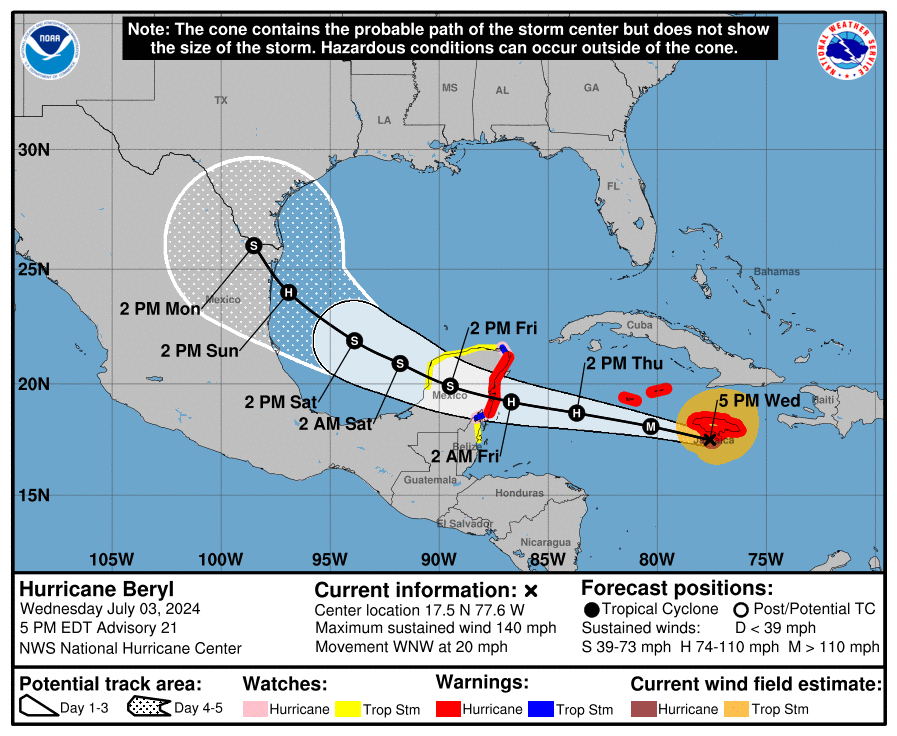
We are still four to five days out in terms of a track forecast, so there are no absolutes here. But the fact that we’ve seen a convergence in modeling today, particularly in a track forecast from both the European and GFS models, gives me further confidence that Beryl, with its winds and seas, will likely not be much of a factor in Houston’s weather next week.
There is still the potential for heavy rainfall, particularly during the Monday through Wednesday timeframe. My sense is that the most likely scenario is that much of our region will pick up 2 to 4 inches of rainfall, with higher bullseyes. But I do not have as much confidence in the precipitation forecast, and certainly we cannot preclude the possibility of intense tropical rainfall and flooding in the Houston metro area. For now, however, we have no plans of issuing an alert on our flood scale. We’ll continue to monitor things, of course.
The bottom line is that Beryl is probably going south, and making a final landfall in northern Mexico. There will be some impacts for South Texas, including the possibility of inland flooding. As ever with tropical weather, forecasts can change. We’re just getting closer to the point where we can definitely say they won’t in regard to Beryl and Houston.
I’ll have a full update on Houston’s weather for you tomorrow morning, on the Fourth of July.

What do you think about Beryl once on land turning north and following the coast line as annoying rain/thunderstorms or even MAYBE a tropical depression?
I mean, if you want to worry about a scenario that has maybe a 1 percent chance of happening, feel free. But I wouldn’t.
Great thank you. And it is my job to worry and think about anything and everything that could happen and be prepared.
I don’t think there will be too much discernible difference for us between an unorganized tropical wave and an official tropical depression. The main thing to watch out for will be to see how long the system does linger over us in the case it stalls. From what I’ve seen, the possibility of it stalling is there, but nothing like Harvey levels.
Thank you Andy! I want to make sure I cover all possibilities and that we are prepared.
Appreciate your updates ✔️
Thanks!
Can’t leave this up to chance. EVACUATE KATY NOW
As always I trust your information more than any
Other,
Thank you for the update
Here’s to hoping it continues westward and provides much needed rain to west texas and the big bend area – they are currently under EXTREME drought according to the latest US drought monitor update, while our side of the state has no drought at all.
We may not have drought at the moment, but with no precip in past week and no guarantee for rain after this storm, I’ll take what we can get. My lawn isn’t quite as lush as it was a couple weeks ago and sure could use an inch or two of rain!
What’s the educated guess one Beryl makes landfall? I’m in western Mexico but storms that go well inland often juice up our atmosphere (last one sure did).
The very first paragraph of the article answers your question.
“Their outlook brings a strong tropical storm or Category 1 hurricane to the northern Mexico coast, 50 to 100 miles south of Texas, on Sunday evening or Monday morning.”
There’s even a nice picture under it.
Tuning into the Kingston, Jamaica TV station, doesn’t look like much impact to Kingston on the SE coast (40-50 miles from center of eye), but other smaller cities on southwest coast may suffer. Storm is moving fast.
What does Galveston Island look like for rain on Monday?
Supposed to be heading to South Padre on Saturday. Should we wait until mid week?
According to the Weather Channel, there will be 1.15 l” of rain in the late Sunday afternoon and 2.6” of rain from Monday 12 midnight to 12 noon. There is 50% chance of rain Tuesday. I hope that helps.
I have a friend in Cancun with a scheduled flight departure of 5:22 pm CST tomorrow. She told me today that based on info from local authorities there it was expected to make landfall (in their general area) late tomorrow/Friday morning. Your post mentions Sunday evening/Monday morning…significantly different in timeline. Any thoughts on that? Thank you as always for all you do!
He wrote “Their outlook brings a strong tropical storm or Category 1 hurricane to the northern Mexico coast, 50 to 100 miles south of Texas, on Sunday evening or Monday morning. ”
“Northern Mexico Coast”.
This is the landfall AFTER it passes over the Yucatan Peninsula.
Hurricane Hater, Cancun is on Mexico’s Yucatan peninsula, which has been in the forecast path of the storm for the past week. If the northern Mexico coast track pans out that means Mexico will experience two landfall events from the same system.
Yes, that’s what I said.
When I look at the radar, I can barely see Beryl as she hits the islands.
I noticed that, too, and wondered why.
We have a vacation planned in South Padre next week. What are your recommendations?
There will be 2.6” of rain forecasted from 12 midnight to 12 noon on Monday. There are chances of rain 45% to 65% from Sunday to Thurday. There is no forecast after Thursday on the Weather Channel App. I hope that helps.
Should Katy evacuate
The wind shear is one factor that enters into the equation for Beryl, compared to, say, Harvey … so let’s assume Beryl will drift off into Mexico as predicted
I’m supposed to travel to Cancun on Friday. How badly do you think Beryl will impact that city?
Thanks for the dedication and effort bringing us the most accurate and expedient information
Thank you for all you do and giving us the most informative and “real” weather updates. You’ve helped me and my nerves get thru many storms in my life and I’m so grateful. Please ..please don’t ever change