In brief: Francine has rapidly developed on Monday and is nearing hurricane strength. In terms of a track forecast, it still appears as though the tropical system will remain far enough off the Texas coast to spare the Houston region of significant impacts. We’ll continue to watch things closely, however.
Francine status
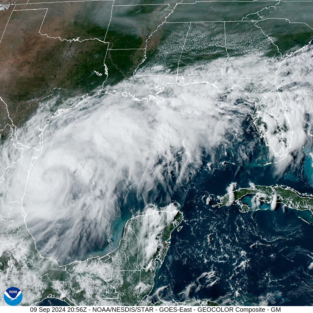
As of 4 pm CT, Tropical Storm Francine is nearing hurricane strength, with 65-mph sustained winds, according to the National Hurricane Center. The storm’s central pressure is dropping, and further intensification is likely. Francine is moving to the north-northwest at 7 mph, and is about 150 miles to the south-southeast of the mouth of the Rio Grande River. Francine has developed an eye this afternoon, which can be seen in satellite images and on the Brownsville radar.
Francine track and intensity
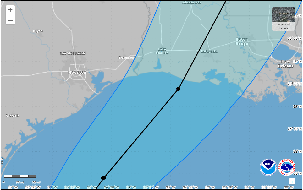
The general forecast for Francine has not changed. The storm is expected to continue moving mostly to the north today and tonight, before making a turn to the northeast on Tuesday. This will essentially allow the storm to track along the contour of the Texas coast, but remain far enough offshore to preclude significant and consequential impacts in terms of rains, winds, and storm surge for most of the upper Texas coast.
By Wednesday evening or night, Francine is expected to reach the southern Louisiana coast, perhaps near Vermillion Bay. It is likely to be a hurricane at landfall on Wednesday afternoon or evening when it comes ashore in southern Louisiana.
Houston impacts
Based upon the latest high resolution modeling, we could start to see some rain bands from Francine moving into Galveston Island and other coastal regions by around mid-morning on Tuesday. My sense is that the vast majority of the region along and inland of Highway 59/Interstate 69 is not going to see much precipitation from this storm, probably 1 inch or considerably less.
Coastal areas have the potential for more, but at this time I would consider the accumulation forecast shown below as a reasonable worst-case scenario. We do not anticipate significant street flooding at this time. Rain is most likely from Tuesday morning through Wednesday morning, after which chances should rapidly diminish.
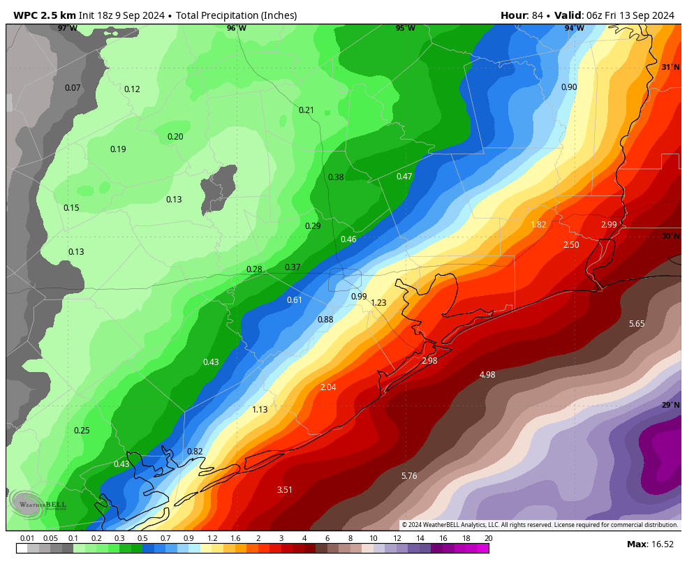
In terms of winds, I expect gusty winds on Tuesday, but nothing wild. Most of the area, including the coast, probably will see some gusts of 20 mph or above. Winds will pick up Tuesday evening and during the overnight hours, but I think the upper limit is sustained winds of about 40 mph right along the coast, with gusts of perhaps 50 mph. (Winds will be noticeably less inland). These kinds of winds should not be enough to provoke significant issues, although some isolated power issues along the coast cannot be ruled out.
Seas will rise 1 to 3 feet above normal at high tide, so only very low-lying areas should see issues on Tuesday night and Wednesday.
All in all, we continue to believe that Francine will be a manageable storm for most of Houston.
We’ll continue to monitor the situation closely, and if anything changes we’ll have an update later tonight—given the angst and interest out there, we might update this evening regardless. If not, we’ll see you first thing on Tuesday morning.

Thoughts about a comparable storm to this one? Asking from the island.
Alberto-lite would be my comp at this point.
Genuinely curious, what is going to cause it to hook to the east, since it’s generally following a north northwest path right now. In Houston, and still have PTSD from Beryl, so just curious. Although this was reassuring to read. And thank you for the no dramatics or hype!
There is a high pressure system over Florida and Cuba that Francine will move towards.
It wants to move to the northeast as it gains latitude, and it’s basically going to follow the contour of a high pressure system to its east. The track forecast with this one does not seem overly complicated to me.
Thank you!!!
According to the National Hurricane Center, there is also a trough over Texas that is approaching the system and the stronger flow between the trough and the high to the east will help turn Francine to the northeast and also increase its speed.
Will there be an SCW flood alert for downtown Houston for Francine?
They said most of the region would receive one inch of rain or less and that significant street flooding is not expected, so my guess is no.
If it stays on this current track, Houston will be on the left or West side of the storm, which is known as the clean side…The east or ride side of the storm is typically know as the more “dirty” side and that is where you see a lot of flash flooding, high winds and tornadic activity. SO fingers crossed that his track remains true..but it’s looking good for us here in the H
There will not, unless the forecast radically changes. Which I don’t anticipate.
Quote: “The storm is expected to continue moving mostly to the north today and tonight, before making a turn to the northeast on Tuesday. This will essentially allow the storm to track along the contour of the Texas coast, but remain far enough offshore”
So the question is … “what” is forcing Francine to make a turn and to track along the contour?
Thanks for the afternoon update !
I was wondering this too, and asked above…I’m wondering if it’s the wind shear, and cooler dry air off the Tx Coast that is pushing it off… not a scientist though so no clue – but definitely curious on this one! The science geek in me wants to know!
At lower latitudes hurricanes are pushed to the east by the trade winds. If the hurricane tracks far enough north it gets picked up by the westerlies, thus changing the direction of the storm to the NE. The southern U.S. sits right on this boundary between the trades and the westerlies. See:
https://hurricanescience.org/science/science/hurricanemovement/index.html#:~:text=Once%20a%20hurricane%20reaches%20further,and%20accelerate%20towards%20the%20north%2C
There is a high pressure system over Florida right now. That has a clockwise circulation. Francine will ride the outer edge of that circulation .
There is a shortwave trough over Texas that is moving west and picking up Francine before it joins with it inland. And the high over Florida as mentioned.
Aggie: According to the National Hurricane Center it’s a high pressure system to the east of Francine, and also an approaching trough over Texas. The trough will actually help the high pressure turn Francine to the northeast and also increase its speed.
Thoughts on driving conditions in Beaumont Wednesday and Thursday?
Perfectly fine unless this shift radically west, which I do not expect. On the current track forecast I think there are no issues.
There’re no way this won’t rapidly intensify. Am PTSDed too, after the three May storms that seemed to can-opener our roof and then Beryl that almost finished the job.
Will there be wind impacts to the Woodlands if Francine becomes a 2 or 3?
Hope this eases your mind some – if Francine stays on or close to the current track, Houston will remain on the clean side of the storm. Up in the Woodlands, effects would be extremely minimal….
Francine will almost certainly become a Cat 2 by landfall, and would not be surprised to see Cat 3 (major hurricane) given the recent intensity trends.
That said, TW and the Houston metro should not see much impact regardless of strength as the track will be well to our east. I wish our friends in Louisiana the best… I have a feeling this storm will be stronger than anticipated
It’s good to be cautiously optimistic. We are wrapping up the hottest year on record. Remember, just a few short days ago this was just going to be a weak TS. Now it’s a Cat 2.
This is a dangerous storm and one need to be taken lightly. We’ve been surprised before both for the better and for the worse. Stay tuned.
Thanks for keeping us updated, as always! May be a silly question BUT could use you and your readers’ advice.
We were needing to drive to Florida (from Houston) for a funeral that is scheduled for this Friday AM…we planned to leave Thursday early AM for a 14 hr drive prior to this storm popping up 🙁 With these updated predictions it feels like we can still leave as scheduled? My concerns are mostly damage along I-10 as we drive East. I also think that tornado like activity could also linger, but that is from experience and not at all an academically supported thought. We appreciate any insight and assessments (along with your readers’ thoughts) that you all feel comfortable providing – you all are ones I trust most so I appreciate any reliable weather resources, too. We are OK with not traveling at all as well but I figured I would at least pose the question to experts ☺️
Francine should be long gone by the time you leave. I suppose there is the potential for flooding on I-10, but at this time I think the freeway should be passable. Cannot rule out downed trees or other impediments however.
You are correct. A lot of angst.
I have a funny feeling about this storm. I’m concerned that it has a few surprises up its sleeve.
What are the chances this could end up not turning to the east? I know storms can “wobble” etc and change course. Hurricane Rita comes to mind.
East, as in striking Galveston Island east? I’d say there’s a non-zero chance, but probably on the order of 1 to 3 percent. So really not something to worry about.
Galveston State Park (RVs etc) near Jamaica Beach is closing because of Francine. And “opening on Fri 13th if conditions allow”
That’s likely because of the storm surge risk, and not because they anticipate a head on landfall there.
Eric, the expected landfall was moved up with the 4PM CDT advisory. Landfall is now estimated for just after 1PM Wed (NOT Wed evening or night), somewhere on the Louisiana coast. (The eastern edge of the cone is just west of the Louisiana/Texas border.
Got a girl, her name’s Francine
Finest thing you ever seen
And I love her, she’s all that I want
And I need her, she’s all that I need
Well, Francine, oh Francis, why
Do you love me and make me cry?
How I love her, she’s all that I want
How I need her, she’s all that I need
One New Orleans weatherman at WWLtv just pointed out that the models have shifted substantially to the west while the NHC has only moved the forecasted path slightly to the west. Is this a trend or just a slight correction?
The important models have not really shifted west at all. In fact the 18Z GFS just came in and it is further east than earlier today.
Thank goodness! We need a break
I’m beachfront Galveston; think I’ll get a room at the Moody.
When looking at the photo of the storm I am curious what is up with the enormous amount of clouds? Does this indicate anything in particular? Or is it just what it is in this instance? I have to admit it took my breath away a little when I scrolled down to it.
Most of what you stretched across the northern Gulf is moisture and cloudiness piled up against the old cold front that pushed offshore.
My father-in-law has a home in Sulphur, LA. Can you give any insight as to how Sulphur might be affected. Thank you.
Check out their sister site The Eyewall for more info on where it is likely to hit
I’m supposed to fly into Houston early tomorrow morning and out again Wednesday afternoon — reading this, it sounds like it’s reasonable to get on the plane tomorrow? (Bringing a spare change of clothes just in case.)
Wondering if our flight from NYC to Hobby tomorrow (Tuesday) night will be affected?
Thoughts on Orange, Tx? Supposed to drive over at lunch on Wednesday…