In brief: This is a short post to wrap up our coverage of Tropical Storm Francine, which as expected is having a negligible effect on Texas as it remains well offshore. We also take a look ahead at potential tropical activity over the next 10 days or so.
Francine forecast
As of late this afternoon, Tropical Storm Francine is located due east of the mouth of the Rio Grande River, about 135 miles off the coast. This is about as close as the storm is going to get to Texas as it has assumed a northeastward movement that will take it toward the Louisiana coast. Forecasters at the National Hurricane Center expect the storm to reach the south-central coast of Louisiana by Wednesday afternoon as a Category 1 hurricane.
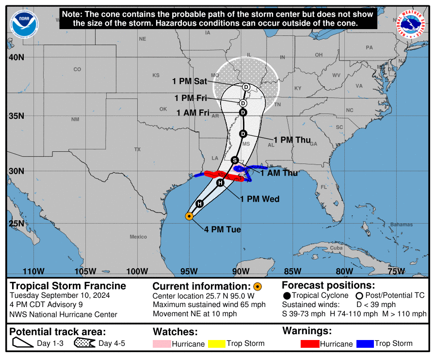
We have been, and will continue to cover the implications of Francine for Louisiana on our sister hurricane website, The Eyewall.
Houston-area impacts
Not much. We’ve seen some sporadic showers today, and that will continue tonight and into Wednesday morning. Inland winds will not be far above normal levels, and even along the coast I don’t expect gusts to exceed 35 or 40 mph, which is not something to be overly concerned about. Tides will run 1 to 3 feet higher than normal tonight and Wednesday morning.
All of this, to the extent that there is anything, will be gone by Wednesday afternoon. The main impact from Francine for Houston is lower temperatures, with highs in the mid-80s today and Wednesday. We’ll be back in the low- to mid-90s soon, so enjoy this.
What’s next in the tropics?
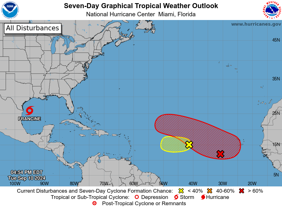
In short, not much we need to worry about. The National Hurricane Center is tracking a couple of areas of low pressure in the Central Atlantic Ocean. However, none of the reliable models bring either of these systems, if they develop at all, toward the Gulf of Mexico. Beyond that, the Gulf of Mexico looks pretty quiet for the next ten days. We’re getting closer to the end of the tropics season for Texas, which is great. But we’re not there yet.

When is the end of the tropics season for Texas?
Traditionally October 1
Unofficially, the date I go by is September 24. Hurricanes can strike Texas after this date, but they’re very rare, about a 1-in-50 years type occurrence. We’ll see what the tropics look like in two weeks before making a call on whether we think the Texas tropics season is over.
Usually around October. Only 3 hurricanes have made landfall on the coast in October.
Thank y’all,for all y’all do
Currently due WEST of the mouth of the Rio Grande? I don’t think so!
…….about 22,000 miles west
Thanks! It’s been a long day.
“As of late this afternoon, Tropical Storm Francine is located due west of the mouth of the Rio Grande River, about 135 miles off the coast.” – due east….
Compared to the 2005 hurricane season which was incredibly active, this one seems pretty mild. Was the forecast for an incredibly active season inaccurate?
It does appear so, yes. Especially with things looking fairly tepid for the next week or two. We’ll definitely have more to say about this in the not too distant future.
The Eyewall made a post about a week ago discussing why this season has been fairly quiet, despite the early predictions. It’s an interesting read.
Glad we didn’t live up to 2005-type activity, but I worry that this year’s forecast bust will cause some folks to not believe predictions for subsequent years
people’s distrust of weather predictions has been going on for years unfortunately.
1st, thank y’all for your tenacious work.
2ndly, lolol 😆 we’ll be back in the 90s soon, so enjoy this.
🌧️🙏🏽☔ seriously thank you and perfect time to sow some greens 🥬 seeds
The latest Gulf hurricane in recent years, to my knowledge, was Hurricane Jerry on Oct. 15, 1989, which hit Galveston.
Is Francine’s eye falling apart? It looks like it on the radar.
Won’t a weaker storm system mean more impact for TX?
Glad that it’s going to hit at a 1 and not a 3 like some predicted.
Writing “Rio Grande River” is like saying the “Dept of Redundancy Dept”. Simply “Rio Grande” will suffice.
Why not call it what our friends south of the border call it….. the Rio Bravo del Norte.
Wouldn’t it be the Rio Grande del Sur to Texans?
Rita, Ike, Beryl and now Francine among many others were all storms that moved further east than forecast. It seems the models have a westward bias to them and storms are much more likely curl off to the east than they are initially forecast.
Look out for the ones forecast to make landfall southwest of us…
The talk in the comments about the 2005 Hurricane Season, as well as the usual “end” of the Hurricane Season annually, reminded me of this classic – https://xkcd.com/1126 (a.k.a. The Saga of Epsilon and Zeta)
Thanks for all y’all do! My thoughts are with our fellow Cajuns.
Seriously thank you for all of your coverage, it makes a difference!