In brief: A cluster of non-severe storms will impact southern parts of the Houston area primarily this morning. A few additional storms could fire, especially east of I-45 or at the coast later today. We’re also keeping tabs on a chance of storms Sunday, followed by standard June fare next week.
Today
Another active radar this morning. It feels like it’s been this way a few times this week! Anyway, there is a complex of non-severe thunderstorms moving into the Sealy and Prairie View areas now. That will head into the rest of the Houston area, especially along and south of I-10 over the next few hours.
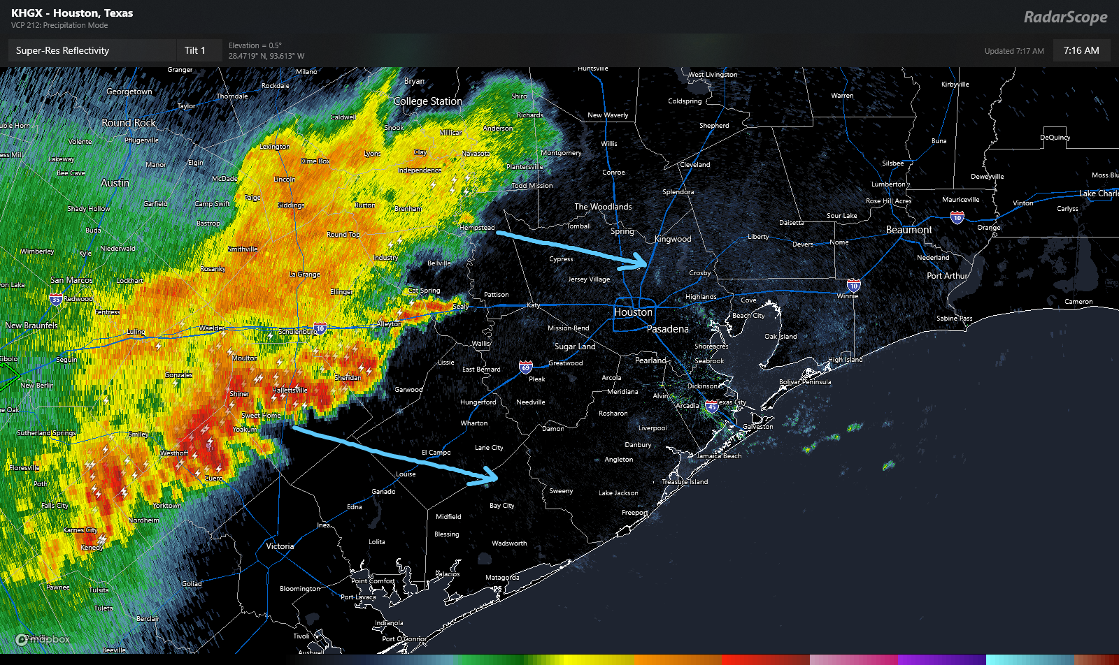
At this point, the storms are not severe, but they are producing heavy rain and lightning. Especially the southern part of the line, which is pushing through Shiner and moving toward El Campo. But other than the aforementioned rain and lightning, we don’t think these storms will cause significant problems.
What happens next? Models suggest this cluster of storms will weaken further as it approaches Houston. On the periphery, new storms may develop heading into afternoon. One or two of those storms could be on the stronger side, especially east of I-45 or along the coast. Outside of thunderstorms, expect some cloud cover at times. It’ll be warm with highs in the upper-80s.
Weekend
Tomorrow looks like it *may* be the quieter of the two weekend days. Expect an isolated shower or storm, but in general, the weather may behave much like we saw yesterday, where it’s mostly sun and clouds. Highs will be in the upper-80s to near 90 degrees.
Sunday is mildly more interesting. Models have been pretty consistent since yesterday in showing at least some kind of line of storms dropping in from the north during the late morning or afternoon. I don’t think that’ll be a big deal, but if you have outdoor plans Sunday just keep an eye on things. Otherwise, expect highs in the low-90s.
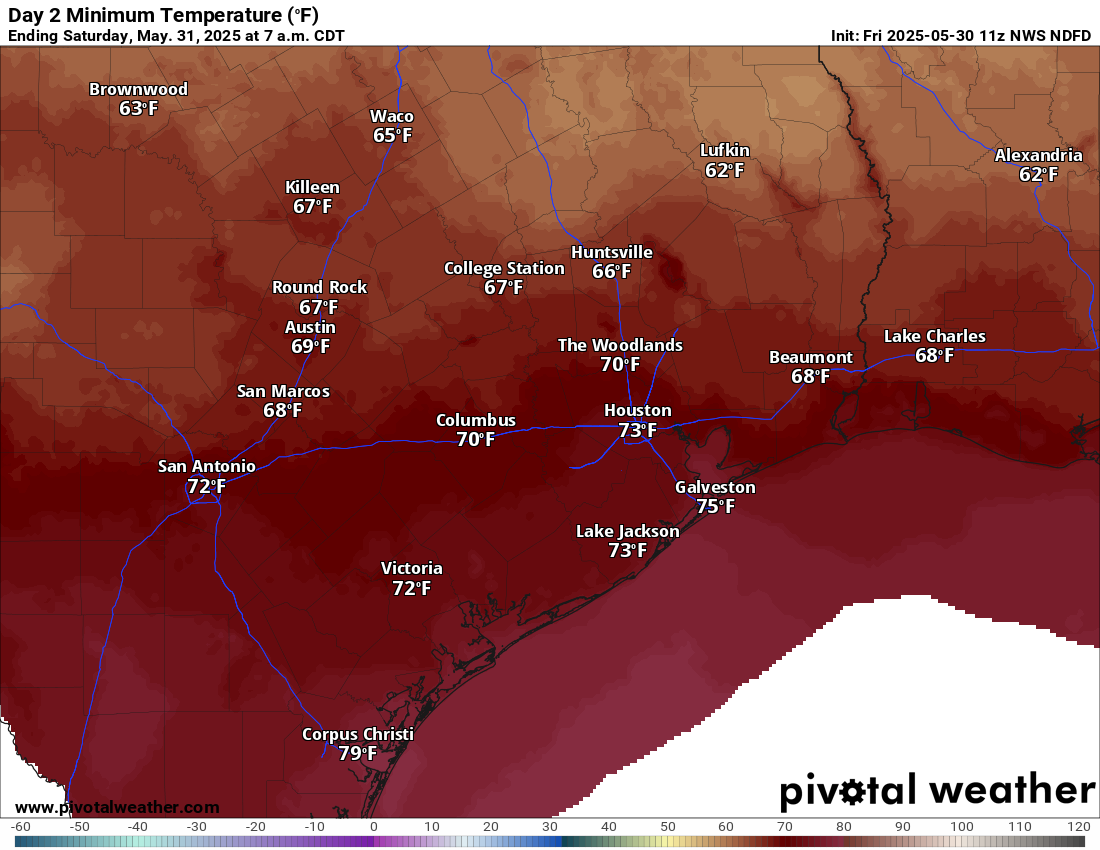
Humidity this weekend will be (relatively) lower compared to where it has been, allowing morning lows to dip into the 60s in a couple spots and low-70s away from the coast.
Next week
We should settle into a very June-like pattern next week. There will be a handful of shower chances sprinkled in through the week, but no one day looks worse than the others right now. Most days should be partly to mostly sunny. High temperatures will be in the low-90s, with low temperatures in the mid to upper-70s. The odds of mid-90s will increase later in the week.

Can you discuss the GFS’ cat 3/4 in the Gulf near NOLA around 10 June? Matt said (Eyewall) with a lot of tho radiosondes down/limited release/tech difficulties (Yale) that the directional accuracy these storms could be off by many miles (like 75 or more). Esp with the NOAA Hou/Gal office down 30%, Lake Charles down to 46%, Miami down to 60%, etc (Lowry).
Can you talk about some realistic limitations on the modeling bc I feel like we’re back in stone age 1960’s territory with 2025 enhanced conditions. Particularly concerned with rapid intensification.
Anything 10+ days out should be taken with a mountain of salt. GFS likes to spin everything into a hurricane that far out. Monitor things, but don’t take forecasts that far out with any certainty.
I hear you, but there’s been signaling for this going on for at least a week, plus strengthening of the models.
Ah, the hurricane hunters are already commenting 🙂 NHC shows zero for 7 days for the Atlantic region.
However, check the Eastern Pacific at NHC. The first named (tropical) storm, Alvin, is moving along. Chasing behind it, is a newly formed Depression, which is at 20% for 7 days (0% for 2 days).
While certainly not out of the realm of possibility, the GFS modeling tends to hallucinate this early in the season.
The GFS is doing GFS things in late May. I would pay it no heed at this time.
New GFS run has it slamming into the tip of Florida. We’re so far out that it changes hundreds of miles per run, I’m not going to worry about it until a few more days.
ECMWF using Ventuski shows nothing.
Saharan dust?
Cathy c: Yes, looks like a decent amount of it in the Atlantic.
This weather forecasting business is not easy but here I go again. My complex algorithm that factors things like the MJO, PMM, ENSO, Solar Activity, Weather lore and a half dozen other oscillations comes up with this for June:
It’s going to be a pretty much normal June for Southeast Texas. Temperatures near normal (0 to one degree above our historical norm due mostly to the urban heat island effect). Precipitation is going to be slightly above our normal as well.
You heard it here first. This complex weather algorithm will be available for a price as soon as I get it dialed in and skill scores out perform the GFS. (Which won’t be hard).
Overnight lows will continue to be warmer than normal here along the coast due to the warmer Gulf. Dew point levels will likely remain well above normal like they have been for over 2 weeks. In English, that means it will feel more muggy and miserable, which makes an innocent 89 to 90 degrees much more dangerous for outdoor physical activities.
SST anomalies for most of the Gulf are about 1 degree above normal for this time of the year. Nothing too crazy.
I have on mosquito spray inside the house.
Tell me you’re from Houston without telling me you’re from Houston (especially in June).
Shoot, believe it or not I was being attacked by swarms of those little vampires back in February of 2024 while trying to walk across the San Bernard Wildlife refuge. I couldn’t believe how many mosquitoes there were in February and it was a cold morning in 30s a few hours prior. I was practically breathing them in there was so many. I had to soak myself in mosquito spray. They must have burrowed together inside the thick brush and weeds around the refuge to stay warm enough to survive.
Should we be looking at Alvin (or any other Pacific hurricane)? I ask wondering if they can cross Mexico from the west and strengthen over Gulf to reach Houston/LA?
Me, personally … highly doubt that Alvin will pass across. The NHC shows it weakening Sat am and continuing to weaken day after day.
Anyway, to answer your question – yes, hurricanes and such can cross from the Atlantic side to Eastern Pacific and vice-versa. As a matter of fact, there is a Wiki webpage that is dedicated to this crossover. It includes a list of past crossovers,
Just do a Google search for:
wiki List of Atlantic Pacific crossover hurricanes
As Aggie said, it can happen.
But it’s not happening with Alvin. Yesterday’s post on The Eyewall details the storm’s likely path northward into Arizona.
I miss the days when we didn’t have to worry about mid to upper 90s until July or August.
When was that? I’ve lived in the Houston-Galveston area since 1964. I remember mid to upper 90s in early May during the Offshore Technology Conference. It was damn hot walking across the Astrodome parking lot.
It’s everyone’s short term memory playing tricks on them in combination of the constant bombardment of climate news constantly swirling making people believe everything is too early or too late in the season for heat, cold, rain, snow, and wind. we are biased to recent events and cannot fathom how nostalgia sways us to believe weather today is that much worse than it was 10, 20, 30, or even 40 years ago.
I’ve been here my entire life and we can expect mid to upper 90’s anytime from June – August. It may be slightly more common due to urban sprawl and climate change but it’s never been a rare event…
My mid-June Birthdays were constantly into the high 90s so much that basically every single one was at the pool or in the backyard with slip-n-slides. Definitely not just a modern thing.
Catching hell in Santa Fe right now!
Feels like there’s a forcefield over Jersey Village.
So glad weather is looking clear tomorrow, planning a beach day with some friends and we lucked out on the day!
I hope the weather will be nice this weekend. I’m going on a picnic at Bolivar Beach this Saturday. We’ll go fishing and have an outdoor BBQ together. If the weather is too bad, it might be a long time before we can all gather again for the next trip.
For those who think mid-upper 90’s is rare for May in Houston:
1902 highest May Temp was 95
1904 – 97
1906 – 98
1911 – 97
The list goes on and on. It’s not at all uncommon for mid to upper 90’s in May for Houston, Texas…