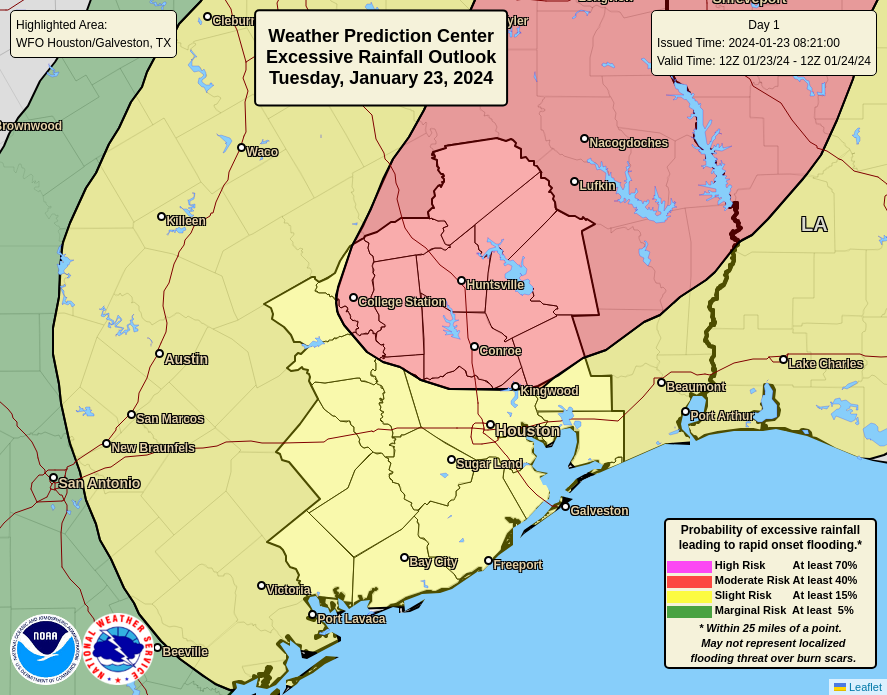
Summary: The Houston area picked up 1 to 4 inches of rainfall on Monday, and we’ll see ongoing bursts of precipitation through Thursday morning. Today the focus shifts north of the metro area, to areas including The Woodlands, Kingwood, and College Station. By Wednesday morning the threat appears to be more centered on coastal areas, including Galveston. We’re maintaining a Stage 1 flood alert for now, but will continue to monitor things closely.
Tuesday
Things are fairly quiet just before sunrise this morning, but showers and thunderstorms are developing to the west of the area in response to disturbance that will move through the region today. This feature will likely bring 1 to 4 inches of rain to areas north of Interstate 10, with the highest totals likely near locations such as College Station and Huntsville. In Houston I expect a somewhat calmer day, with 1 inch of rain or less in the city on down to the coast.
Temperature-wise, today will be fairly warm for January, with highs of about 70 degrees. Skies will be cloudy, with southeasterly winds occasionally gusting to 15 or 20 mph. Low temperatures tonight will only drop into the mid-60s, with continued humid air. Storms will be possible after midnight in the metro area, which I’ll discuss below.
Wednesday
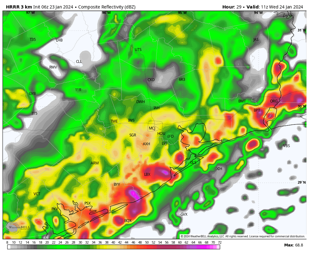
High-resolution models are indicating the development of strong showers and thunderstorms early on Wednesday morning for locations along and south of Interstate 10. While we cannot have great confidence yet, it does look like coastal areas from Port Lavaca to Galveston to Beaumont could see heavy rainfall during the pre-sunrise hours. Some of these storms could well migrate northward into the Houston metro area, setting up the potential for a messy commute on Wednesday morning.
In any case, unlike Tuesday, Wednesday looks rather wet in the Houston urban area, with the potential for street flooding. If there’s more clarity later today we may post an update. I expect additional accumulations of 2 to 4 inches of rain, with higher totals possible near and along the coast. It will be another warm-ish and humid day for most of Houston, with highs of about 70 degrees, but it may be a bit cooler to the northwest of the city.
Thursday
A weak front that will move into the Houston region and stall northwest of the area should finally push through the city early on Thursday morning. I expect this to drive one more round of showers and thunderstorms during the pre-dawn hours before this mess finally exits to the east. Look for partly clearing skies later in the day with highs in the 60s. Lows on Thursday night should drop into the 50s.
Friday
Expect a partly sunny day with highs of around 70 degrees. We’ll see a chance of showers later on Friday and Friday night as a second, stronger front approaches the area. Right now accumulations don’t look too significant, but we’ll see.
Saturday and Sunday
The weekend should see mostly sunny, winter-like weather. Look for highs in the mid-60s on Saturday, with a northerly wind gusting at times to 20 or 25 mph. Lows drop into the 40s overnight, with highs on Sunday reaching the lower 60s. I’m looking forward to taking advantage of the sunnier and mild weather with a long bike ride.
Next week
Look for calm weather to prevail through Wednesday, with highs generally in the 60s and lows in the 40s. A warming trend begins later on Wednesday or Thursday with some slight rain chances returning by Thursday or so. All in all, it should provide a nice run of pleasant weather after this turbulent week.


What an ugly week. Bring back the cool temps, not this gross humid mess in January.
Space City Weather is invaluable!
Thanks!
Would be interested to hear an update on the drought conditions across Texas we heard so much about months ago.
The drought in our region is almost completely gone. Scattered locations are still in D0 like Wharton, Fortbend, and parts of Harris County. Overall we are in much better shape than we were at the end of last summer. 👍
Joseph got it right. US drought monitor is back to no drought currently. But I would like to add that we are 36” below “normal rainfall” for Hobby counting years 2022, 2023 in total. So for Wayne’s water well we’ve got some long way to go….unless the new normal is much drier than last 30 years. We’ll see.
For my area, looks like they’re expecting less rain today compared to their forecast yesterday, but way more rain on Wednesday. I don’t think that descriptions like “the city” or “the Houston urban area” or helpful–first, because our area is so huge and second, because people who haven’t lived here for long won’t know what you mean. For a forecast for a specific area, one can go the the national weather service website https://www.weather.gov/ and put in a zip code and click “go”; then, for expected rainfall, scroll down and click on “hourly weather forecast” to get rainfall forecasts by time of day for that zip code.
If so dissatisfied with Eric and Matt, perhaps you can turn to the TV meteorologists whose forecasts reference….wait for it…”the city,” “the westside,” “north of town,” “the greater Houston region,” etc.
Pardon me for expecting more from SpaceCityWeather than from “TV meteorologists.” I’ve found the zip code forecast function of the National Weather Service to be quite useful.
Hard, defined “boundaries” in these point forecasts are seldom much better than their qualitative analogs being discussed here. Precipitation knows no boundaries, per se, on such a local level and no model can resolve such with decent reliability.
If your not satisfied with information ln this site, there several other weather sites to go to. Looks like the NWS has suited your needs
I tried to leave a comment with a link to the national weather service website but I guess it was blocked. The website is: forecast-dot-weather-dot-gov; replace “-dot-” with periods. You can put in a zip code and then click “go.” Then scroll down and click “hourly weather forecast” and you can see rainfall amounts forecast for each hour.
We moderate posts with URLs in them, for anti-spam and safety reasons – they require approval, which usually doesn’t happen immediately.
Please tell us your occupation and where you work so we can nitpick your performance and then hang a banner at your business so your customers know elsewhere to go for claimed better service that is actually much inferior.
I posted the link to the zip code forecast for the National Weather Service because some people might find it useful. In my own occupation, I appreciate thoughtful suggestions for improvement.
There are plenty of other weather sites to search for the info your specifically looking for
The “no hype” weather is turning into a daily college course in meteorology. Just want to know rain or shine? Flooding or not. Just a suggestion.
There is a summary at the beginning of each post so not even need to skip past anything.
I did take meteorology in college, and trust me, no this isn’t.
I’d rather be sun burnt on the lake, fighting skeeters and fighting a water moccasin with a flip-flop than have that cold weather we had last week!
Space City Weather is best. For years now.
Ignore Tanstaaflu and Tog.
Eric and Matt – you rock
Thank you for reliable weather posts