In brief: After more than four months, Houston’s overnight temperature has once again reached 65 degrees, which we consider the threshold for a fall-like night in the city. Accordingly, we’re celebrating Fall Day today! Houston’s temperatures will warm up quickly, but our air will remain dry through the weekend. Rain chances are near zero for at least the next five days.
Yes, it’s Fall Day
The first half of this summer was moderate, temperature-wise. But some of this ‘cooler’ weather was driven by Hurricane Beryl, which uprooted many trees and led to a prolonged, widespread power outages. Then, for much of August (remember that stretch of seven straight 100-degree days?) and September, Houston has experienced warmer than normal conditions. So yes, we’re due for a break.
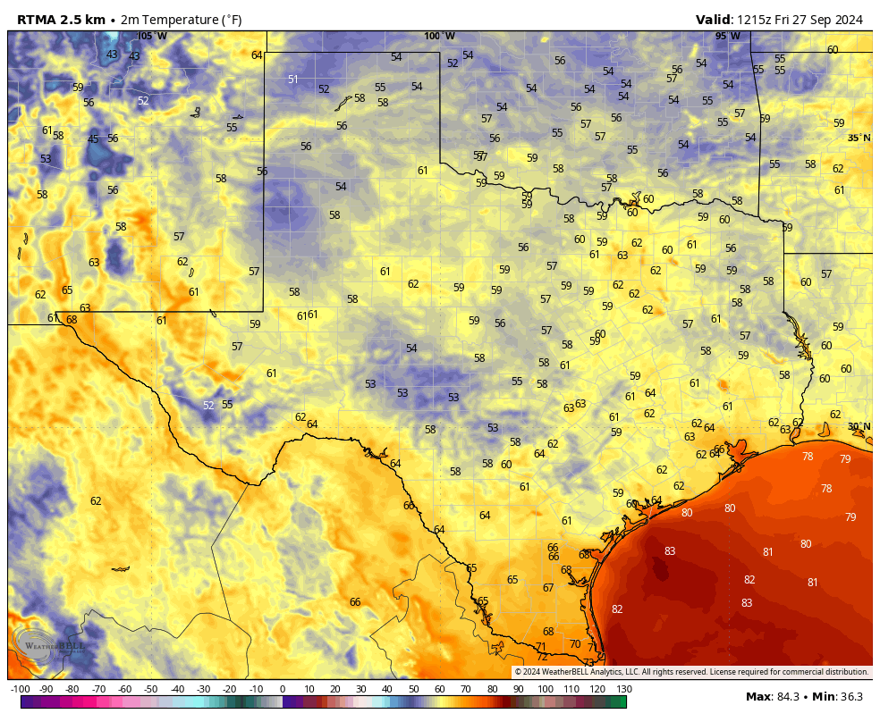
That came this week, in the form of our region’s second front. Low temperatures at Bush Intercontinental Airport fell to 64 degrees this morning, the first time since May 18 that the city has recorded a low of 65 degrees or below. We therefore decree today to be Fall Day in Houston, and I hope you take a moment to celebrate it outside. No, the weather isn’t going to be particularly cool. But the air will feel much drier than is typical during summer in Houston.
Friday
For a few hours this afternoon it won’t feel much like fall, as much of Houston is likely to climb into the upper 80s or even reach 90 degrees. But with dewpoints dropping into the lower 50s, the air will feel fine. Winds will be from the north-northwest at 5 to 10 mph, and skies will be clear. Low temperatures tonight will likely be a degree or two warmer than Thursday night, dropping into the upper 60s for most locations in Houston, with slightly cooler weather outside the city.
Saturday and Sunday
Expect sunny skies and warm days, with high temperatures in the low- to mid-90s. However, moderately drier air will take some of the sting out of the heat, and with lower humidity mornings and evenings will be pleasant. Expect low temperatures to drop to around 70 degrees. Rain chances are approximately zero percent.
Next week
Sunshine and warmth prevails through the first half of the week, with daytime highs generally in the mid-90s. This is pretty warm for late September and early October, but it’s being fueled partly by slightly drier air than normal. So while it will be hot, I wouldn’t characterize conditions as sweltering. Nighttime lows drop into the low 70s.
During the second half of the week we probably will see the onset of some more clouds, and some modest rain chances return to the forecast. At some point, perhaps over the weekend, another front will make a run at pushing all the way to the coast. I don’t have enough confidence in the forecast to predict when, but at some point within 7 to 10 days from now I’d expect cooler weather to return. We’ll see.
Tropics
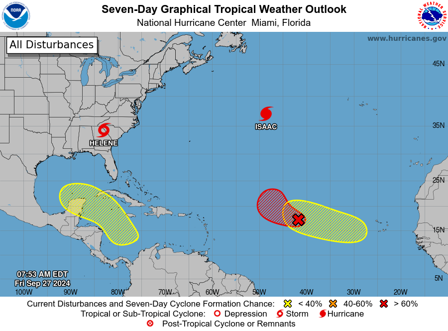
After making landfall on Thursday night in northern Florida, Helene has pushed well inland and is now ravaging the southeastern United States with heavy rain and gusty winds. It’s creating an awful mess. As we look deeper into the tropics, the National Hurricane Center is calling attention to an area of low pressure in the southern Caribbean Sea that could eventually develop into a tropical storm. This is something we will, of course, be watching. However, there is no real indication at this point that an organized system is ultimately going to track toward the Texas coast.

Woke up to go on the morning walk (about 6:45), and checked the weather … 58 (yes, 58°) degrees up here in Magnolia!! I was in disbelief, so clicked on “choose another PWS”, and yea, it showed about 20 PWS’es in our immediate area and all we’re in agreement. So nice and oddly cool.
It’s a shame what Helene is doing on the southeast US.
🎃 time !!
Yes! #halloweeneveryday
Here we go again with a tropical storm in the Caribbean!!!!
Funfact: our latest 100 degree day on record happened on this day back in 2005. This was partly due to our region being on the dry westside of Hurricane Rita. The next day we had heat index values over 110+. That was one of our more relentless summers.
Nearly 20 years later and I still regret evacuating for that storm. Spent 28 hours on I-10 only to make it to Sealy. Never again
Enjoyed an absolutely glorious wake up with a cup of coffee on the patio.
And alot of Survivors Guilt after checking in with colleagues in FL.
We tried to go north to family that live in Longview area. Made it from Missouri City to FM1960 and US59 (45 miles) in 40 minutes. That is where the mess started. Made it maybe 15 more miles over next 5 or 6 hours. Realizing that we were not going to get anywhere, AND were running out of gas, we decided to turn around and go home. No problem getting home, and no problems from the storm. Maybe .25″ of rain and not much wind as the storm was far enough to the east to not have much effect at my home.
Had we actually go further north, we would have been part of the huge mess in Lufkin, which I believe ended up with something like 100,000 people stranded there with no gas or food, and was actually where the storm tracked over. Turning around and going back home was one of the smartest decisions I ever made….
Yeah that whole situation was a total joke. Alot of people died from that evacuation.
I’m waiting for highs in the 70’s lows in the 50s area wide for my fall day. Nevertheless, I’ll take it as we inch forward towards fall. Mid 90s next week is what for many makes September worse than August.
Questions. 1. Is it true that the reason “there’s no real indication an organized system is ultimately going to track toward the Texas coast” is because the models are unreliable that far in the future? 2. Does Houston have the same (really low) risk as it did during the pre-formation of Helene?
Likely will need to wait until the meteorologists start interpreting data. Early GFS runs yesterday have something around the 5th-7ths heading towards Florida again. This morning it looks like the modeling shows it hitting mexico as a cat1 or tropical storm. I think it’s a bit too early to tell. As we get cooler weather that does help to keep these things at bay, but best to way until Eric and Matt have time to interpret.
Maybe this cool front is not quite cool enough or long lived enough to be a solid factor that keeps tropical weather away from us..
In 2022, the latter half of September saw every morning cool(ish) for those last two weeks…2023,I don’t remember anything robustly cool, that stuck, till closer to November…
Currently we are still having highs near 90, despite the cooler mornings..But again there may be other air currents, energy that wants to keep tropical mischief away from us at this time of year..I’m no expert with weather..
Here’s to hoping we will repel the tropical storms and hurricanes…
Unfortunately it won’t stop others taking early models as the truth rather than wait until if any storm forms to see where tracking takes it
Fall Day? Fall Day! Happy birthday to meeeeee!
Have a bunch of friends in the mountains of North Carolina who are getting absolutely hammered by Helene this morning. Expecting anywhere from 12 to 15 inches of rain. One text said, “Trees coming down in woods sound like cannon going off.” To say they are not accustomed to such weather is an understatement.
I really can’t think of a day when it is 90 degrees outside to be “fall”. I would call the first day of fall the day it gets no hotter than 80. Well, that would still be summer where I grew up since the average early July high was low 80s.
I’ll gladly take the Fall Day designation – primarily to wave goodbye to summer and also there’s the promise of MORE days with cooler temps in the near future.
I am not one to look a gift horse in the mouth.
what qualifies as „long run“?