In brief: After Houston’s hottest summer day so far, more heat is likely to persist today through Thursday. A tropical disturbance (that will not develop) will bring ample rain and storm chances back to the area Friday and Saturday before we jump right back into the hot stuff next week.
Summer to date in context
Since the weather is pretty cut and dry the next few days, let’s talk briefly about this summer. Officially, yesterday was our hottest day of the year, with a daily average of 89 degrees at Bush Airport, besting the 88.5° we hit 4 times, last on June 21st. But someone messaged us on Instagram recently asking if it was a pretty mild summer so far. “I’ve been able to enjoy the mornings and evenings outside which hasn’t always been the case,” they noted. And, I had to agree! It’s been hot, just as every summer is, but we’ve had enough rain chances (almost daily it seems) to break it up. It’s felt kind of like what would be a typical Houston summer.
And then Lee Corso barged in and said, “Not so fast, my friend.”
Statistically, from June 1st through Sunday, this has been the 7th hottest summer on record to date in Houston. In fact, we’re even a smidge hotter than 2024, though significantly trailing 2022 and 2023 to this point. We have averaged 84.9 degrees officially. This is about a solid 2 degrees warmer than normal. So why has it seemed less intense? In a word, the daytimes. Our daily high temperatures average 19th hottest on record. In other words, although this is one of Houston’s hottest summers on record to date, it hasn’t been that bad during the daytime. So it hasn’t seemed too intense. And on the days that it has been bad, we’ve often had rain showers to punctuate things. However, if you look at nighttime lows? It’s the 3rd warmest summer on record to date, trailing only 2022 and 2023 and only one spot ahead of 2024. Notice a pattern?

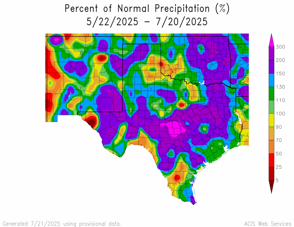
So factor it all together: Modestly hot days, punctuated by daily thunderstorms, followed by a bunch of persistently warm nights, and you get the seventh hottest summer to date in Houston that doesn’t feel all that terrible. It’s a weird outcome, but the numbers don’t lie.
Today through Thursday
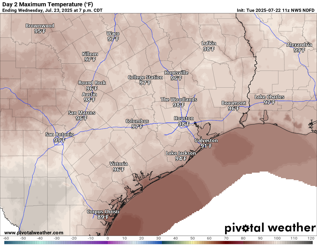
Look for the heat to keep up the next 2 to 3 days. Each day will probably top off in the mid to upper 90s. I would not be the least bit surprised to see a few spots hit 100 degrees before Thursday is out. Given that this is the hottest weather we’ve had in a month and the hottest of summer, give yourself a little grace out there and take it easy, stay hydrated, check on pets, check on the elderly, and always check the backseat before you lock the car.

Friday and Saturday
The remnants of our old friend, Invest 93L are diving into the Florida Peninsula today. This system will enter the northwest Gulf on Wednesday, track west on Thursday, and it will probably come ashore between Matagorda Bay and Cameron, Louisiana on Friday. No development is expected, as wind shear is too hostile, and dry air is likely available for disruption. But, what it will do is pick up our shower and storm chances to close the week and start the weekend.

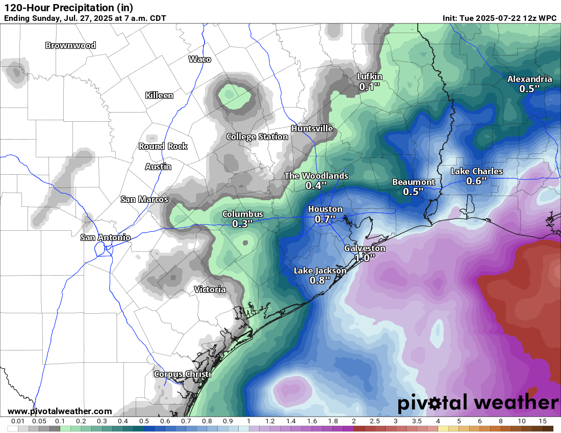
We are probably looking at a 40 to 60 percent chance of showers and storms on Friday and Saturday. This will allow high temps to plunge back into the low-90s. With enough clouds and rain, we may only make it to 90 degrees on either day in a few spots. In terms of total rainfall, it will not be uniform, as some areas will see modest amounts or little rain, while a few other locations could pick up 1 to 3 inches of rain, probably east of Houston or closer to the coast it seems right now. More on this tomorrow and Thursday.
Sunday into next week
That disturbance will exit on Sunday, lowering rain chances again. I would expect highs to return to the mid-90s by Sunday and then upper-90s at times next week, as a monster ridge of high pressure sets up over the Southern Plains. We will probably flirt with the hottest weather of summer again for much of next week.

So what is keeping the temperatures higher in the evening and more moderate in the afternoon? Are we generally seeing greater cloud cover or higher moisture than normal?
Yes
Higher moisture & humidity as a result of a warm Gulf. Some degree of urban heat island, but it can only explain a small amount (why in the last 4 years vs. the last 30). Nighttime low temperatures increasing are a hallmark of climate change as well.
Definitely, and I’ll also point out that even though it hasn’t been terribly brutal in Houston this summer, large portions of the United States have been baking under record smashing heatwaves since late June. In Europe, over 2,000 people have died as a result of a severe heatwave that started in late June. It’s not looking pretty for the future, I’m afraid.
Like setting bait! Cue all the useful comments on Gulf warm. As if we hadn’t read those before. Rain this weekend sounds wonderful. What a glorious summer this year.
Something something heat island effect?
That’s true for big cities but nights have been averaging much warmer than normal in rural areas as well especially along the immediate coast.
Just a thought…Does the heat generated by the many urban heat islands stay in the cities or does it radiate out to rural areas as well?
This is what I have been saying. This summer has been realitively mild when compared to 2022 and 2023, but it is still well above the 30 year average. And the warmer overnight lows continue to be consistent with the effects of excess greenhouse gasses and a warming Gulf. And remember the 2nd half of this past May was sweltering with record overnight lows in the 80s. We are still not in good shape right now.
This summer and the summer of 2021 were about as mild as it can get around here anymore with the modern warming Earth we are living in now. Saldy it will come a day where the summers like 2023 and 2011 will be commonplace.
We need to do hourly temperatures and average 24 temps vs just taking the high and lows for the day. This greatly skews the numbers and isnt representative of a good average daily temp.
I guess? But you’d have to go back and do that for every day of the last 30 yrs, if the objective is to compare the present to the past. I don’t have that kind of time, myself.
Just from the research of hourly temperatures I have done in our region at each station, I can already tell you it’s still averaging warmer in recent years.
Our weather is complex, there are likely many reasons for the warmer nighttime temps. Climate change, urban heat island and natural oscillations all play a role. The Atlantic Multidecadal Oscillation is a well documented ocean phenomenon that sees ocean temperatures in the Atlantic switch from a warmer cycle to a colder one every 50-80 years and It has been in its warmer phase since about 1997. Sooner or later it will switch back to a colder cycle and our nighttime temps may trend back closer to longer term norms.
Tik tok meteorology (which promotes some degree of weather awareness) is better than tik tok celebrity gossip, and sophomoric prank videos. People are where they are, education is and has been underfunded, but you want to feel morally superior because you’re booming in retirement, and grew up around a society that promoted literacy more. If you care so much about the approach to someone, or some platforms meteorology, then clamor for a society that promotes such pedagogy. You’re just punching down, and it is very gross.
“Tik tok (sic) meteorology…is better than tik tok (sic) celebrity gossip…”
Not if it causes panic due to misinformation, it isn’t.
Tik tok meteorology = oxymoron.
You’ve been yapping for two days now.
Go expel elsewhere.
I’m sensing a heated global warming debate that will exceed 70+ comments today.
and very productive and insightful TikTok “you should do this” commentary as well.
Don’t forget the “don’t talk bad about tiktok weather posters because they’re a product of their environment” comments…
Thinking it’s been mild, but learning it’s actually been the 7th hottest summer on record? We’re like frogs in a boiling pot of water.
Frogs must be smarter than humans; they will in fact hop out of a gradually rising pot of water, contrary to popular aphorisms.
& they don’t bother with tik tok either
The clouds giveth and the clouds taketh. lower highs, higher lows, and more humidity. I just don’t know if it’s even worth washing my car this summer.
I think the dewpoint temps have been lower too making the feels like numbers bearable.
Heat Index hasn’t passed 104, unlike last year 112 a few times. This year is mild. I walk nearly hour at 10am so notice how much sweat I have, last year Id have to change shirts.
The Accuweather app is much more melodramatic about tropical development in the Gulf later this week heading to the Texas coast. I guess it’s to get eyeballs on their app, which serves ads after all.
We maybe need term for avg 11am to 8pm temp, walking around hours, not just peak reached for 1 minute to then maybe quickly fall 5 degrees. And also include a 2nd measurement, the 11-8 heat index. And maybe 3rd a sun intensity measure, how hot in sunlight does it feel, sunlight seems to add 10 degrees vs being under shade trees at 85F. . . So officially “hottest” means peak temp for day, reached for at least 1 minutes?
The earth goes through a cycle how many years who knows we can guess lets take from the ice age to volcanoes creating land masses and everything else in between now we are living to see temp change per say but the world will take care of itself going through it cycles if we lived during the ice age times we be talking about that situation and that is the climate change I study on moons ago. For living close to the southern equator so far and we have not seen August yet it has been nice. Now living in the concrete jungle does kick up temps but since I retired and moved away from it, it makes a difference.
Ok Otzi
Hey, if this is what climate change feels like, maybe it won’t be so bad after all.
What does excess water vapor (NASA estimates a 4 to 6 fold increase since a certain event in the South Pacific) in the upper atmosphere do to surface temps?
P.S. I’m not personally seeking an answer, I’ve researched on my own.
The Hunga Tonga volcanic eruption definitely contributed to the warming and excess water vapor a little bit. Climate scientists have said this much, but the warming effects of that volcano were regional and minuscule in comparison to the continuous trend of warming on a global scale that we have been observing for decades before that eruption.
It turns out humans have produced far more greenhouse gasses into the atmosphere over the past 150 years than a spontaneous volcano eruption can.