In brief: Houston faces a wet Labor Day Weekend, but our flooding concerns are clustered primarily along the coast. Mostly cloudy skies will keep a lid on temperatures over the holiday weekend, keeping things dare I say almost comfortable outside most of the time? We are also tracking the tropics as they begin to heat up.
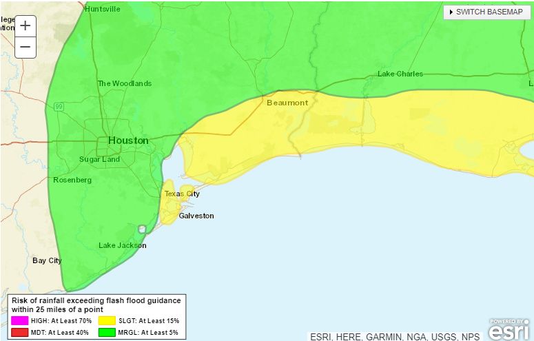
Good morning. We’re providing updates through this weekend on Space City Weather due to the ongoing potential for heavy rainfall through early next week. However, our Stage 1 flood alert remains in effect only for coastal counties, from Galveston County eastward. This is where our modeling continues to indicate the potential for some street flooding over the next several days. For example, here’s where the likelihood of heavy rainfall is greatest for today:
The rains into next week will be driven by an upper-level low pressure system lingering off the Texas coast. As we discussed on Friday, there is a small possibility this system develops tropical characteristics with a surface center of low pressure over the Labor Day weekend, but most likely its main impact will be as a rainmaker for coastal areas.
As often happens with these systems, the heavy rainfall is clustered mostly offshore. But areas such as Galveston Island and Bolivar Peninsula will be well within the threat area, and may pick up 5 or even 10 inches of rainfall through the middle of next week. It won’t rain all of the time, but coastal counties should expect a pretty decent soaking through about next Wednesday.
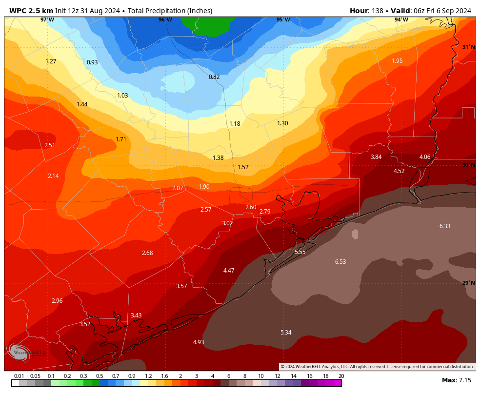
As for areas further inland, including most of the Houston metro area, showers will be hit or miss this weekend. Rain chances will depend on how far you live from the coast, but over the Labor Day weekend you can at least expect a healthy chance of a passing shower or thunderstorm each day. One benefit of the cloudy skies this weekend is cooler temperatures, particularly for the end of August and into early September. Highs, for the most part, will be in the upper 80s to about 90 degrees each day—and even cooler closer to the coast. Often, we’re 10 degrees hotter at this time of year.
Tropics
We’re starting to see activity pick up in the tropics. If you want a full rundown, please check The Eyewall later this morning, where Matt will have a comprehensive update on everything we know before noon today. In addition to the aforementioned system in the northwestern Gulf of Mexico, we’re also closely monitoring a tropical wave in the Central Atlantic. It will move into the Caribbean Sea early next week.
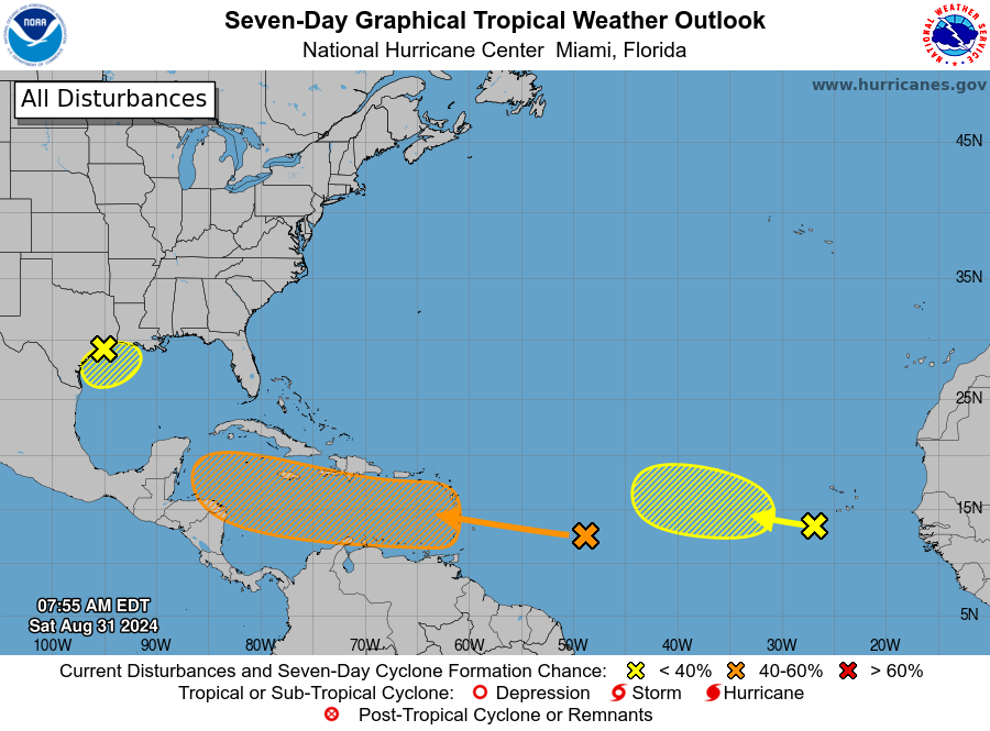
There it will find blazing hot seas, but at this time most of our modeling guidance is not too aggressive about developing it into a tropical storm or hurricane early next week. However, toward the end of next week this wave/tropical system will be nearing the western edge of the Caribbean Sea. After that point it could move into the Gulf of Mexico. We’re talking about a period 7 to 10 days from now, so uncertainty is very high. There’s not a whole lot we can say about what happens at that point, so we’ll continue to watch it.
Have a great Labor Day Weekend, everyone. We’ll be back with another post on Sunday morning to assess things.

With the “seven to ten days from now” what is that referring to? When it moves into the Gulf? Which, if something makes landfall, would be even more days?
Yes.
Eric is talking about the orange storm north of northeast South America.
This morning’s GFS run had to have been made up, Cat 1 hitting Brownsville then running the entire Texas coast passing Houston as a Cat 2 before slamming into SW Louisiana. All to maximize the area of damage to Texas, no doubt. But I wouldn’t put it past the weather gods this year.
I love the climate here soooo much…..
The models were different yesterday, will be different tomorrow
That’s what makes life here so much fun.
Lol, yeah I saw that. Yesterday it showed a cat 4 hitting Port Arthur, then Matagorda, then I think Port A. I thought, wow that’s not good.
Then it just decided to buzz cut the entire Tx Gulf Coast. Running the full gamut.
Now it looks like a disappearing act into Western Mexico.
I’m not discounting it. I realize this is impartial physics. But still, it feels almost like it wants to scare. Early Halloween (^_^)
Lol
*eastern Mexico
“There’s not a whole lot we can say about what happens at that point….Have a great Labor Day Weekend, everyone” That just sort of left me hanging in uncertainty. What the is the worse case scenario for us? I just want to be prepared. Thanks.
The worst case scenario is a powerful direct hit Hurricane like Harvey or Ike.
It’s currently thousands of miles away in the middle of the Atlantic ocean. There literally is nothing to say right now. It’s unreasonable to be asking for any scenario.
You live on the Gulf Coast and it’s hurricane season. You should always be prepared regardless.
That’s ridiculous. It’s never unreasonable to ask for information when the situation calls for it, which it does right now.
If it wasn’t important, SCW wouldn’t have posted this on a Saturday.
““There’s not a whole lot we can say about what happens at that point….Have a great Labor Day Weekend, everyone” That just sort of left me hanging in uncertainty.” Fairly or not, it’s times like this that make me question the efficacy of hurricane forecasting.
It’s posts like this that make me question the intelligence of the average human.
Remember: the standard IQ test averages at 100, meaning, half the population is above average and half below average. (I believe that last half are driving on Houston’s streets.)
Good grief, man — it going to shower in Houston a bit. That’s all.
The worst case is a category 5 making landfall at Freeport. Such a path and storm would effectively destroy Houston as we know it and cripple southeast Texas for decades.
Actually, I wouldn’t mind if Houston got hammered, as long as I am out of first first. Houston could do with a make-over. Maybe add more greenery in place of the concrete.
Sure, let’s ignore the potential suffering, damage and chain reaction of events if that occured.
As long as you’re safe, Ken.
Barbie, you must take life far too seriously.
You must be from Katy.
Should Katy evacuate?
The school board should.
Hey Eric. Any thoughts on a cold front in about 10 days? Some forecast models show lows in the low 60’s by Monday the 9th
‘but at this time most of our modeling guidance is not too aggressive about developing it into a tropical storm or hurricane early next week.’
That’ll change. It always does. The worst case scenario always happens in times like this.
No, it doesn’t. Just a couple weeks ago there was “something to watch” and it turned into nothing. If you’re concerned about the efficacy of forecasting, why should we think your forecast is effective?
It seems we in Houston are going to miss out on the rain yet again. Nearly half the weekend gone and not a drop.
You’re right about that Ken J. Here in Santa Fe the sun’s still shining and the wife and I keep wondering why all the hoopla about flash flood warnings.
And friends with a beach house in Matagorda travelled there yesterday ready to batten down the hatches expecting torrential downpours, and right now, Saturday, clear skies and sun shining. We have to take weather forecasts with a very large pinch of salt.
Well…so much for the break we have enjoyed from “when will that cloud near the Azores turn into a Cat 5 and what day will it hit 3 weeks from now? “
They (all weather sites I see and this own) were calling for a washout Labor Day weekend, and it’s sunny and hot here in virtually the entire grayer Houston area that holds almost all of the 7+ million people that live here. So they can’t get rainfall estimates even close to correct in a 48 hour window and you guys want them to accurately predict what’s long to happen with a tropical so disturbance thousands of miles away? Y’all give too much credit to the models and those interpreting the models.
We never worried about any heavy rains.
Look out your window … check the radar.
The rains right now are all over the New Orleans area. That’s not what we’d consider close to the Houston areas.
Quiet (weather wise) in Magnolia.