In brief: After one more day with storm-o-clock weather this afternoon, Houston will see a sunnier and hotter pattern set in through the first half of the weekend. We’re not going to get super-hot, but it will feel like June out there. By Sunday our attention turns to the Gulf of Mexico, and the potential for tropical rainfall much of next week.
Wednesday
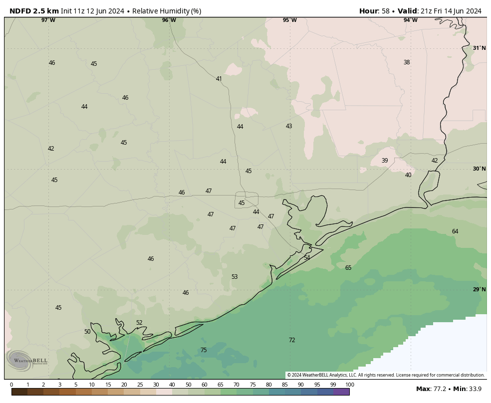
We’re going to see one more day with the potential for scattered to widespread showers and thunderstorms. Conditions will be similar to what we’ve seen on Monday and Tuesday, with storms firing up during the late morning, afternoon, and early evening hours due to a combination of plenty of moisture in the atmosphere, the sea breeze, and an overall perturbed atmosphere. Similar to the last couple of days, a few locations may see accumulations of 1 to 2 inches of rain, whereas most of the area sees considerably less.
Skies will be partly to mostly sunny when it’s not raining, with high temperatures reaching the low 90s for much of Houston. Outside of thunderstorms, winds will be light, around 5 mph from the northwest. Lows tonight will drop into the mid-70s.
Thursday
This will be a bit of a transition day as high pressure builds into our area from the northeast. I can’t rule out some isolated showers and thunderstorms, but most of us will see sunny skies with high temperatures in the low- to mid-90s. Lows will drop into the mid-70s.
Friday and Saturday
These will be sunny and hot days, with highs in the low-to-mid 90s. However, dewpoints will be a bit lower than a classic Houston summer, especially on Friday. This will take some of the sting out of the daytime highs, and make evenings a little more comfortable. Lows on Friday night could drop into the low 70s for much of Houston. Rain chances for both of these days are less than 10 percent.
Sunday and beyond
Starting on Sunday, our attention will need turn to the Southern Gulf of Mexico, where we could see some sort of tropical disturbance develop. Right now I don’t anticipate anything too organized—i.e. with strong, hurricane-force winds. However, whatever does develop is likely to be an efficient conveyor belt to bring Gulf moisture onshore, and therefore serve as a source of moderate to heavy tropical rainfall.
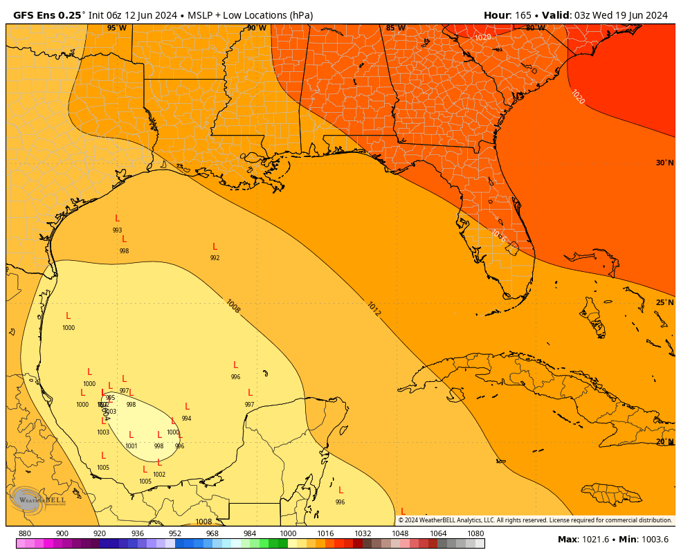
Our best forecast models are split on the evolution of this system, and how far north it moves (this will depend on the strength of high pressure over the southern United States). What I can say is that, beginning Sunday and especially from Monday through Thursday, there will be the potential for heavy rainfall along the Texas coast, including the greater Houston area.
It is a folly to try and predict rainfall totals because there are still so many uncertainties about a forecast for 5 to 10 days from now. But this is the kind of thing where our area could see 1 inch of rainfall, or 10 next week. In any case, most of next week should see a cloudier pattern, and this should help to limit highs in the upper 80s. Matt and I will be keeping a close eye on this, and when we know something, you will.

I was wondering if you guys noticed this, but the storms last night all seemed to be going different directions. I noticed that some would even rotate (in a non tornadic way). One storm would pop up from the south and move up to the north. Another would pop up in the north and move southeast. Was wondering you guys know what was happening there?
CH13 was saying that storms themselves were producing cooler winds which in turn also produced its own line of storms. They had a cool radar showing the outline of these.
Various boundaries in play yesterday, including the sea breeze, an MCS moving into the region from the central part of the state, and outflow boundaries from the various storms had things moving in a variety of directions.
Storms? Haven’t had a drop of rain here all week.
I’m very curious/concerned about rainfall in Galveston next week and if we need to alter vacation plans to bed there. Rain is fine, but excessive rain and flooding is another….
“ It is a folly to try and predict rainfall totals because there are still so many uncertainties about a forecast for 5 to 10 days from now. But this is the kind of thing where our area could see 1 inch of rainfall, or 10 next week. In any case, most of next week should see a cloudier pattern, and this should help to limit highs in the upper 80s. Matt and I will be keeping a close eye on this, and when we know something, you will.” — Space City Weather
I hope that helps.
I just put new sod down at my house so next week’s rain is welcome! Water from the city of Houston is silly expensive these days.
Why would you put down new grass in June in Houston?
When will it be clearer whether next week’s event will deliver a manageable amount of rain to the urban core of Houston, or cause a dangerous flood?
This weekend
I’m getting married the 22nd so i am hoping Friday and Saturday the rain and possibility of flooding will subside, specially for our out of town guests whom are not familiar with the area and heavy rains. crosses fingers
Congrats! I got married last year on 7/8 and kept close tabs on SCW in the days and weeks that preceded the wedding. We lucked out with a rain-free day (after 4+ inches fell two days earlier). Hoping you get a dry wedding too!
According to the Centers for Disease Prevention and Control (CDC), the current divorce rate nationwide is around 42%. Other quick facts about divorce in the U.S. include: There are 86 divorces every hour, compared to 230 marriages an hour.
Just thought you would like to know what your married longevity might be.
I hope you buck the trend. 🙂
Might the storms head up Lake Livingston way on Monday?
Last year on this day is when our 4 months of hell began with no real let up until early October. I’m glad to see that the brutal heat will be delayed a bit this year by possible tropical rains.
I like to think of this tropical disturbance situation as a full-dress rehearsal for the usual hurricane season (and life) advice: “prepare for the worst and hope for the best”.
There is no crystal ball to tell us where and how much rain will come down. So, we calculate the risks individually and take action according to our personal comfort level.
If you stock up supplies, gas up your tank, and refill your meds, the worst that could happen if the rain event is a bust is that you have a full pantry, gas tank, and all of your meds.
Like Joseph, I’m glad to see some possible tropical rains to dampen the temperatures. Each day under 95 degrees is a good thing.
Having power is even better. Enough rain. Enough storms.
rain only causes power issues when the storms are too strong, otherwise it is normal and needed. Try moving to the desert if u dont like rain
This is the warm up for the two major hurricanes I’m convinced are going to hit Houston this yaer.
Day two of possible “widespread showers and thunderstorms. Conditions will be similar to what we’ve seen on Monday and Tuesday, with storms firing up during the late morning, afternoon, and early evening hours …”
Yesterday, not a drop of rain, as with today. Yesterday, the rain clouds suddenly shifted to the east of us (we’re in Magnolia), then to the south.
Today, the rains were approaching us in Magnolia, they suddenly shifted to the west, then moved to the south. Currently, the line of rain is from Rosenberg down to Matagorda, moving straight down. Bummed we didn’t get any rain.
When SPW shows the temp for Houston is that temp at IAH or elsewhere. I notice that Accuweather app shows temp for Uptown where I live and it can vary significantly from IAH. Thanks. Read you first and last.