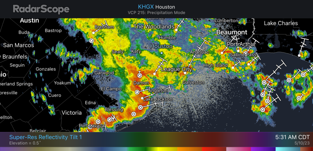
A slowly-moving low pressure system is bringing a band of heavy rainfall into the Houston region this morning. As of 5:30 am CT the main line of storms remains southwest of the city, from Sealy to Needville to Lake Jackson. The heaviest of these showers and thunderstorms will slowly progress into the Houston area this over the next few hours, affecting the morning commute, before clearing out during the late morning hours. Based on current radar trends, the highest rain accumulations are likely to be along, and south of Interstate 10.
These storms will bring widespread accumulations of 1 to 3 inches of rain, with the potential for 5 inches or more in isolated areas. This will flood at least some low-lying streets, with the potential for flash flooding where rainfall is heaviest this morning. For this reason we are maintaining a Stage 2 flood alert for our area until the early afternoon hours. After that time we are highly confident the threat will end. Please take care when you are out and about this morning.
Wednesday
As rains wind down later this morning, and into the afternoon hours, clouds will remain omnipresent. This should help to limit high temperatures this afternoon to about 80 degrees, which certainly will be the region’s coolest day for awhile. Rain chances tonight will drop to near zero, with a low in the low-70s.
Thursday and Friday
These will be a pair of similarly warm and humid days, with high temperatures in the mid- to upper-80s, and the possibility for a bit of sunshine during the afternoon hours. Winds will generally be out of the south at 10 to 15 mph. While we cannot rule out precipitation, overall rain chances are only about 20 percent, and accumulations will be slight.
Saturday and Sunday
The weekend, I’m afraid, won’t bring much sunshine. Instead we’ll see continued high temperatures in the mid- to upper-80s with muggy air, and mostly cloudy skies. The trickier question is rainfall. At this time, due to the expected location of an atmospheric disturbance over central Texas, there looks to be a sharp east-west gradient in rainfall. Therefore we could see a situation where areas roughly east of Interstate 45 see perhaps only a tenth of an inch of rain, or two, and areas near and west of Katy see upwards of 1 inch. In terms of timing, the best chances of rainfall will come from the period of Saturday afternoon through Sunday.
Next week
A fairly weak front is going to work its way into Houston next week. It may be accompanied by some showers on Monday, and then some slightly drier air on Tuesday. Don’t have high expectations for this, but with dewpoints likely dropping back into the 60s it should feel a little bit less muggy outside. Highs should be in the mid-80s, with lows in the upper 60s to 70 degrees. We may see some sunshine, but rain chances won’t go away entirely.


What are the bars on the Radar Reflectivity map?
I think that’s where the radar expects the particular cells of thunderstorms to be in 15 minute increments
Thank you and could you get out your magic weather wand and see if we can have no rain, a slight drier breeze for HS graduation on the 19th! Thank you in advance-
I think you mean a magic marker, lol
Eight inches of rain so far this morning in Brookside Village
Actually about 3 1/2 inches now, read gauge wrong earlier ( it was 8 cm)
Over the last 2 days we had 3″ total rain in the Westchase area. Not bad, it all helps. 🙂
Street flooding on Gessner at 9:00am.
At least it isn’t the typical 90+ degrees of swamp weather we normally have, so I’ll take it!
Here in Sienna Steep Bank East, we have had 3.52″ fall since midnight according to my neighbors personal weather station. One blast at 2:30, one blast at 4:00, one blast at 5:30, and the monster blast at 6:30. Pool is up to the top of the overflow drain grating, almost to the bottom side of the capstones. Still raining, but a lot lighter. I am glad my yard drains well. Also glad that the wind has been less than 10 mph.
And the excitable dog index here is at least a 7.0 due to the thunder. Our little Coco does not like the thunder at all.
Be safe everyone! .
My little shi-poodle is terrified of storms, my Jack Russell is nonchalant about it all. Both ‘found’ dogs.
Our Coco is a Shih Tzu. She starts panting any more when she hears a leaf rattle and is terrified of rain, thunder, and lightning. .
Well, happy to report that there was much less rain ’round here in the Champions area today than was forecast. 0.82″ at my house; the National Weather Service forecast was for around 2.5″
Not too bad this morning. Healthy rain but it seemed manageable and no serious flooding. A little too much “hype” on this website lately