In brief: We have expanded a Stage 2 flood alert to cover the entire region today as a storm system passes through. The greatest likelihood of flooding appears to be to the southwest of Houston, but all areas will be vulnerable this morning.
Unfolding flooding event
As we look at the radar this morning we have one band of persistent storms over eastern Houston which has dropped as much as 3 inches of rain over Channelview, Baytown, and other locations since midnight (a flash flood warning is in effect for these locations until 7:30 am today). Much of the rest of the region has been spared, but additional storms loom to the west of our area, and we expect the potential for flash flooding through about noon today. Not all areas will be affected, certainly, but please take care driving into stronger storms, and do not attempt to drive through high water.
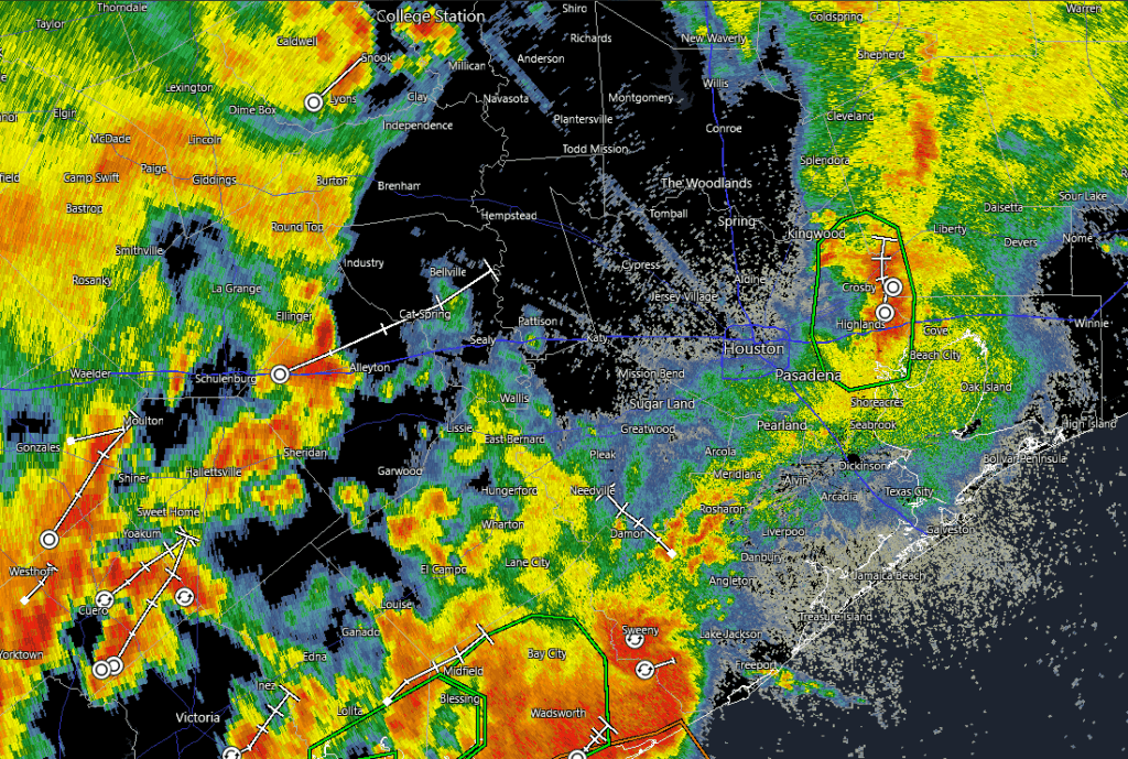
The strongest storms should move into the Houston region during a time period from around 7 am to noon, after which the heaviest rains will likely reach the coast and begin to push off shore and well to the east of Houston. During this morning we now believe the heaviest rainfall will occur along and south of Interstate 10, and are particularly concerned about the southwest quadrant of the Houston metro area. Much of our modeling predicts that Wharton, Brazoria, and southern Fort Bend counties are at risk of picking up 5 to 10 inches of rainfall.
Closer to Houston, particularly within the city limits and to the east of Interstate 45, totals should be less. Generally, most locations should pick up 1 to 4 inches of rainfall, but there will be the potential for higher bullseyes. Given that this storm system has the ability to produce high rainfall rates, streets may back up quickly and flash flooding is possible. For this reason, we are expanding our Stage 2 flood alert to cover the entire Houston region, which includes all surrounding counties. We should be able to drop this flood alert back to Stage 1 this afternoon.
Thursday
As noted above, we are seeing an atmosphere laden with moisture interact with a potent disturbance this morning, creating favorable conditions for heavy rainfall. The strongest storms should end by noon, but some isolated showers could persist into this afternoon. As a result of the rain and cloud cover, high temperatures today should top out in the mid-80s. Lows tonight will drop into the 70s, with a slight chance of showers and storms.
Friday
Some additional storm development is likely on Friday, and conditions may be most favorable for this closer to the coast. However, we cannot be sure about this. Overall, the pattern is a little bit less supportive of strong storms on Friday, and I don’t expect things to be as widespread or significant as Thursday, but the threat of heavy rainfall will nevertheless be there. Highs will be around 90 degrees, as skies should be partly sunny.

Saturday and Sunday
The weekend will continue to see a chance of showers and thunderstorms, although at this point I expect them to be more isolated in nature rather than widespread. So they should be hit and miss, and there should be mostly sunny skies for much of the day. Expect high temperatures in the lower 90s. If you have outdoor plans, there’s a chance they may be fine, although you can expect soils and fields to be sodden from this week’s rains.
Next week
I expect this pattern to continue for much of next week, with a decent chance of showers and thunderstorms on a daily basis to go along with mostly sunny skies and high temperatures in the lower 90s. At this point I don’t see the potential for significant flooding, as these will more likely be passing showers driven by the sea breeze with lower accumulations. But we’ll see, as it is June, when we are prone to higher rainfall rates. I do expect a chance of rain to remain in our forecast for awhile, perhaps the rest of the month, rather than seeing a robust ridge of high pressure cover the area.
We will update this forecast as needed today. Please be safe in the wet and inclement weather.

We got 2 inches of rain in Sweeny in less than an hour. There is high water in ditches and yards but nothing to serious.
Just picked up an additional 2 inches of rain. Water is now covering some streets, but fortunately, no houses have taken in any water.
It is good to know that the death ridge is going to hold off for a little bit and allow us to have a traditional June. I’m sure the death ridge will lay its wrath on us for the longhaul come July though. Enjoy the old school early summer weather while it lasts.
No evacuations. This isn’t anywhere close to that, but we trust Matt & Eric to let us know when to take caution. Today is a caution day, not a panic day. Welcome to Houston! 🙂
Dude. The excitable dog scale was off the charts last night!!!
In active weather like this I read the NWS area forecast discussion a few times a day. Has their frequency decreased with the staffing shortages? It seems like they used to be updated more often, especially late in the day/overnight, but I might be imagining that because I’m expecting service cuts.
Your comment is taken seriously; however, on this website, for the past few years (since 2005?, 2008?), there has been an inside, running joke with the followers on whether the town of Katy needs evacuate for Hurricane Ike and for other rain events.
Which was the result, I believe, of a serious post by a newcomer who had not experienced a hurricane before. I imagine half of metro Houston, or close to it, wasn’t here in 2008. Besides growth, a lot of people move into and out of Houston.
“And once the storm is over, you won’t remember how you made it through, how you managed to survive. You won’t even be sure, whether the storm is really over. But one thing is certain. When you come out of the storm, you won’t be the same person who walked in.” – Haruki Murakami
I love storms. Until they get names…
Not much happened in Clear Lake apart from rumbling thunder starting around 2 AM.. Only 1/2″ of rain and only a few occasional lighting strikes. Easy drive into work despite the rain, but of course Ch. 13 was going ballistic with one of their “hide under the bed” days.
OK, the lights did just flick here in the office, which is not good when you work in a chemical plant…
Am guessing there are a lots of readers who have had a much wetter experience than you this morning.
Um, we’ve had 2 inches of rain since 6am in the middle of Clear Lake…
10 inches around Palacious
No death ridge equals less heat but it also keeps the door open for tropical trouble makers.
As long as houses and cars dont flood, this is great news right? We want the ground as moist as possible for the summer?
Yes because the intense heat of the summer dries the ground very quickly. Timely rains are very important this time of year but of course not 50 inches all at once.
You could also have flooding with heavy rain occuring consecutive days that gets overlooked
Dark and wet in west Pearland but not bad (ie we still have power).
Does anyone know if it’s supposed to rain today in the Houston metro area? Super dry.
This has to be a drought buster for areas of the state for a few yrs that needs the rain badly and so far with out any major disasters.
I say hurrah! You that bemoan the heat so loudly should join in. If there are 16 weeks of summer, June – September, two weeks of rain and low nineties just cancelled 12.5% of it!
I will gladly take it as long as it’s not severe.
Rejoice people not for flooding of course nobody wants that, but we may go through the entire month of June just like this,that’s 1/4 of Summer already in the books.
And the Euro models are indicating that the ridge is going to stay north of us in the central plains, I’m sorry for them, but we need a break we’ve had three years of this stuff and I think we could use a break.
I completely agree with you!