Summary: On Tuesday and Tuesday night the axis of heavy rainfall fell over areas north of Houston, inundating locations such as College Station and Huntsville with 3 to 6 inches. But by early Wednesday morning, as anticipated, the focus has shifted southward into Houston and down to the coast. On-and-off showers and thunderstorms can be expected for much of today in those areas. This will cause street flooding in some locations and care should be taken. A Stage 1 flood alert remains in effect for today and tonight.
Wednesday
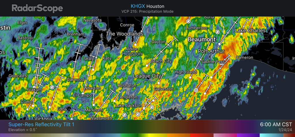
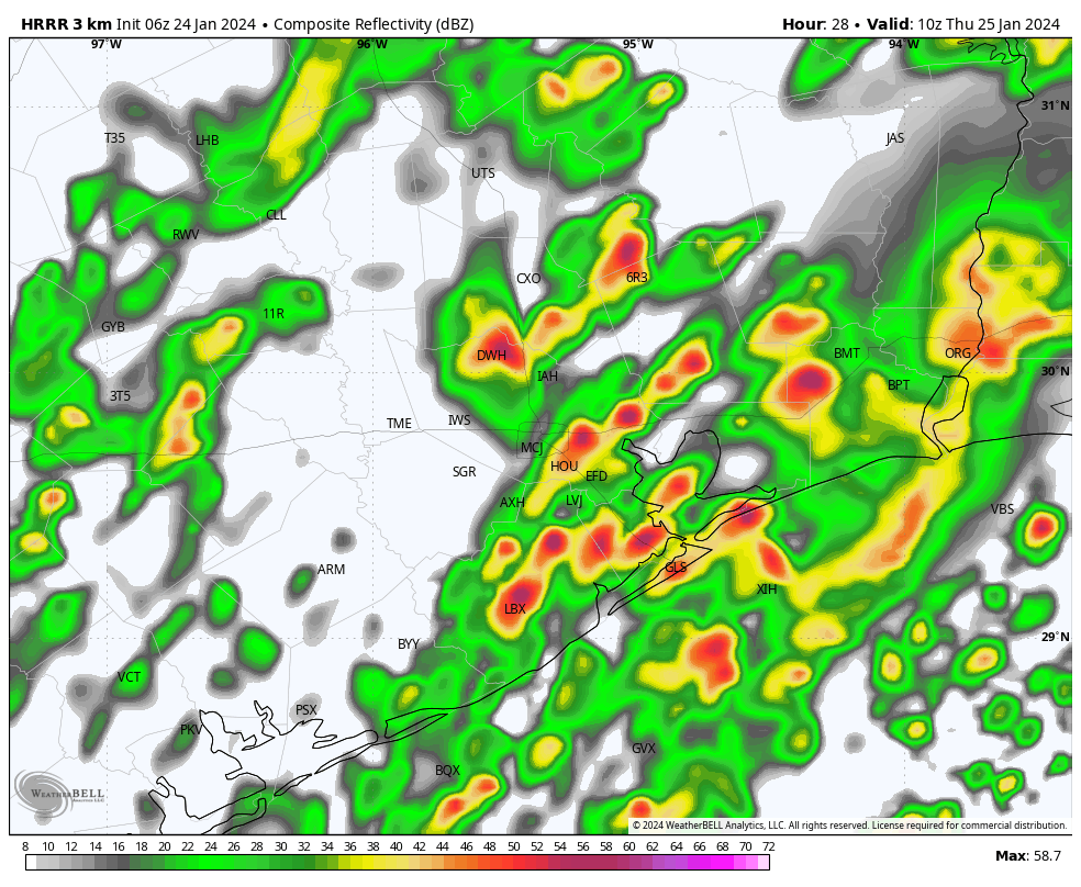
The radar shows at-times intense pulses of showers and thunderstorms moving from southwest to northeast across the southern half of the Houston metro area this morning in response to a passing disturbance. These storms have dropped 1 to 3 inches since midnight near the coast and will continue for much of the day. However there is some evidence that the storms should wane, somewhat, in intensity later this morning and during the afternoon hours. Accordingly, we can probably expect additional accumulations of 1 to 3 inches for areas south of Interstate 10. Rain is likely further inland today as well, but accumulations should be less with the focus near the coast.
In terms of impacts, as of 6 am CT, Houston Transtar is showing no significant problems on area freeways. In terms of area rivers and bayous, Jeff Lindner of Harris County Flood Control District said he expects to see some minor flooding today along the East and West Forks of the San Jacinto River. Other bayous, for now, look to be in good condition.
High temperatures today will reach the upper 60s, with cloudy skies. Winds will be light, generally from the northwest. The best time for a break in showers will come late this afternoon into the evening hours for the Houston area.
Thursday
I expect that an additional round of showers will develop to the west of Houston late on Wednesday night, and then push through the area from west to east overnight. These storms, perhaps producing another 0.5 to 1.0 inch of rain for some locations, will end as somewhat drier air moves in with a weak front. After lingering showers end during the morning hours on Thursday, we can probably expect partly sunny skies, with highs near 70 degrees. Lows on Thursday night will drop into the 50s.
Friday
This should be another day with highs in the upper 60s to 70 degrees. Skies will be mostly cloudy. We’ll see a decent chance of showers—it doesn’t look like anything impactful—later on Friday or Friday night as a stronger front pushes through Houston. This will set the stage for clearer and sunny weather.
Saturday and Sunday
The weekend will be sunny and chilly. Look for highs of about 60 degrees on both days. Saturday will be a bit breezy, with winds from the north, but Sunday should be fairly serene. Lows on both Saturday and Sunday nights will drop into the 40s in Houston, with upper 30s possible for areas further inland.
Next week
The first half of next week will see continued winter-like weather, with highs in the 60s and lows in the 40s. By mid-week we’ll start warming some, and some slight- to moderate rain chances return later next week and into the weekend to go along with mild temperatures.


Well, at least my yard is happy, lol.
Curious, did you talk to Jeff Lindner or did he merely post his opinion about East/West Fork San Jac? Because overnight, as usual, SJRA increased their release of Lake Conroe +1000 cfs about every hour, sitting at almost 12k cfs now. With the additional rain (and run off), they will continue to increase releases which will push San Jac past minor flooding. In fact West Fork is already above projection. It will get to moderate, possibly beyond depending on how much SJRA releases.
Thank you for the summary section at the top. I can read it in less than 5 seconds and know what I need to know for the day. Very helpful.
Thanks for giving us the data and not issuing a “red alert” day, deploying mobile units to show us what rainy streets look like, telling us not to drive over downed power lines (seriously?), or otherwise being our “weather nanny” today.
(Why I watch the weather on TV anymore, I don’t understand).
Personally, up in Spring I think we’ve seen WAY more rain than was called for. During every “break” we were supposed to get yesterday, it would be POURING outside! I’d check the weather apps and it would say cloudy or drizzle, so I’m curious if the actual rainfall totals are equal to what models are saying?
I’m in Klein and looking at the Harris County Flood Warning rain gauges, we’ve had 5 and 1/4 inches in the past 7 days (effectively since Monday) and it’s still raining.
Good (if very rainy!) morning to y’all!
We are aware of an issue with the SCW app that is causing new posts not to show up. Our developer is investigating and a fix should be in the works soon. If you did not update to the version that was release yesterday (1/23) then you should be seeing the latest posts. If you didn’t update, it’s best to hold off until the fixed version is available.
Thanks for your patience, and thanks for being a part of Space City Weather!
Thought Joseph would catch this. The other day I said we’re still behind on rainfall a lot just looking at the last 2 dry years. Decided I’d update my math for the Hobby station with the last 10 years to include Harvey. With that we ended 2023 only 2” under “normal rainfall” so all this rain is adding to the plus side at least based on the last 10 years. Bottom line: annual rainfall is quite variable here. (In case you didn’t know that) hahaha. Just looking out for Wayne’s water well – should be in good shape!
Lol yes indeed, rainfall is definitely highly variable year to year in our region. When it comes to annual temperatures and rainfall, there really is no “normal”. I’m sure you know this but for those of you that are not familiar, the average temperature and rainfall we go by is typically over the past 30 years of collected data averaged together. This is because there is always sharp variations that can happen each year so 30 years is the standard. No 2 years or seasons are ever the same. One year we can get 20 inches of rain and 60 inches the next year. That is why I enjoy the weather so much because there is a diffrent story to tell every year.
3 inches fell in just an hour in my backyard at causing some pretty high water in several locations. The water was shin deep in the back of my yard because the drainage ditch spilled way over the top. It has gone down alot now.
Well don’t sink in your backyard! Joseph is the best weather pattern expert for greater Houston that I’ve read. Many can say what’s coming for the next 5 days. Rare is the ability to put words into climate context.
Well thank you I appreciate that DJ. And I actually could sink in parts of my backyard now lol. Quiet a sharp contrast from the rock hard ground with 2 and 3 inch wide cracks I had just 4 short months ago.
The rain has stopped here (Westchase area) now (10:00AM). So far we have had 5 1/2″ since this all started Sunday.
It seems that most of the rain is north of I-10. At least the flood warning issued at 12:47PM by NWS is for northwestern parts of Harris County and for portions of counties north and west of that.