In brief: Although the coast has largely been spared heavy rainfall for the last two days, it now appears that the axis of strongest storms will shift there on Wednesday and Thursday. Due to this heightened threat for widespread street flooding, we are elevating coastal counties to a Stage 2 flood alert for now through Thursday evening.

Wary of offshore rains
As the Houston region has fallen into a very wet pattern over the last two days, the heaviest rains have fallen north of the city. Some locations in The Woodlands, for example, have received in excess of 9 inches of rainfall, and areas near Kingwood have received 4 to 6 inches. These heaviest rains have been fairly isolated, however, as most of the Houston region has picked up 1 to 2 inches so far.
We have a couple of more days during which the threat of heavy rainfall is high, so what will happen next? The majority of our modeling guidance suggests the threat will shift southward, particularly from southern Brazoria County up the coast through Galveston Island and all the way to Beaumont-Port Arthur. For this reason, we are elevating our flood alert for coastal counties to Stage 2 on our flood scale.
This means that for coastal counties—Brazoria, Galveston, Chambers, Jefferson, and Orange—there is the threat of flash flooding today, tonight, and on Thursday. Under Stage 2 conditions we generally expect widespread street flooding, and the potential for some localized flooding of homes and businesses. For the rest of the Houston metro area, and particularly areas along and inland of Interstate 10, lesser impacts are expected. We are maintaining a Stage 1 flood alert there.
Wednesday
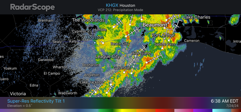
Just before sunrise this morning we are seeing moderate showers across much of the Houston area, and for now these are totally manageable. But there is a line of showers and thunderstorms just off the coast that is more menacing. There is a fairly good chance this line will slowly lift northward into the coast, including Galveston Island, this morning. This will pose a distinct threat to flood streets.
These showers will gradually spread inland today, but based on our latest modeling they should gradually have a reduced impact and weaken some as they do so. Due to widespread showers and mostly cloudy skies, we can expect highs today to top out in the the low- to mid-80s for most locations.
Wednesday night and Thursday
The most likely scenario is that we see a similar pattern tonight. Some time after midnight another line of showers and thunderstorms appears likely to congeal offshore and then push into Galveston, Chambers, and Jefferson counties during the wee hours. This may spark another round of flooding for areas along and near the coast through Thursday morning. These showers should move inland during the daytime, albeit with likely reduced intensity.
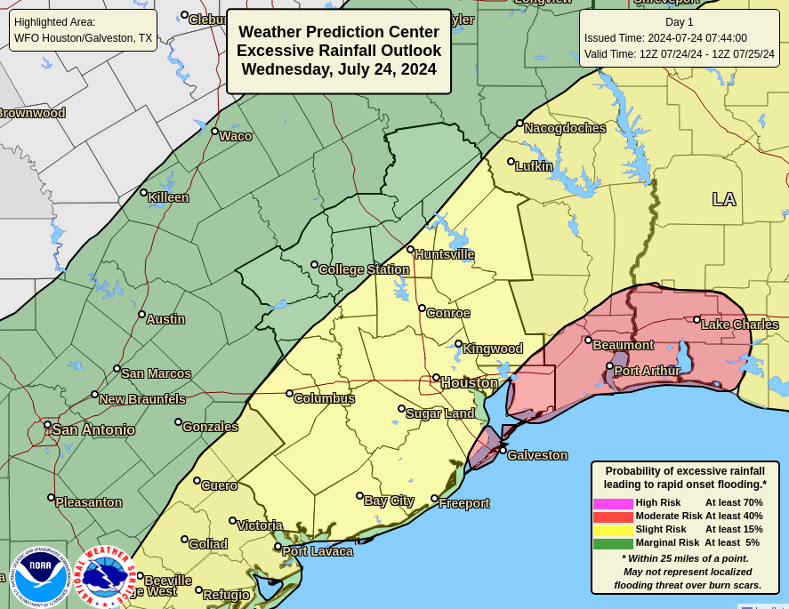
All told, most locations south of Interstate 10 should receive at least 2 to 6 inches of rainfall on Wednesday and Thursday. My concern, and the reason for a heightened flood scale alert, is the possibility for some of these storms to dump 10+ inches of rainfall right along the coast. The models are increasingly highlighting this threat for places such as Galveston Island and the Beaumont-Port Arthur area.
Friday, Saturday, and Sunday
The threat of very heavy rainfall should end by Thursday evening or so, but that does not mean our wet pattern will end. Rather, we’ll continue to see a healthy chance of showers through the weekend. We don’t expect to see the kinds of storms that will produce significant flooding, but there look to be fairly widespread showers. If you have outdoor activities planned, especially for Saturday, I would not feel great about them.
Highs for this period will range from the upper 80s to lower 90s, with partly to mostly cloudy skies. There is a chance of some sunshine by Sunday afternoon, however.
Next week
As high pressure starts to build into the area, next week should be hotter. Starting Monday, I expect we’ll reach at least the low-90s, and by midweek I expect Houston to be solidly in the mid-90s with lots of sunshine. We cannot rule out a stray shower here or there along the sea breeze, but these should not result in any serious accumulations.
We will have an addtional update later this afternoon or early evening to keep tabs on the situation.

Thank you for updating early.
We’ve hardly gotten anything at home or at the plant. but this should not be considered a mocking of the weather gods. I’ve learned not to do that.
Same here. Not one drop of rain on Monday, a few Tuesday and it’s Sunny this morning. Houston is great at Scattered Showers! Lol
Seriously! The NWS said the focus for heavy rainfall yesterday would shift to areas along and south of I-10. Instead, it remained north of Houston! We have gotten about 1/2 inch so far this week.
The scenario that gives my area less rainfall is usually the one that happens.
Yep, 600 square miles (and that’s just the city proper) will do that.
Galveston will be entirely underwater if they get 10 inches. Since the hurricane they haven’t cleaned the debris out of the drainage and it floods with just a little rain now.
In Orange County, and already had a good pour down this AM. But this is normal SETX weather.
Thanks as always for keeping us aware of the latest! You may not be able to answer this just yet but do you think Saturday night will be a wash out as well? We were planning on having an outdoor activity in the evening! 🙁
“ Friday, Saturday, and Sunday
The threat of very heavy rainfall should end by Thursday evening or so, but that does not mean our wet pattern will end. Rather, we’ll continue to see a healthy chance of showers through the weekend. We don’t expect to see the kinds of storms that will produce significant flooding, but there look to be fairly widespread showers. If you have outdoor activities planned, especially for Saturday, I would not feel great about them.” – per Space City Weather
Early morning, before dawn, we got a decent downpour here in Magnolia – for about an hour. Obviously, the storms have moved off to the east.
MSN’s future radar (up to 11:30am) shows light showers returning to the general Houston area. Likewise, Wunderground’s future radar (thru 2pm) also shows light showers returning general Houston area, and up here in the greater Magnolia area.
Guess we’ll run to HEB in a couple hours for our ‘food shopping every 3 days’ run 👍
Crazy rolling thunder last night, almost continuous booms, was crazy to listen to.
Are any of future casts worth a poop? Unless it’s a line of storms – which they’re pretty good at – their “look ahead” is most times pfffft..
Once again, looking at radar and nowcasting the rains and storms don’t have that ooph as they move inland. Good soaking moderate and at times heavy rain mixed in. Models are over doing it. Tomm could be different but we shall see.
In the Houston metro area July will likely finish both wetter and cooler than average. That’s a win in my book. It’s now only 63 days (give or take a week or two) until Fall Day 2024. The Texans are in training camp, school starts in about 3 weeks, St Arnold’s Oktoberfest will start showing up at your local grocery and the days are all growing shorter. All signs that the first cool autumn cool front is drawing nearer. Hang in there!
Back away slowly from the pumpkin spice…
Rain rain, go away.
Oh, come on, don’t be angry. There’s too much of that going on, and there looks to be a lot more difficulties ahead.
Someone needs a
hug
Yesterday Channel 13 was talking about a possible tropical depression moving inland with a similar track that Beryl took. I don’t guess that is on the table anymore I haven’t heard any mention of it again this morning. The bulk of the heavy rains have been largely offshore today.
Just got an update. There is a low pressure area that will move inland tomorrow but it is looking like it will shift further to the east leaving the Houston area on the dry west side. The bulk of the rains will hit the Galveston and East Texas areas now. There is still an off chance that the low could bring a ton of rain to the Houston area but it will depend on the exact track this low offshore takes.
You are using i.e. incorrectly, it should be e.g.