In brief: Today’s post goes into just how hot this week is going to get in Houston, and when we might expect a smidgen of relief. We also discuss the disastrous rains from Debby over the southeastern United States, and another tropical wave in the Caribbean Sea. Finally, if you’ve been noticing data issues on our app, we have an explanation.
A quick note on our app
If you opened our iOS or Android apps in the past couple of days, you may have noticed that weather data was missing. Issues with AccuWeather resulting in data ceasing to flow. We’re still working through the problem, but in the meantime, we’ve released a version of the app that reverts to using National Weather Service data. Make sure the devices where you’ve installed the app are set to auto-update and you should be good. Or, go to the respective app stores and manually download the latest version, which should appear today or tomorrow.
And it’s not just a bug fix: We’ve now made it easy to submit a bug report to us, which auto-populates with the technical details we need to chase down the issue. Tap/click the Settings gear icon in the drawer that shows all the cities and look for “Send Feedback.” Choose your email software at the screen that appears and an email with much of the needed info filled will be generated. Add as much detail about what you’re seeing and send it.
Thanks for your patience, and thanks for using the SCW app!
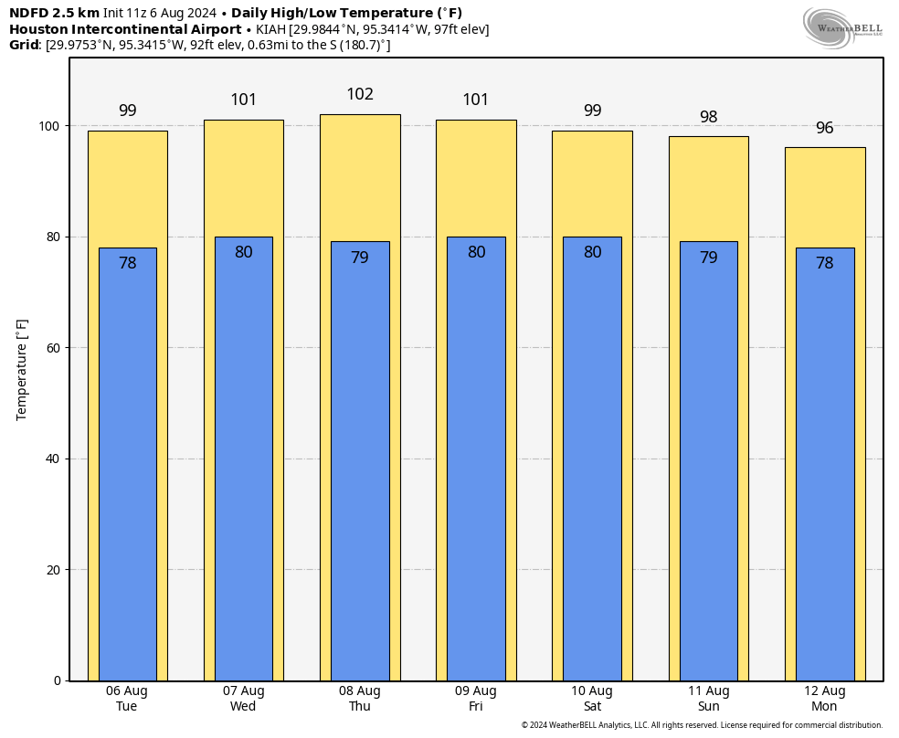
Tuesday
With high pressure firmly in control of our weather, today will be sunny and hot. High temperatures will push into the upper 90s for the majority of the Houston metro area, with a few inland locations possibly hitting 100 degrees. Do not expect much relief from a breeze, as winds will max out at about 5 mph. We may see a few clouds mix in this afternoon, but the chance of a shower is, at best, 10 percent. Low temperatures will fall only to about 80 degrees overnight.
Wednesday through Saturday
The heat will peak during this period, with high temperatures reaching around 100 degrees most days. Skies will be mostly sunny to completely sunny during this period, with clear, warm nights. Winds will remain low throughout the period. Rain chances are effectively zero. Houston in August, you’ve got to love it, right? Just kidding. I’m counting down the days until September (we have 26 left, by the way).
Sunday and next week
As high pressure backs off, we should see temperatures start to back off slightly on Sunday, perhaps into the mid- to upper-90s for most locations. It’s not much, but it’s something. We may also start to see some slightly better rain chances with some sea breeze showers starting Sunday or Monday. But we’re still looking at predominantly sunny skies, and any rain chances are likely on the order of 20 percent daily.
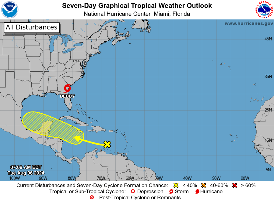
Tropics
Tropical Storm Debby is continuing to pound the coastal regions of Georgia and the Carolinas with heavy rainfall, and it’s likely to continue to do so for a couple more days as the storm essentially stalls offshore. This is already producing devastating flooding in locations such as Savannah and Georgia. We have more details about all of this on The Eyewall.
The National Hurricane Center also continues to track a tropical wave in the Caribbean Sea that is moving a little north of due west. There has been a hue and cry about this system on social media, as a handful of operational runs of the GFS model have brought a tropical system to Texas. While we cannot rule that out, there remains little support for such a scenario in the ensembles. The most likely outcome is a weak disturbance that continues to plow westward, remaining south of Texas. Regardless, we’ll keep an eye on things.

Funny! nothing much changes in Sept—it’s just as miserable as Aug!
Yea, but Sept 1 is like Wednesday…hump day! The end is in sight.
I learn so much from this site that isn’t weather related. Today I had to investigate “hue and cry” . How have I lived without this phrase thus far? Time to incorporate it into my daily conversations.
Beryl was supposed to stay to the south of us as well. There can be 99 models in a room and all it takes is 1. If it does make it to the gulf, surely the warm water will result in rapid intensification ?
Of course it will – too much fuel out there
So let’s prepare & hope the high pressure system tamps it down
All I can do to prepare is to listen to the weather reports, look at the models and such..To decide when to leave and where to go…Yes, I have non perishable hurricane snacks, and extra water at home for disasters..With that said, I cannot afford a home generator of any kind right now..We don’t ride out the hurricanes, if we get good info early enough..We’re older, and disabled, so we don’t do immediate hurricane aftermath…We cannot be daily searching/paying for gas to fuel the generator or ice to keep comfortable on hot days without electricity….So we rely on good and timely in formation to make our decisions on when/where to leave…We stay away two or three days, come back when cooling/food pick up centers are established and clean up had started…Has it gotten to the point, to stay prepared, that we have to keep perpetual early reservations made at hotels inland, to survive hurricane season?
I agree @Lisa … we find it’s easy (short drive) and inexpensive to go to and stay in BCS (Bryan / College Station) for a couple days.
If our home (Magnolia) security cameras don’t work, then no doubt the power is out at the house.
If everyone heeded the panic alarms from the media and rushed out of town, Bryan/College Station motels will fill up fast. Remember Harvey and the news channels set the ‘escape now’ button and I-10 was blocked with so many cars, no one could move. After that, TXDot then put in contraflow devices west of Katy on I-10 at enormous expense that have never been used. If another hurricane comes, best to be prepared to camp out in your house and shelter in place.
I’m replying to Ken, but I didn’t see a reply button under his text..
We don’t shelter in place if we can help it..Hubby uses medical equipment that needs electricity..His life does not depend on his bipap machine that he uses nightly, but consistent good sleep keeps him more well..
We also do not want to be days without AC in 90-100 degree heat..Pushing 70..Hubby got sick in the aftermath of Beryl, due to dehydration …He is a diabetic..I don’t think he drank enough to compensate for the fluid loss, that happened because of the constant sweating…
Lol, I cannot believe I’ve been here writing, on and off all day…Usually my days are pretty busy 🙂
I’m one of those who look at the models each morning ..I saw the handful of models play out where a system was coming to Texas, near Houston……All the focus, understandably on Debbie, there has been little info or expert interpretation of anything behind Debbie in the Atlantic, except for the hurricane center info……I’m not a weather guru…Suffering through Beryl has given me too much anxiety this year, I’m sure there’s plenty of us..
“Tropical disturbance with Beryl-like path starts brewing in Atlantic” is the new Chron headline, definitely going for the clicks today. That being said, if you haven’t restocked the hurricane supplies you used during Beryl, it would be a good idea to grab some more now, before everyone freaks our and over-buys. There is still a lot of hurricane season left, stay frosty and stay ready.
It is Beryl like…
Hate to say it but the app, even after I’ve deleted and re-downloaded, still is not working. Hope this gets fixed soon. Your site is my go to.
Centerpoint is stockpiling excuses and staging some rationalizations around the projected path of the next storm.
Can you cite examples? I’m not defending Centerpoint, just point me to where you read what you read..
There were deaths related to these prolonged power outages…Usually people who didn’t have the means to move around to safer places, due to lack of family/friends/mobility,ect…Centerpoint and our neglected infrastructure played a big part…
That wouldn’t surprise me at all. I expect nothing but incompetence and greed from them.
You mention Accuweather; I don’t have an extensive set of data but recent checks of radar images versus observed conditions by various organizations have indicated the images from Accuweather to be….well….inaccurate with, say, the KPRC/Channel 2 image being totally accurate. To that end, I suggest you take a harder look at Accuweather information with a determination on whether it is the most reliable source for you to post.
Howdy @Bill Killingsworth … I don’t rely on a single source of information, be it weather, etc. And especially for weather predictions. I refer to 4-5-6 sources of weather info.
One website I use showed the predicted path of Beryl to come right up thru the Houston area. That site was using “ICON + HRRR” for the prediction. It was the ONLY site that got it right.
Beryl made landfall on the 8th, that site showed the prediction on the 5th. I know, because I did a web search of the SCW site (moments ago) and see my two posts about the prediction.
Prominent folks in here responded (after Beryl) that the prediction was a luck of the draw (in my words), because ICON is unreliable. Guess what, it was more reliable than any other source (3 days before) that predicted a Mexico / Texas border to Corpus landing.
On the 5th, I warned my brother-in-law in Surfside they should vacate, and also warned my mother-in-law in Lake Jackson to make alternative plans. They did so and we’re glad they did. Heck, those of us up in Magnolia got a good hammering (plus 5 days without power / cellphone).
… Don’t rely on ONE weather source 👍
I don’t rely on one weather source..Yes, the ICON was correct with Beryl..
I could not justify spending money to flee Beryl(I live close to the water), just based on that one model alone..I need most of the models to agree on a narrow range of possibilities before I make decisions to leave dodge for a few days…With Beryl it was difficult to figure out where it was going…Our technology seems to be having trouble with this year’s storms..
Scare-u-weather and Bernie Rayno’s hyperbole are not for me. He & DeSilva pass scare around like a Punch & Judy show.
“There has been a hue and cry about this system on social media, as a handful of operational runs of the GFS model have brought a tropical system to Texas. While we cannot rule that out, there remains little support for such a scenario in the ensembles. The most likely outcome is a weak disturbance that continues to plow westward, remaining south of Texas. Regardless, we’ll keep an eye on things.“
Just the way that last weak disturbance blew westward into Mexico like you insisted it would over and over again until it came ashore directly south of Houston. Right.
I think weather people, especially these guys, are doing the best they can to keep us informed..I feel like our technology is having trouble with this year’s hurricanes, maybe an upgrade in technology is needed?
Yeah, I am a little worried by this new “disturbance.” Hurricane Barrel was supposed to go through North Mexico, and then it was coming between the border and Corpus, and then it was between Corpus and Victoria, and then at the last minute, they were like “hey it’s right outside your door.”
I am confident that Eric and Matt read and interpreted the Beryl models to the best of their formidable experience and available information, but I’d still really like the post mortem on where/how the models and data went wrong, especially so late in the forecast (less than two days before landfall). I know nothing is guaranteed and no one has a crystal ball, but what do the experts think happened there?
(Also hoping our high pressure keeps any pesky storms away this time!)
I’m not an expert but I think it just boils down to sudden quick changes in wind patterns. Hurricanes are steered by wind and pressure patterns and quick changes can happen that even the best forcast models can’t foresee. One subtle change in jet stream winds can completely alter the path of a hurricane.
With Beryl there was a firm high pressure ridge sitting over Texas. At first it looked like that high would remain mostly over Texas which would of steered it away into Mexico or Southern Texas. Instead the high weakened and split to the east and western United. Winds travel clockwise around high pressure systems so this gave a hole in Texas for Beryl to get pulled into. An upper level trough in the jet stream also dropped down into Texas as well and had it’s own pulling effect on Berly.
I don’t think there will ever be enough technology to ever predict hurricanes paths with precision accuracy. There are to many changes that can occur last minute with all of the steering current. That is why they have the cone of uncertainty. It is best to always be on the lookout if a storm is expected to be anywhere near your general region.
The cone of uncertainty is a good way to keep us informed…I know it’s impossible for humans to come up with precision forecasts…
Maybe I’m weirding out in my old age…
It seems in years past, that we lost a lot of the daily WIDE windshield wiper fluctuations of possible landfall locations once a storm developed enough to fly Hurricane Hunter aircraft /personnel into the storm and obtain data about storm location, wind speed, direction, ect..And these missions took place almost daily into developed storms? I wonder if they do still, once a storm has a formed center?
In the past, I believe at 3-4 days out, I had enough information to say either “Oh crap, I have to watch very closely, and begin to make plans to leave for a few days!” or “Whew, this probably isn’t our storm!”
You’re not weirding out. The models we rely on aren’t geared so well towards the extra heat the Earth is now experiencing.
Btw, ‘wide windshield wiper fluctuations’ is a good description 🙂
Good stuff, Joseph 🙂
Me too…
It seems that the models for the Florida storm were/are equally difficult to interpret..
And nobody wants to talk about more than one storm that’s brewing in the Atlantic anymore, except these guys…
The next seven day temperatures for Chicago are pegged at 67 – 71; it’s sort of insane to accept Houston’s weather as being so reasonable as to want to hang around here if you can afford to move.