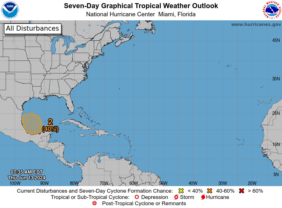
In brief: Houston will see a few more isolated to scattered showers and thunderstorms today, but overall our pattern will turn sunnier and a bit hotter through Saturday. After that the focus turns to the Gulf of Mexico, where a tropical disturbance is likely to develop. Local rain chances start to increase on Sunday, but at this point we expect the heaviest rain associated with this system to remain south of the Houston metro area.
Thursday
As high pressure expands over the Southern United States, we’ll see decreased rain chances today, perhaps on the order of 20 percent. Like in recent days, any showers and thunderstorms will develop during the late morning, afternoon, and early evening hours with daytime heating. A few areas may see accumulations of 1 inch or greater, but much of the area will see nothing. Skies, otherwise, should be partly to mostly sunny today with high temperatures in the low 90s. Winds will be light. Lows tonight will fall into the upper 70s for most locations.
Friday and Saturday
With high pressure reaching is broadest expanse into our area, skies will be mostly sunny on both of these days with temperatures in the low- to -mid-90s. Since we are very near to the summer solstice now, please know the Sun is almost directly overhead (an altitude of 84 degrees) during the midday hours. This will burn your skin quickly, so please take precautions. Afternoon dewpoints will be slightly lower on Friday and Saturday so it won’t feel as hot as it will later this summer. Rain chances on both days is 10 percent, or less.
Sunday and beyond
By Sunday our attention will turn toward the Gulf of Mexico. As we’ve been discussing for several days, a tropical disturbance is likely to form in the Bay of Campeche early next week. (The National Hurricane Center now gives the system a 40 percent chance of becoming a tropical depression or tropical storm during the next seven days).
At this point I am fairly confident that high pressure over the southern United States will help to keep this system penned up in the southern Gulf of Mexico, and eventually steer it westward into Mexico (most likely) or South Texas. Although some organization is possible, the main threat from this tropical system is very likely to be heavy rainfall.
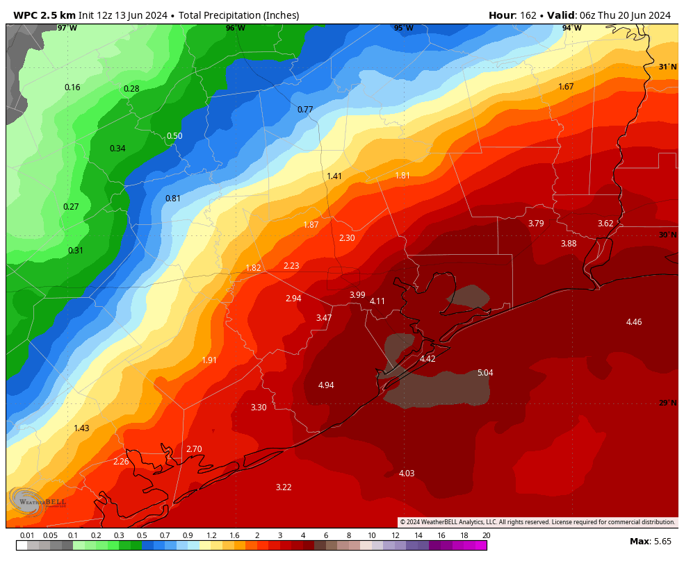
Due to the overall steering that we’re expecting, I think rainfall accumulations for the Houston area next week are likely to be manageable. Totals are likely to be highest along the coast, with the potential for 3 to 5 inches, with lesser amounts likely for inland areas. Greater accumulations than this are possible for locations further south, such as the Brownsville area, but uncertainty remains.
In the greater Houston area we’re also likely to see stronger onshore winds, perhaps 10 to 20 mph, with higher gusts, associated with the system. Tides may also run 1 to 2 feet higher with a persistent onshore wind. All of this forecast is subject to change if the tropical system evolves differently, but as for now I anticipate our localized effects to be mostly modest.
The bottom line is that much of next week, beginning Sunday, is likely to bring at least partly cloudy skies into the region with the chance for intermittent heavy rainfall. This pattern should help to keep high temperatures in the vicinity of 90 degrees, so a bit cooler than normal. Matt and I will be watching this closely and update as warranted if the forecast substantially changes.

Should Katy evacuate?
Yes
Wen evacuate
Wen Moon
Always stupid as usual. At least the responses have been stupid, too. Glad to get this one out of the way so early in the season. Focus on the real stuff now.
It isn’t over, it’s just beginning! Prepare now!
To quote the great philosopher Chris Berman, “There’s no such thing as a stupid question, only stupid people.”
So different opinion to yours = stupid. Pretty lame way to live imo. Why concern yourself with others at all if you can’t handle it?
That statement sums up the stupidity of climate change deniers. Others opinions don’t override facts.
Hopefully, the “thing” (movie reference meant) that the GFS is brewing for us on the 26th is one of those “scare-i-canes”. Fortunately, the Euro model shows nothing.
The GFS has pushed out some concerning models these past few days. The model for the 26th is showing a near miss and us staying on the “clean side” of this.
Models that far out in time are not always 100 percent accurate and will change. why bring it up now?
Yeah, the one early this morning was from a Cat 3!
Exactly
Matt addressed this in a post on The Eyewall earlier this week. The GFS model has a tendency to overdo it on forecasted tropical systems in the Gulf this time of year, and it seems to be an outlier on this one.
He did, but both models were trending together & it’s harder to dismiss both
I’ll take the manageable rain along with slightly cooler temperatures, just hope it holds true and doesn’t go further south or develops, cause then we’ll get practically nothing. There are also parts of the state that could really benefit from it.
I’m in agreement with you. But, I wouldn’t mind it dousing Mexico and any remaining agricultural fires to keep that smoke from wafting up here (like from a few weeks back).
If it soaks other parts of our state (West Texas, I’m looking at you), that could work, too. We’re a bit soggy here so cloudy but dry is good.
Yikes, AirBnB rented in S Padre Sun – Sat next week.
Apple App Store says Space City Weather app is no longer available. ??
Just as easy to view the website with a browser. We tried the app (Android), but offered no advantage for us.
Interestingly the GFS model is showing 15″+ rain just east of here at the end of its 72 hour run. Something to keep an eye on.
I fully expect that precipitation forcast to drop more and more as we get closer to next week.
SOUNDS LIKE SURFS UP BRAH!
We haven’t had a bad wind hurricane since Ike in 2008. I have a bad feeling about this year. Perhaps by announcing it publicly, I will give us the “reverse hex” and we will get nothing, I hope.
For those worrying about the GFS’s “Modelcane” on the 26th? Outside of 10 days the GFS has forecasted 27 of the last 1 storms to actually materialize that far out…
💗
“In brief: Houston will see a few more isolated to scattered showers and thunderstorms today …”
Today? When? 🙂
I’m with Drought Hater: This will be another “much ado about nothing” storm. The storms they can’t seem to predict are the ones doing the most damage, not the ones that get talked about, hyped and then nothing happens. Houston will likely see nothing out of this one but cooler temps will be nice.