In brief: The much-discussed Arctic front is on schedule for this afternoon, bringing freezing temperatures to the Houston area after midnight tonight. This post discusses how cold we’re going to get, and whether precipitation on Thursday will just be rain, or something else.
Cold coming
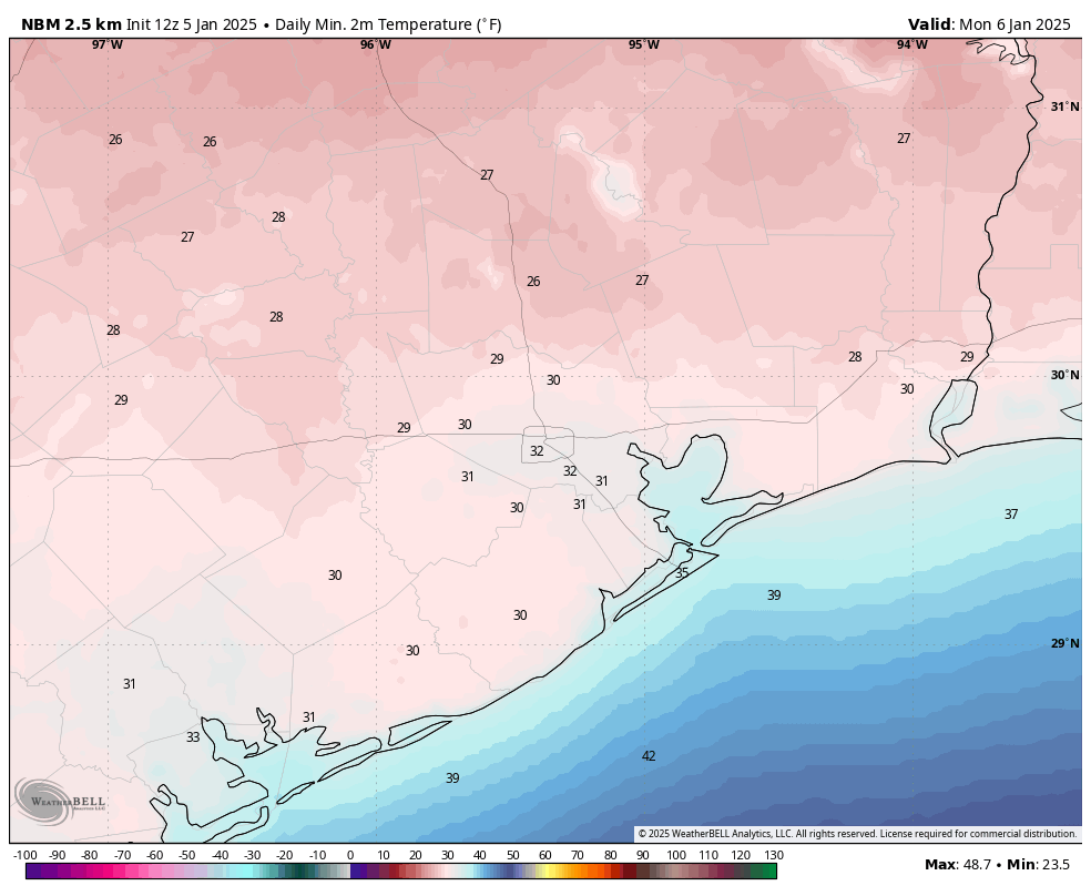
The first few days of the new year have been relatively mild, with high temperatures in 60s and 70s. That will change in a big way later today, with the strongest front of the winter season on track to arrive in the Houston area this afternoon. This front will usher in a freeze to inland areas, including locations such as Katy and The Woodlands, by around midnight. Temperatures should reach freezing for all but areas immediately along the coast by Monday morning. Colder than normal weather will stick around for the remainder of the week.

Frontal passage
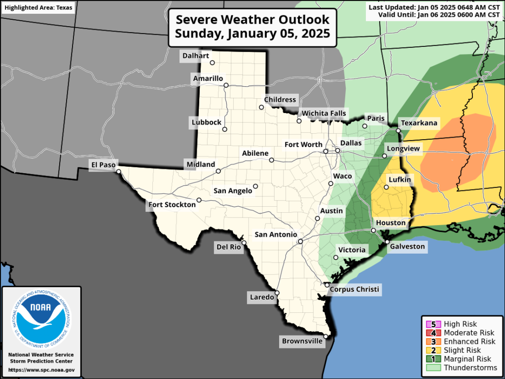
Some showers and possibly a few thunderstorms will accompany the front’s passage today as it moves from northwest to southeast across Houston. At present I expect it to reach northwest Harris County by around 2 to 4 pm, and swoop down to the coast by around sunrise. There is a slight chance of some severe weather with the front, especially to the northeast of Houston, in the form of stronger thunderstorms. But mostly, everyone will notice the winds kicking up, and drier air moving in. Temperatures fall pretty quickly behind the front.

Monday, Tuesday, and Wednesday
This will be the coldest period, with daytime high temperatures in the 40s. Each night will bring freezing, or near-freezing temperatures throughout Houston. It’s possible that the urban heat island effect could keep some parts central Houston at or just above freezing. But the bottom line is that if you have tender plants, and do not live right on the coast, they are susceptible to freezing.
However, most of the Houston metro area will not face a hard freeze. That is when air temperatures fall into the mid-20s or below, at which point one needs to worry about pipes. So from an infrastructure standpoint, I’m not too concerned about this freeze. A hard freeze is possible for areas along and north of Highway 105.

A wintry mix on Wednesday night?
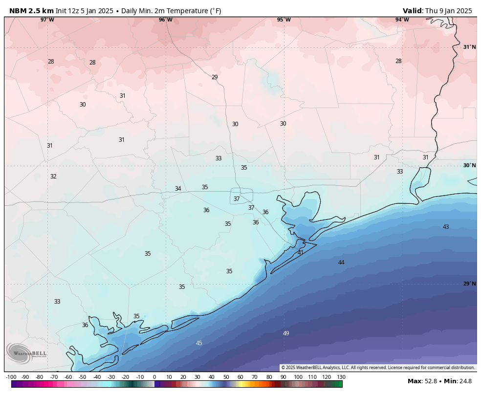
There is still some uncertainty about conditions on Wednesday night into Thursday morning. A low-pressure system is likely to being a healthy chance of rain into the forecast late Wednesday night and into Thursday. Overall we may see as much as 1 inch of rainfall. The question is whether temperatures are cold enough on Thursday morning to support a wintry mix, be it snow, sleet, freezing rain, or what have you. Another factor is when the precipitation starts, as by mid-morning temperatures should be comfortably above freezing.
My sense is that most of Houston probably will just see rain, but that areas inland of Interstate 10 have a chance of seeing snow or sleet. I think it’s a low chance at this point, maybe 10 or 20 percent. But it’s something we’ll keep an eye on considering the potential for mischief with transportation on Thursday morning.

Once all our season preventative winterization is complete, this is what we property managers rely on to determine when we go into full on winter mode. Thank you for the Sunday post and the great information. You help keep our communities safe and functioning.
I live in Angleton, do I need to wrap pipes and keep a steady drip inside?
Idk but I decided to go ahead and wrap my pipes even though I am not in hard freeze predicted area. Predictions are just that and I’d rather wrap them for nothing than have them burst if the Forcast is off. Just something to consider especially if you can’t afford costly repairs
We wrapped our outside pipes and I’ll keep our cabinets open below the faucets with a bit of drip once 32 degrees hits. Hoping power stays on so heat will keep everything inside toasty! We’re in the Katy area. 👍🏻
Dripping your faucets lowers your & neighbors water pressure and does NOT protect your plumbing system.. Keeping cabinets below sinks ,etc may prevent freezing pipes.
Probably not. Temperatures are not expected to drop down to 25 or below across Matagorda or Brazoria County.
I would wrap them just in case….. and if it does freeze, you don’t want to be out in it, wrapping them in the middle of all that cold.
Thank you for keeping us informed.
So, sounds like lack of precipitation will keep roads (I-45 / N Fwy up-to and North of the Houston Metro area) clear sunday night through sunshine on Monday?
So glad & grateful to see your post – ty for the information 💗
Does anyone predict there being ice on the roads tomorrow morning? Mostly trying to plan my commute to work.
Allison: my only concern for tomorrow morning and Thursday/Friday, especially during the overnight and early morning periods, is the possibility of ice on the bridges.
Thank you!
Thanks for the Sunday post Eric!
Does 20 miles inland qualify for “immediately along the coast”. Asking for a friend.
I live in Macgomery county Splendora Texas. I keep seeing that we are supposed to get a Wintory freeze mix in the next day. It says no back-and-forth back-and-forth. What is your forecast? I have many animals.
Bring them inside or provide warm shelter for your animals- better to be safe than sorry
We live in Nassau Bay across from the Space center and are unsure if we need to bring in our plants. What do you recommend ?
Should I cover all my outside plants, shrubs and flowers if it’s only gonna be in the 30’s?
My question too. I have a lot of succulents on patio also ivy in hanging baskets and a large ficus tree. 🤷🏻♀️I read “not a hard freeze” so I’m thinking plants will be okay.
I brought my ficus in, but it’s potted, so 🧐 I also brought in the succs and everything else is going to have to deal with the nature of Darwinism lol.
My sprinklers are on right now (2.00 PM) trying to drive the roots of all plants down lower hoping to miss the freezing air. I’m glad to see it will not be a ‘hard’ freeze – yet. I may cover the pots with freeze cloth to keep the air off them to night. All my pollinators are in full bloom, which is problematic. I’m hoping they will not suffer with a prolonged freeze – even if a light one.
I’m rootin’ for your plants, KenJ!
🌱☺️🌱