In brief: Spring effectively ended on Monday after two lovely weekends in a row. But that’s all over now as summer has arrived in Houston. Expect hot and sunny weather to prevail for at least the next week, and probably beyond.
An almost summer-like setup
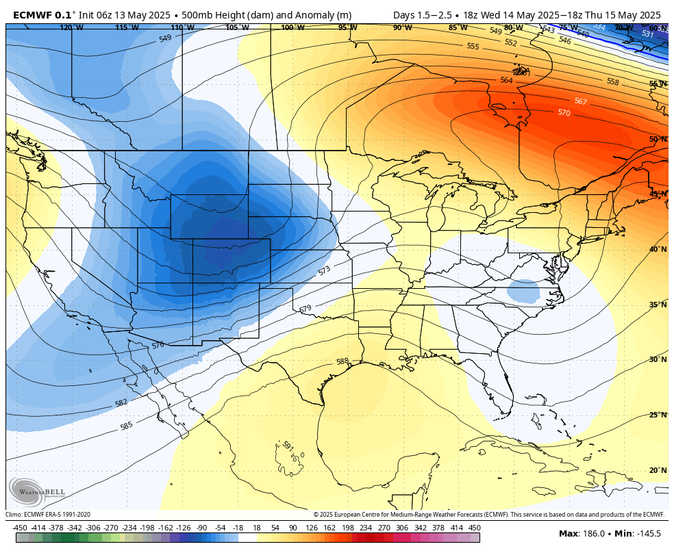
High pressure has begun to build over the region, and this will continue to intensify over the next few days. This means sinking (rather than rising) air, and mostly sunny days. In addition to this we are seeing a southwesterly flow in the atmosphere, bringing warm air into the region. This is a classic setup for hot temperatures, and although it is just May this is the pattern we are going to experience for at least the next week, if not beyond. In my opinion the 90s was an excellent decade, I would argue the best decade, but I’m not sure its the temperatures I want to feel in May. But here we are.
Tuesday
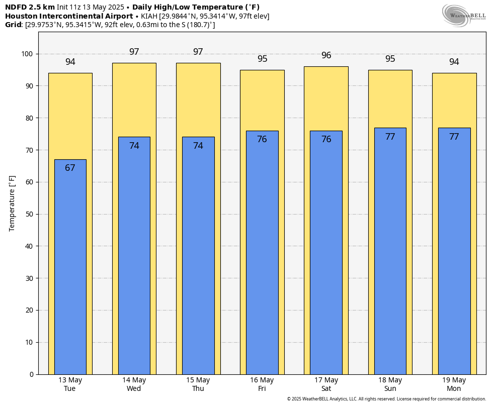
As a result of this pattern we can expect mostly sunny skies today, with high temperatures in the low- to mid-90s across the city (the coast may be slightly cooler). Southerly winds will be gusty this afternoon, up to 20 or possibly even 25 mph. And we can more or less expect the same southerly winds, peaking during the afternoon, for the next week. Low temperatures tonight will unlikely fall much below 75 degrees. Oh, and there will be humidity. Plenty of it. Rain chances are near zero.
Wednesday through Sunday
The above pattern will more or less persist through the weekend. I think temperatures will peak on Wednesday, with many locations possibly reaching the upper 90s, but we should come down a couple of degrees by the weekend. But this is splitting hairs, really, We are looking at sunny and hot weather during the daytime, and partly cloudy and muggy nights. If you’re heading to central Texas, the heat will be scorching there. Austin is expected to smash daily high temperature records by as much as 10 degrees, with a high approaching 107 degrees on Wednesday.
Next week
At this time I don’t expect much change at least for the first half of next week. Highs will likely remain in the 90s. We may start to see some spotty showers as the upper air pattern changes a bit, but once we get into these hot and rain-free patterns, long-time residents will know they can become difficult to break.

I agree the 90s was the best decade especially for movies tv shows and music 🤟🤟
Looks like we’re going to settle into 5 months of boring forecasts of 90s/100s, humidity, maybe some rain, with the occasional hurricane scare. Light work!
Its like that every year, what were your expecting?
I remember back in the day May was warm and humid but not August like. Most days were in the mid 80s with most nights in the 60s. This upper 90s with lows near 80 garbage in mid May is not normal at all. Even June was fairly moderate back then with most days in the upper 80s. We didn’t used to start seeing weather like what we are fixing to get until like Mid July through mid August.
Yep, me too. If it was 90 in May it was very unusual. It’s getting hotter here, no matter what the climate deniers say.
I used to have a good rule of thumb for Central Texas: April meant highs in the 70s, May meant highs in the 80s, June meant highs in the 90s, then after that good luck. That rule of thumb is long gone now.
These record shattering heat waves we keep getting through every season of the year now are getting real old fast.
AGREED
The last few days were so nice, now I check the 10 day and whoa!! I feel like last several years we usually go through an early summer high pressure heat wave with almost no rain for 3-4 weeks before settling into “normal”summer conditions until August. Not sure if that’s coming but at least the current drought level is None for half the state.
Wow 107 in Austin and it’s only mid May but the deniers will continue to say that this is normal and the climate isn’t getting hotter. 🤦♂️
Today’s record high of 94F (what today’s temp was) was set in 1907.
“So it begins”. – King Theoden from the Lord of the Rings.
Which is exactly how I feel about battling this summer.
Better than last May 16th 🌻
Agreed
Harris County had the highest population growth in the USA with over 105,000 new residents in 2023-2024. That is a lot of heat generating humans moving here despite how bad things are supposed to be.
So, you’re saying that the massive urban sprawl, with concrete, asphalt, dark roofs, lack of undeveloped natural areas for heat sinks, makes the city a heat island on sunny, high pressure summer days?
Next you’ll tell me that water is wet.
It’s much hotter than normal in areas outside of the city as well genius.
https://www.climate.gov/media/11332 …. has a graph to show the temperature of earth over millions of years.
Highest population growth in the US?? Why would anyone move here?
Jobs and opportunity. A/C made this place livable.
The ONLY reason anyone would move to Houston is a job. There is nothing remotely appealing about this city anymore, and I was born and raised here.
Less than 3 weeks until Hurricane season! Let the prep commence!
When can we expect our first fall cool front, on average, the date? Give us something to look forward to. Lol
Fall officially starts September 22nd, we should get some decent cold fronts in October. See you in 5 months.
It must feel really good to powwow in the comments with all of the other climate change activists. Every report gives more fodder to laugh at the climate deniers from your throne of historically recent, politically charged data. I’m sure all of you ‘keepers of the truth’ are running your AC at 85 and riding a bicycles everywhere to do your part. Surely you’re not living in total hypocrisy while virtue signaling to whoever will listen. As a proud ‘denier’, I am impressed by your dedication to the climate religion. Keep praying for more taxes that will be distributed wisely to government cronies with zero accountability and will surely help bring down the temperatures. Carry on. . .
What would you do if you believed it was completely true and that the worst case scenarios were reasonably likely?
Would you even then be able to ride your bike everywhere if your job was a 30 minute drive away from your house? Our city is probably the worst designed city in the UD, in terms of destructiveness to community and to the environment. Just because we can’t live sustainably doesn’t mean we are hypocrites.
I wouldn’t even bother trying to reason with people like that. When it gets to the point where we are literally having daily highs above 110 for 3 months in a row, the same trolls will still deny what is going on and use the same talking points like, “It’s summer, bro,” or “The Earth’s climate has changed before, bruh.” There is literally no reasoning with these people lol
If you believed your worst case scenario was truly possible/likely, wouldn’t you move to a place where you could live sustainably? Do you believe it? Or is it just a cause that gives you a perceived moral high ground and feels good?
Me riding my bike to work, and turning my AC off will not change anything. What actual climate activists are advocating for is the systematic transition to clean, renewable energy sources to escape the heat-trapping gases that fossil fuels create. No, it will not be an easy or overnight process, but something will have to be done soon, or the consequences in the near future will be pretty dire. The evidence is beyond overwhelming that our CO2 emissions are heating things up rapidly. The planet is warming at such a fast rate that many places will be unlivable by 2050 if not sooner. And I would say that with parts of Texas already reaching 107 in mid-May, we are already quickly approaching uninhabitability here at home. And no, I do not agree with blocking traffic to send this message. I am not one of them.
Is there an explanation as to why Galveston appears to be missing out on this heatwave? Looks like all week they will have highs in the mid 80s
It’s May, so the Gulf isn’t boiling yet, and there will be a strong southerly wind off the Gulf this week.
Such a miserable city to live in. Sadly I am stuck here caring for elderly parents but dream of the day I can get out of this grossly overcrowded, hot, humid, dirty city with zero quality of life, nothing but apartments, $1M tract homes, horrible roads, traffic 22 hours a day, paper plates on half the cars, and record levels of uninsured drivers that we all pay for, but “jobs”!
Agreeing. Grew up here, left. Back for work. It’s beyond a misery. Jobs & family obligations are the only reasons anyone would come here/stay here.
I (still) do love the HMNS & I loved the Ren Fest before it became a hot mess.
I’m just trying to find something I like/love & keep focused to that. But damn it’s hard.