We managed 99 degrees officially again on Monday in Houston, but you may have noticed at least a little less humidity around that peak heating. It’s not much but it does help. So does air conditioning. Your author got his back before Monday afternoon, so we’ll call that a win.
Anyway, the hot weather will continue and so will the dust.
Today
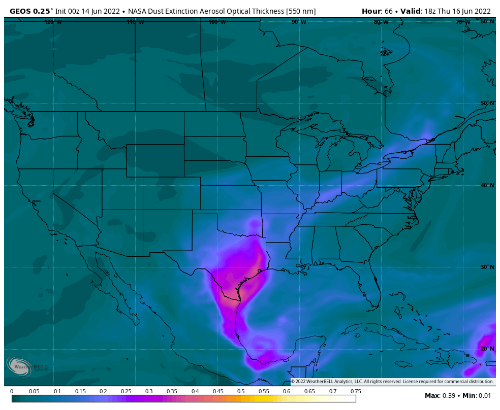
Look for another day with clouds, haze, and sun. We should be able to shave a degree or two off yesterday’s 99 degrees, so look for something more in the mid to upper-90s. Another burst of Saharan dust arriving today should help us double down on the hazy conditions and poor air quality. If you are asthmatic or are sensitive to poor air quality, it would be a good idea to limit outdoor time as much as possible the next few days.
Wednesday through Friday
Of the next few days, only Friday carries something above a 10 percent chance of a shower. Look for sun, clouds, and continued Saharan dust, likely at its worst on Thursday.

High temperatures will continue in the mid to upper-90s, with lows in the 70s and 80s. Those Friday rain chances stand at around 20 percent, so a few locations could see a welcome shower or downpour but most will not.
The Saharan dust event should end on Friday, with better air quality and less haze for the upcoming weekend.
Weekend into next week
More of the same. The weak backdoor cold front (a front that comes out of the northeast…from Louisiana) that we were looking at on Sunday looks to get held up to our east. Truthfully, I just don’t see anything better than 20 percent rain chances on any given day into the middle of next week. Highs will be well into the 90s each day.
Tropics
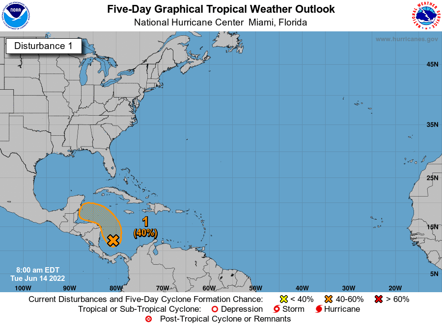
The National Hurricane Center continues to outline this area in the Caribbean for a chance at development over the next 5 days.
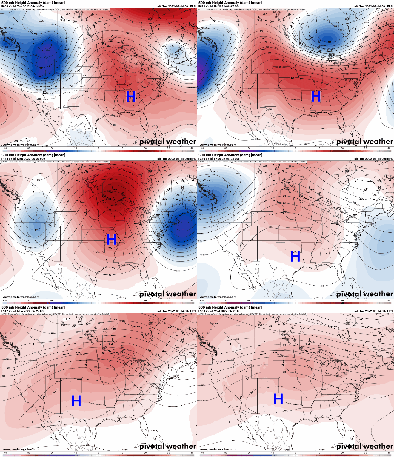
This is not a concern for Texas, and it’s rather easy to explain why. Our weather pattern over the next week (and beyond) will continue to be dominated by this fluctuating ridge of high pressure in the upper atmosphere over the Central U.S. As this system waxes, wanes, waxes, and moves around, one thing stays true: It stays in a position to basically shield Texas from any tropical nonsense right now.

This is both good and bad. It’s good because we could use a year off from hurricane risks. It’s bad, however, because it is likely going to cause the drought across much of Texas to expand and intensify. We could use a little surge of tropical moisture for a couple days. It appears we’re not going to line things up correctly.
Will this heat ever end?
This brings me to the last point today: Many of you are asking when this abnormally hot weather will end. Texas is always hot in summer, but we’re running consistently above average right now, more like July than June. The honest answer is that I have absolutely no idea when this will end.
We’re getting ourselves into a bit of a pickle right now, with a stubborn weather pattern that keeps reinforcing itself over the Plains. Just look at that loop above and you’ll see this. There’s a saying in meteorology that “drought begets drought,” as patterns can occasionally start acting on feedback loops. More dry air, more dry soil, more dry air, more heat, more dry air, etc. I see absolutely nothing right now that would act as a catalyst for change, so we may be stuck in this morass for the rest of June at least, if not longer. We’ve been telegraphing this for a couple months now, but prepare to hear more about drought, burn bans, and maybe more in the weeks ahead. Things can always change, of course, but we’ve got little data to predict change right now.

It sucks now, but I’d be grateful for a high-pressure ridge in August or September to shove away hurricanes during the worst of the season.
Great report this morning. The pressure map over the next two weeks was very interesting. That sure is a stubborn High over the plains.
Short answer. The heat will finally end in late October to November if we are lucky 🤞
I’m going to echo that the 2-week high-pressure animation loop was informative!
While I appreciate the H’s shielding effect, I wish it would move into the central Gulf so that it would shield us and allow for some cooler circulation from the north (maybe). But, maybe it is taking its time until August to meander that way to really be useful.
Meanwhile, June is halfway done and we’re that much closer to technical autumn.
Nooo. I don’t want autumn, i want the usual spring storms.
The last summer I remember a similar pattern of drought, it finally ended when Hurricane Ike came to town. I’m wondering if this will end up repeating this year. That summer, we had no rain and over 100 degrees for 30+ days in a row. It was brutal and that was 2008?
That actually sounds a lot closer to the summer of 2011, in which every day in August except one reached 100 degrees officially. There were no hurricanes that year for us for what it’s worth. I think I remember the summer of 2008 being fairly normal.
you are thinking of the summer of 2011, when there was no hurricane or tropical storm.
The burning truth. As in 1998, 2009, and 2011.
The Death Ridge is a Hurricane shield, but is also a rain shield. Worse case, no regular rains until October.
I’d rather chance the tropical weather than deal with this heat. Hurricane chances are always relatively low but this heat is the worst!!
I wish the winds would finally slow down.
I recall seeing a special on the value of Saharan dust in providing minerals and nutrients to the Amazon area – we can hope that the dust that comes to Texas is equally beneficial.
And yet rains (flooding in New Orleans) and lower Temps in Louisiana…we are blocked by the high pressure, feels like 2011.
This weather is depressing and enervating. Heat is expected, but broken up by some tropical rains once in a while. I remember summer 2011 and it sucked.