In brief: Houston’s late summer heat will continue this week, but a modest front should bring some drier air by Thursday or Friday. We have a chance of a stronger front in a little more than 10 days, but no promises. We also have details about our special Fall Day celebration I’m excited to share.
Fall Day
Admittedly the next few days will not feel much like fall in Houston. But that has not stopped us from preparing for Fall Day, and we want to invite everyone to come out and partake in the festivities on Saturday, October 25th. This year’s gathering is extra special as we will be celebrating the 10th anniversary of the site!

Here are some of the great things we have planned:
- Meet and greet with Space City Weather team
- Free tote bag giveaway to first 100 visitors
- Chalk wall for guests to share their favorite Houston weather memory
- Free face painting
- Exclusive sale of 10th anniversary t-shirts (see logo above), not available at any other time
- Lawn games
- Art activities for kids
- Coffee and snacks available for purchase
- Reliant tent with giveaways
- Free 360 photo booth
Fall Day is simply a gathering to celebrate the end of summer in Houston—to enjoy the outdoors and look ahead to cooler days. This year we have reserved the entirety of Midtown Park, 2811 Travis, in Houston. The event will be held from 10 am to Noon. If you can let us know you’re coming by signing up here, it would be great for planning purposes. But it’s not essential. See you there!
Monday
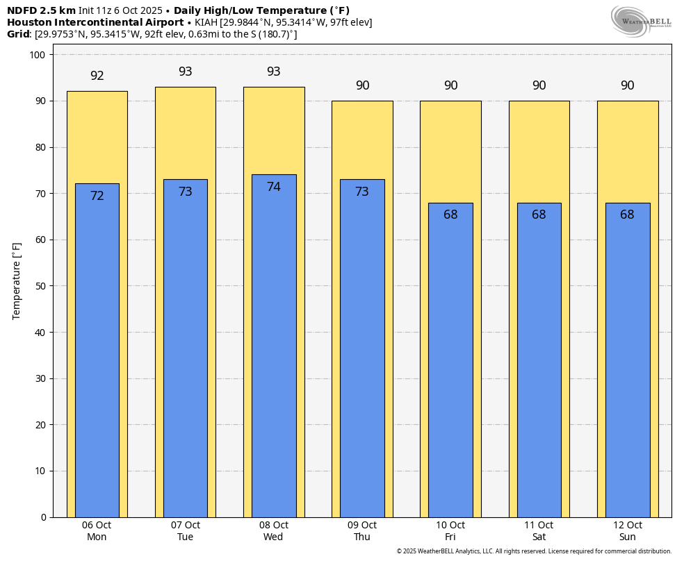
Our late summer-like weather will continue for much of this week before some kind of front, probably fairly weak, arrives by Thursday or Friday. Until such time our weather will largely be driven by high pressure. For today that means high temperatures of about 90 degrees in the city of Houston, with higher temperatures to the west and north of the city. Winds will be light, generally from the east to northeast. Skies will be mostly sunny. Overnight lows will be sultry. Dewpoints of around 70 degrees will be sticky, especially for October.
Tuesday and Wednesday
These will be the warmest days of the week, with high temperatures likely in the lower 90s in Houston, with the possibility of mid-90s for far inland areas. I don’t think we will quite get to record highs in Houston (95 degrees on Tuesday, and 96 on Wednesday, but we’re going to get close). Rain chances will be low, perhaps 20 percent each day along the sea breeze. This doesn’t look like much, but it may offer our region’s best chance of rain for the next 10 days.
Thursday and Friday
By Thursday or some drier are should start to work its way into Houston. This probably will lead to high temperatures of around 90 degrees, with lows in the upper 60s. Sunny skies prevail.
Saturday and Sunday
Expect more of the same for the weekend, with sunny skies and highs of around 90 degrees. Dewpoints look to be a bit lower, in the 60s. So while it will be warm, it won’t feel like full-on summer. Rain chances remain low to non-existent.
Next week
The headline of this weather update promised “hints” of cooler weather. We are going to get some of that this weekend with a weak front. Well, most of next week should bring continued highs of around 90 degrees. However, toward the end of next week I do think we have a decent chance of seeing a stronger front. I’m not ready to write this in ink for a variety of reasons, such as it being 10 to 12 days out, and our late summer heat has been pretty persistent. But I do think fall has a pretty OK chance of breaking out late next week.
