In brief: Today’s post discusses how this time of year is normally when the Atlantic tropics really start popping off. Also, Houston is going to see a very hot and mostly sunny week, which is fairly typical for mid-August.
Hurricane season snapshot
This has already been a very active Atlantic hurricane season. Although there have been just four named storms so far, two of them have become hurricanes, Beryl and Debby. Beryl is the most notable storm so far, reaching Category 5 intensity two weeks earlier in the Atlantic season than any previous storm on record. It also struck the greater Houston area, of course, causing widespread power outages and significant tree damage.
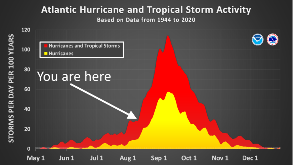
However, the reality is that during a typical hurricane season, about 90 percent of activity (as measured by the duration and intensity of tropical systems) comes after August 10. This can be seen in the image above, which shows the number of active storms, by day, across the previous eight decades. Historically we really start to see activity take off at this time, and remain very high for the next couple of months.
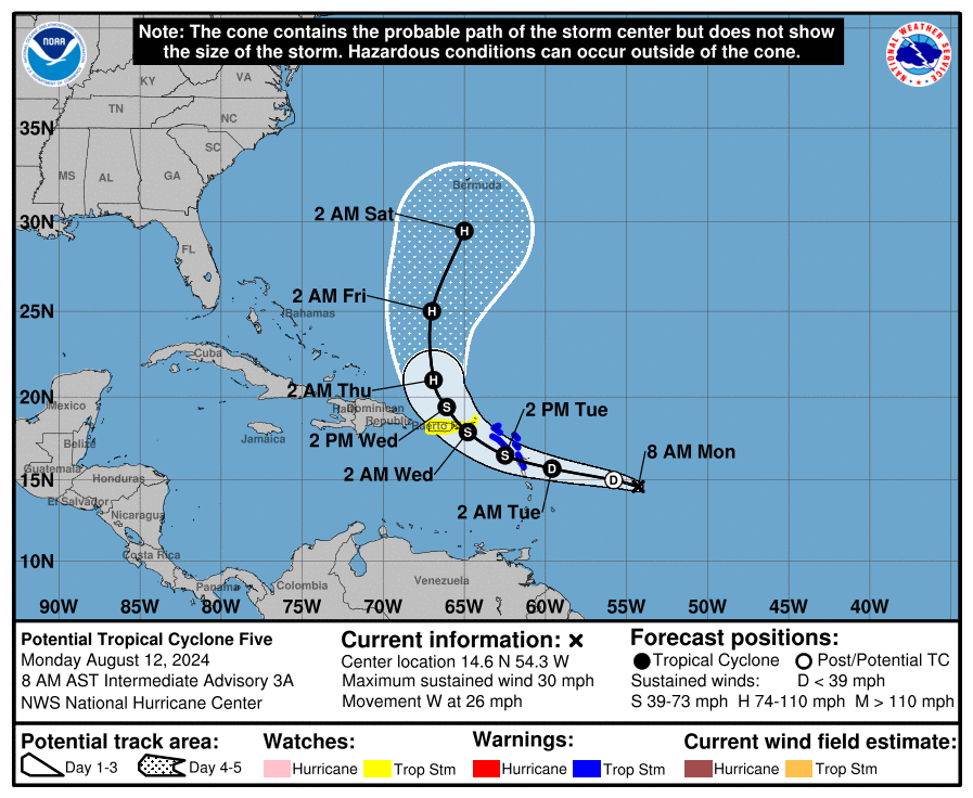
And right on cue we have Tropical Depression Five in the Atlantic Ocean. This storm is definitely not a concern for the Gulf of Mexico, but could threaten Caribbean Islands such as Puerto Rico before turning north and possibly striking Bermuda. The good news from our perspective in Texas is that after this storm—which would be named Ernesto—the Atlantic tropics could quiet back down for a short while. Looking at available model data, we’re not yet seeing evidence for a flurry of storms through mid-August, although that certainly could change by the final week of August.
August countdown
Speaking of August, my choice for the worst month of the year in Houston, there are 20 days left until the beginning of September.
Monday
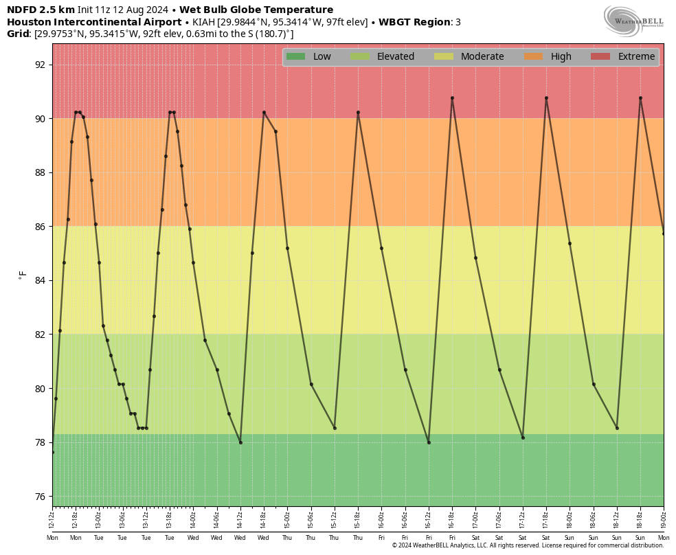
After some slightly drier air over the weekend—and you have to be a real connoisseur of humidity to have noticed it, but it was there—dewpoints will be back in the upper 70s today. This additional moisture in the atmosphere may help to squeeze out a few showers along the sea breeze this afternoon. But you’ll be lucky to be hit by a shower. I’d peg chances at about 20 percent south of Interstate 10, and 10 percent or less further inland. For the most part it’s simply going to be hot and mostly sunny, with temperatures generally in the upper 90s. Winds will be from the south to southeast at 5 to 10 mph, with slightly higher gusts during the afternoon and evening hours. Lows tonight will drop to around 80 degrees.
Tuesday through Friday
We can pretty much Ctrl-C, Ctrl-V Monday’s forecast for the rest of the week, which is to say each subsequent day is likely to be a copy of the former: Hot, mostly sunny, and with slight rain chances.
Saturday and Sunday
The only change for our weekend forecast is that, instead of temperatures in the upper 90s, we’ll see highs of around 100 degrees. Thanks, mid-August! I don’t see much impetus for a pattern change any time soon, sorry.

I felt that humidity change when I stepped out the door at 7am yesterday.
Took a brief pause to enjoy it.
What does the hurricane and tropical activity chart look like for the upper Texas coast? It always seems the peak here comes earlier than the overall, and really goes down when cold fronts start to arrive.
Historically speaking, activity in the upper Texas coast tends to peak in mid August through mid September. On very rare occasions we can get storms in October. In early October of 1949 a Cat 2 hurricane made landfall in Freeport which caused alot of damage and flooding rains in our area. But overall, hurricane activity drops for us once the cold fronts start pushing through because cold fronts push hurricanes away.
Saturday morning felt great outside! It was only 82 degrees and maybe 70% relative humidity! I’ll take it mid August.
A high pressure heat dome is severe weather just like a flood, freezing weather or a hurricane. Plants people and pets die during these events not to mention all of our electric bills go up. It’s reported around 30-40 people end up in the hospital each day due to the heat.
I had my defrost and windshield wipers on the whole time for my hour commute
Defrost in summer and an hour-long commute. That’s the most Houston statement ever!
Looks like the Canicula (dog days) is here to stay for awhile. 40 days of it.
Had my first run through the greenbelts of Kingwood since Beryl and am now convinced that Beryl far exceeded Ike in terms of damage. Some parts of the forest look like they’ve been logged. My memory was that Ike was cat 2/3 and the eye went right over KW whereas Beryl was touted as a strong cat 1 and passed further to the west. Not sure why the damage discrepancy is so apparent!
Could also be that the time between ike and beryl there has been extreme weather events that put stress on trees that eventually were taken down by beryl
Ike was a diminishing cat 2; Beryl was an intensifying cat 1 that did not diminish in strength immediately after landfall. The two were not so disparate and, as you mentioned, we were in the more damaging quadrant of Beryl. I live just across the river in Kings River.
So glad for this storm respite (^_^)
Not a fan of September as Ike came through then (which was personally awful for me). Also, it’s a teaser month. I am more than ready for late October now. 😀
thanks for your work!
Agree. September is a cruel month IMO because much of the country is starting to talk about Fall coming later in the month, while we have the potential to see some pretty nasty tropical activity. Labor Day has always been circled on my calendar and I certainly don’t plan any traveling around then or going somewhere for a long weekend.
Why does Tropical Depression 5 not have a cone on the Tropical Outlook on the NOAA site?
Hmmm. I’m at the NOAA site this moment, and I see the “Warnings/Cone Interactive Map” and the “Warnings/Cone Static Images” (among other choices) … tapped on the Static option and there’s the cone.
I see it. Thanks.
Can you please discuss the random pop-up storm that went over Sugar Land on Friday afternoon? Some people are calling it a microburst, but I have little to no idea what that is. Thanks!
The storms were caused by a cool front that helped trigger extra lift against the strong high pressure that is over us. A microburst is basically a blob of rain cooled air that rapidly collapses out of the storm clouds to the ground. Cool air is more dense than warm air so it falls to the ground due to gravity. This happens in virtually every storm. but In extreme cases this can cause destructive damage to trees and structures in the immediate areas that get hit by the falling cool air.
Microbursts usually affect a small area about 2.5 miles in diameter. But they have been known to produce winds as high as 168 mph. This is why the damage can be so severe and deadly in the small areas that receive them.
when I lived in Kenner, La, there was a plane crash about 2 miles from my house at the time that was caused by a microburst.
Yikes! Microbursts are very dangerous for aircraft for sure.
It looks like after Bermuda TD5 is likely to become a fish storm. That’s good for me. I fly to NY on Sunday and back on Monday.
Was definitely a touch cooler for our evening walks over the weekend. But no wind. Anyway, looking forward to the first real cool front in 5-6 weeks so we can walk when the sun is out.
So, by my count, we have 19 remaining named storms per prediction, and 16 weeks left in hurricane season. That’s a new storm every 6 days. Take into account November being typically quiet, that becomes a storm and a half a week. So just imagine a map of the Gulf with three or four storms churning in it at the same time (shudder).
Welcome to August 2023 but a teensy bit less worse folks!
I still remember the days back when August was really hot but not a heat index of 110 and wet-bulb temp of 90+ every day hot.
Watching the Atlantic is fine but the Gulf starts popping off too around this time
Although this article says “This has already been a very active Atlantic hurricane season” it also says there have been just four named storms so far. Have you any historical record of the number of named storms through this date in prior years? I tried to look that up but had no luck.
I didn’t check every season since 1850 but I did search through the top 10 most active Atlantic Hurricane seasons on record. So far what I found is that the most named storms to develop by this date was 10 during the 2020 season, which was the busiest on record. In 2005 we had 9 named storms by this date. In 1995 we had 7 named storms by this date. In 1887 and 1886 we had 5 Tropical Storms\Hurricanes by this date. Since I didn’t check every single season there could have been an anomaly somewhere that I missed. Most years the Atlantic Basin only sees 3 or 4 named storms by this date. We are at fairly typical levels this year so far. You can search through every Atlantic hurricane season on record since 1850 on Wikipedia. You can see every single documented storm between then and now. They lay it out pretty well. I’ve learned about multiple hurricanes that have struck our region in the distant past that I never would have known about by doing this.
Checked the NHC website about an hour ago … it shows the prior PTC5 as now a named Tropical Storm Ernesto … and thankfully, still destined on a north track.