In brief: As July begins we take a look back at June’s rain and temperatures, and look ahead to a hot week to start the month. Rain chances will be on the low side this week, but some isolated showers and thunderstorms will nonetheless be possible. Hurricane Beryl should remain in the southern Gulf of Mexico this weekend, so it’s unlikely to affect our area.
A brief June review
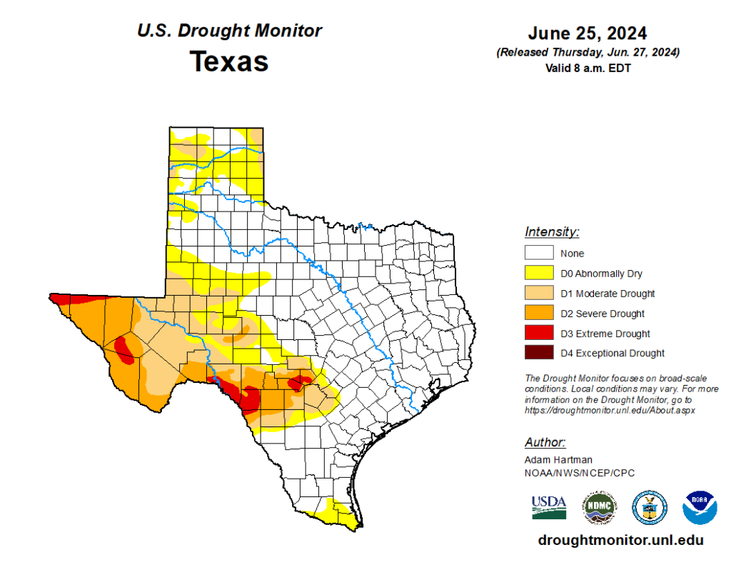
The month of June was wetter and warmer than normal. The city of Houston, officially, recorded 7.8 inches of rainfall, which is nearly 2 inches more than the average monthly rainfall for June. As a result of a wet spring, the entire eastern half of Texas, including all of the Houston metro area, is entirely out of drought conditions. It is a fine posture to be in headed into the hottest months of the year.
In terms of temperature, the city of Houston recorded an average of 84.6 degrees, which is 1.6 degrees above the normal temperature recorded over the last three decades. The average high, of 93.1 degrees, was not far off normal. However, our nighttime temperature averaged 76.1 degrees, which is well above the normal June temperature of 73.7 degrees. This is consistent with a warmer Gulf of Mexico and the background pattern of climate change.
Monday
If you’ve been enjoying our hot and sunny weather, you’re in luck. This pattern should persist for much of this week. In truth, there’s not a whole lot to forecast when high pressure is more or less in control of our weather pattern. High temperatures today will reach the upper 90s, with plenty of sunshine and humidity. Winds will be light, generally from the south, at 5 mph or so.
There is a bit of intrigue when it comes to the possibility of some rain showers late this afternoon as a weak boundary pushes into the area. This may generate some isolated showers and thunderstorms across parts of Houston, perhaps near downtown. Overall rain chances today are probably on the order of 10 to 20 percent for most locations. Lows tonight will be warm, perhaps dropping only to about 80 degrees.
Tuesday
A day similar to Monday, with the possible exception of highs being a degree or two cooler. The setup for isolated showers is similar.
Wednesday, Thursday, and Friday
The overall pattern remains the same, although with high pressure slightly relinquishing its grip we could see highs only in the mid-90s rather than the upper-90s. Ongoing rain chances are similar in terms of the afternoons and early evenings possibly seeing a few isolated showers and thunderstorms. If you’re wondering about July Fourth fireworks, everything looks fine at this point.
Saturday and Sunday
At this point it appears that high pressure may back off still a bit further this weekend. If so, that may increase daily rain chances a bit, to perhaps 30 percent. It may also bring daytime highs down into the low- to mid-90s range, so more in line with temperatures more typical for early July. We’ll see.
Tropics
We’re continuing to closely watch the evolution of Hurricane Beryl, but at this time there are no indications that it will move into the central Gulf of Mexico and threaten the upper Texas coast. The most likely scenario at this time is, rather, that it tracks across the Yucatan Peninsula and into the Bay of Campeche. After that time the odds that it moves north toward Texas are increasingly low. So, for the greater Houston area, nothing much to worry about at this time.
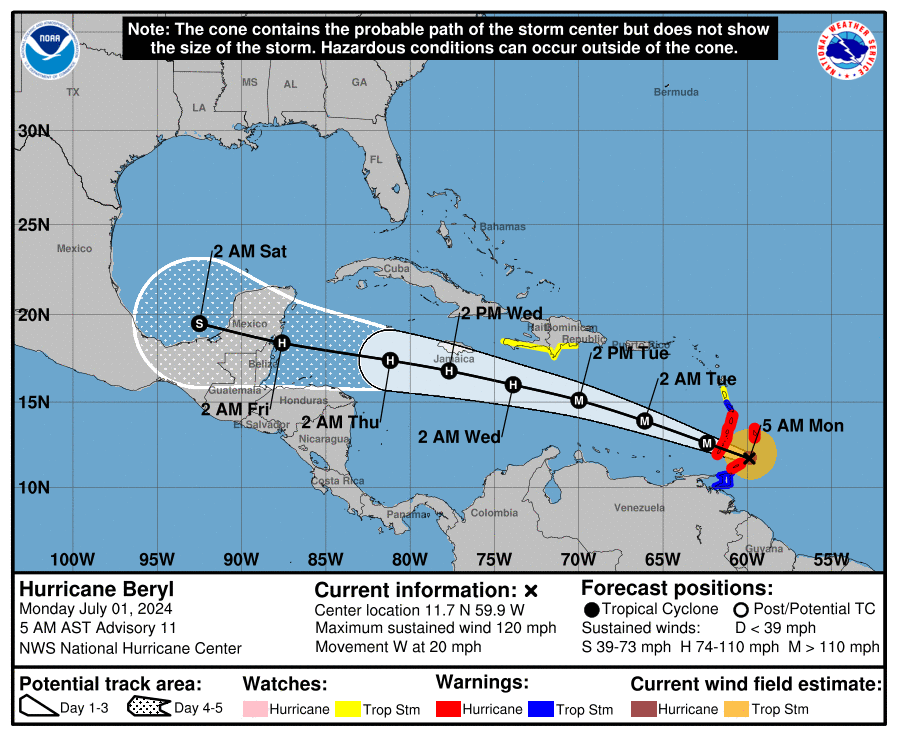
Also of note, Tropical Storm Chris formed last night in the Southern Gulf of Mexico, but it is already moving into Mexico near Tampico, and is not a concern for the United States. (Heavy rainfall, however, is likely in central Mexico). For full coverage of tropical activity, be sure and check out The Eyewall.

“we’re not really concerned about Hurricane Beryl and Texas” I hope SCW doesn’t regret saying this by next week.
I think we can all say the same for many layers of reasons…. but I’m still going to Costco to get a case or two of water and waterloo.
I bet your favorite phrase is “I told you so.”
I’m sure they hope the same; the bargain you make with a no-hype forecast is that they don’t exaggerate the likelihood of impact, and so risk underestimation.
I’d prefer they just tell me what’s most likely—I’m more than capable of scaring myself without their help.
Hopefully this high exits as soon as Beryl passes.
While it is great that east texas is not in a drought, If Lake Livingston dam does fail, Houston will lose 70% of our water supply.
At this point, the dam is not at risk to fail completely, it is only limited to just the spillway from the dam, which can be controlled/isolated by opening the gates manually. At this point, the Dam is not going to fail and flood everyone down river. They’ll open the gates manually to be able to dry up the adjacent spillway to allow them to repair it.
Geez, Mexico taking one for the team… yet again.
Pretty impressive, 5 day forecast is now a solid line, days 6 and 7 are dashed. How valid are the day 6 and 7 forecasts?
That is a huge jump in avg low temps for Houston. My back of the napkin avg lows for Corpus shows no change y/y. Why such a difference? I did not look at precipitation, but if I recall Corpus got rain in May of 2023.
Do you think this will impact flights over the weekend to Central America?
It’s not exactly true to say that June was wetter than normal. IAH happened to be in the bullseye of a pop up thunderstorm two days in a row, which pushed up totals well above surrounding areas. My house was slightly below average, which I think is consistent with the Houston area as a whole. Hobby airport was below average. Add to this the heat, and Houston needs the rain.
I prefer to remain in a state of paranoia until the thing is well on-shore.
While I don’t prefer it per se, that’s how I tend to roll as well. Sigh.
Would love it if you’d keep the dust outlook in the forecast when we are having a plume. My asthma would be so grateful to know when it can go away!!!
Thank you for never burying the lede! Y’all are the best.
What time should I walk my dog in Houston? I don’t want her feet to hurt from the heat!
The rain this last month was very much welcome but seems hit or miss for the most part. The official gage at IAH was at 7.8 but the gage about 5 miles away only saw about 2.8. This city is weird sometimes
Nature of the beast with these isolated pop-up t-storms. I’ve seen instances where one block will get soaked and the next one over is bone dry. It can really be a fine line.
Yeah, one of the ones in June was raining three houses down pretty hard and we got sprinkles at my house.
I don’t know the history of hurricanes hitting the Yucatan this early, but I have Honduran in-laws. In Honduras, they consider hurricane season to start in September, because normally the early storms go further north in early summer, then come our way in August & September, then Central America in October to early November.
Beryl is grazing across the top of Honduras & Nicaragua.
Beryl isn’t a threat to upper Texas coast? The Euro model seems to peg a direct hit on Houston in the most recent model runs.
Might have jumped the gun by declaring Texas safe from Beryl. The most likely scenario is that it goes into Mexico still but there has been an uptick in ensemble members from the GFS and Euro with more northern tracks into Texas.