In brief: Temperatures in our region will likely reach their highest levels of the year this week, with most locations pushing into the low-100s. However, this is probably the worst of it for the year, with somewhat cooler weather arriving by this weekend, and healthy rain chances next week.
Peak heating
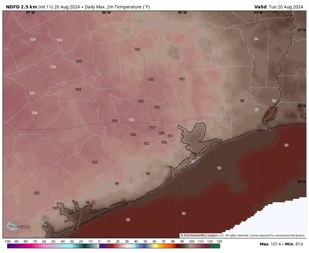
Our current stretch of weather will almost certainly be the hottest period of 2024. Houston recorded its hottest day of the year on Monday, 101 degrees, and it was the fourth day of triple digit temperatures in a row. Today could well even be a few degrees hotter, and Wednesday is likely to reach above 100 degrees as well. However, after this stretch we should slowly start to cool down and reach the mid-90s by the weekend. Better rain chances and possibly even cooler temperatures are on the horizon for next week, which gets us into September.
Tuesday
Today will be extremely hot. Most of the Houston region will see daily high temperatures in the low 100s, with mostly sunny skies and only light winds from the west. This probably will be the hottest day Houston experiences this year as we feel the influence of high pressure and sinking air. Low temperatures on Tuesday night will only drop into the low 80s.
Wednesday
This will be another very hot day, with sunny skies. Temperatures, however, may be 1 to 2 degrees cooler than Tuesday.
Thursday and Friday
As high pressure backs off, our temperatures will ease slightly. Most of the region is still likely to see highs in the upper 90s to 100 degrees, however. Skies remain mostly sunny with rain chances near nil.
Saturday and Sunday
As high pressure backs off further, we should start to see some partly cloudy skies this weekend, and that will assist the downward trend in temperatures. It’s still going to be hot, mind you, but highs will peak in the mid-90s for most locations, with nights dropping into the upper 70s, probably. Rain chances will also return this weekend although they’ll start out on the low side, perhaps on the order of 20 to 30 percent daily.
Next week
In the absence of high pressure, our region will lie exposed to the influence of Gulf moisture. This is likely to produce at least partly cloudy skies next week, and daily rain chances. I think highs will be in the low- to mid-90s, and much of the area is likely to pick up between 0.5 and 2 inches of rain—although I am getting deep into the realms of speculation with that prediction. The bottom line is that our overall pattern should change from what has otherwise been a very hot, sunny, and rain-free August.

It will be a nice change to have actual clouds and possible rain next week. Both should take a few degrees off of the high.
And, we’re on the downhill side of August, which I won’t be sad to see go.
No High Pressure isn’t a good thing…remember, we’re still in the midst of Hurricane season. Being exposed to Gulf moisture of any kind should make any vigilant Houstonian nervous. Powerful storms can appear suddenly in any form.
Exactly.
For people anxious about hurricanes, I just want to point out that at no point this month has high pressure deterred a hurricane from our area. We haven’t had a hurricane in August this month because there has been little to no development out there, which has nothing to do with high pressure here. Remain vigilant, of course, but high pressure backing off does not automatically equal a hurricane here in Houston. Personally I’m happy to see the high pressure go, it gives me headaches (literally).
Yes, but high pressure would keep one that does develop from coming here. Remember, we are in the height of hurricane season right now. This from someone who is still displaced from Beryl while they work to fix my house from that damage. And it was “only” a category 1. Needless to say, as much as I hate the heat, I would rather have the high pressure for as long as possible thourgh hurricane season.
Note – I’ve lived here for almost 60 years and this is my first time having super PTSD from hurricanes.
High pressure/sinking air systems have definitely impacted both tropical system development close to us (Campeche 1.5 weeks ago) & tropical systems from being steered here (like Debby). There will be tropical impacts once it departs.
Thank you
storms are needed, humans are not
Feel free to go run out into any storm or tornado. Meanwhile, humans will continue to navigate their lives.
Lets put things in perspective. We survived 3months of this last year with 45days in the 100s with high 100s at that!
As someone who moved to Houston from CA earlier this year – hearing about last year’s summer scares me.
This summer has been brutal, especially as of late. It’s hard to imagine that many days of triple digit heat + humidity
To be clear, last summer we had several days of a raw temperature of 113 degrees, the heat index was well into the 120s.
Welcome to Houston; Welcome to the fire.
As bad as this summer has been, it has been a cakewalk compared to last summer. The summer of 2023 and 2011 were some of the most miserable experiences one could have down here. I have never experienced a northern winter but as someone who loves cold weather, I’m sure I would prefer winter in Minnesota than Summer in SE Texas. That could change if I ever go through a Minnesota winter though.
Same. If it weren’t for my family here, I would move to the Pacific Northwest.
Me too! Family, a two sided coin.
My Father was a Pipeline Spreadman so I have been in 44 of the contiguous states- some were very pretty. Dad’s last job worked out of Houston, so I started my “worklife” here. We got here about 3 days before “Carla in ’60.” That was bad.
2 years later, I met a girl that became my Wife. We have lived and made a family here…and have lived through all the weather shots taken at us since then. Despite being inconvenienced by Houston weather, I owe Houston for 120# pounds of good looking woman and 2 Sons she gave me. That’s good.
I should also nod my head to Pasadena as well. I had a well-paying job in the Chemical Industry with a good Retirement plan. It’s All good.
I’m glad you are satisfied, not everyone can say that and mean it.
BTW: “I owe Houston for 120# pounds of good looking woman and 2 Sons she gave me.”
Um, you might want to rephrase that.
Houston weather is borderline uninhabitable and it’s only going to get worse. I moved out of Houston last year and while I now contend with some cold and snowy days, I will never go back to Texas. It wasn’t as bad 25 years ago when I moved there. my advice to anybody even considering moving north… Do it. You won’t be sorry.
I’ll be headed to the mid-South not long after retirement. Not just the climate but the crime, poverty, sprawl, and corrupt local governments are making Houston an impossible place to live.
All true, but you forgot to mention the crappy infrastructure- crumbling water mains, potholes, lack of lane striping, etc.
You’ll probably get your chance as we transition back to La Nina this winter/next spring. These types of summers will, likely, be more the norm than what this summer has been.
I enjoy receiving these forecasts, but the charts are very difficult to read and interpret due to very small fonts.
@Jeff Johnston … zoom in. I can do it on our two Samsung smartphones, on our Dell Latitude laptop, and our desktop machine, all using the Brave browser. But any browser can zoom in.
If this it’s as bad as it gets, then this summer can be classified as a win. Decent rains in June & July , Beryl (cough). So a 3 week span of hot dry weather is nursery school stuff compared to what we had last summer.
No high pressure? Not a good thing. It means we might get a hurricane?
Shouldn’t those clowns over at centerpoint be trying to make our lives worse with rolling blackouts again? It’s almost like they’re not even TRYING to kill more of us.
I am so confused. are we expected to have rolling blackouts on the distribution side? I see we’re getting close for total power availability at roughly 6pm when the solar panels lose effectiveness as the sun sets, but that’s a state wide generation problem.
Although, I have seen CenterPoint using the impetus to actually do stuff in my neighborhood (diverse community of starter homes). All the trees near the lines are getting absolutely topped, the canopy cut wherever it’s expected to grow into the utility or electricity lines. Doesn’t look great but that’s what’s gotta happen and what happens when people plant tall trees under power lines.
Today’s ERCOT dashboard shows an almost-merge between forecast demand and anticipated capacity this evening. So if things like that are going to happen, then today may be the day.
Centerpoint is gaslighting us.
They’re on ‘good behavior’ mode.
I wish you all could change something on the post so that the charts can be enlarged easily. I get the general idea about, for example, the Wet Bulb chart, but on my laptop I can’t read any of the details, same is true on many other charts and graphs you include.
@John Pennell … zoom in. I can do it on our two Samsung smartphones, on our Dell Latitude laptop, and our desktop machine, all using the Brave browser. But any browser can zoom in.
I never truly relax in late August because we are never out of the woods for extreme heat in September. We have been stricken with triple digits many times in September including last year. Even in late September we can still get 100 degree temps. In late September of 2005 most of our region hit 100 degrees several times. That was a freak one off occurrence but freak heat waves are become more common as of late. Our summers are also getting longer and longer as well.
October is the month where we can usually finally say goodbye to the extreme heat but it is still a little warm for my taste. November is the month I look forward to the most because most days are pretty mild with highs in the 60s and 70s most of the time with a few 80s thrown in here and there.
I’ve been watching several YouTube weather creators talking about an early and chilly fall the eastern US and all the way down to the Gulf Coast. I know these guys are looking for clicks it they have been consistent in their predictions. Is there any chance they may be right?
Friends of mine were in Ontario along the northern shore of Lake Huron a few days ago and observed fall color already appearing in the forests.
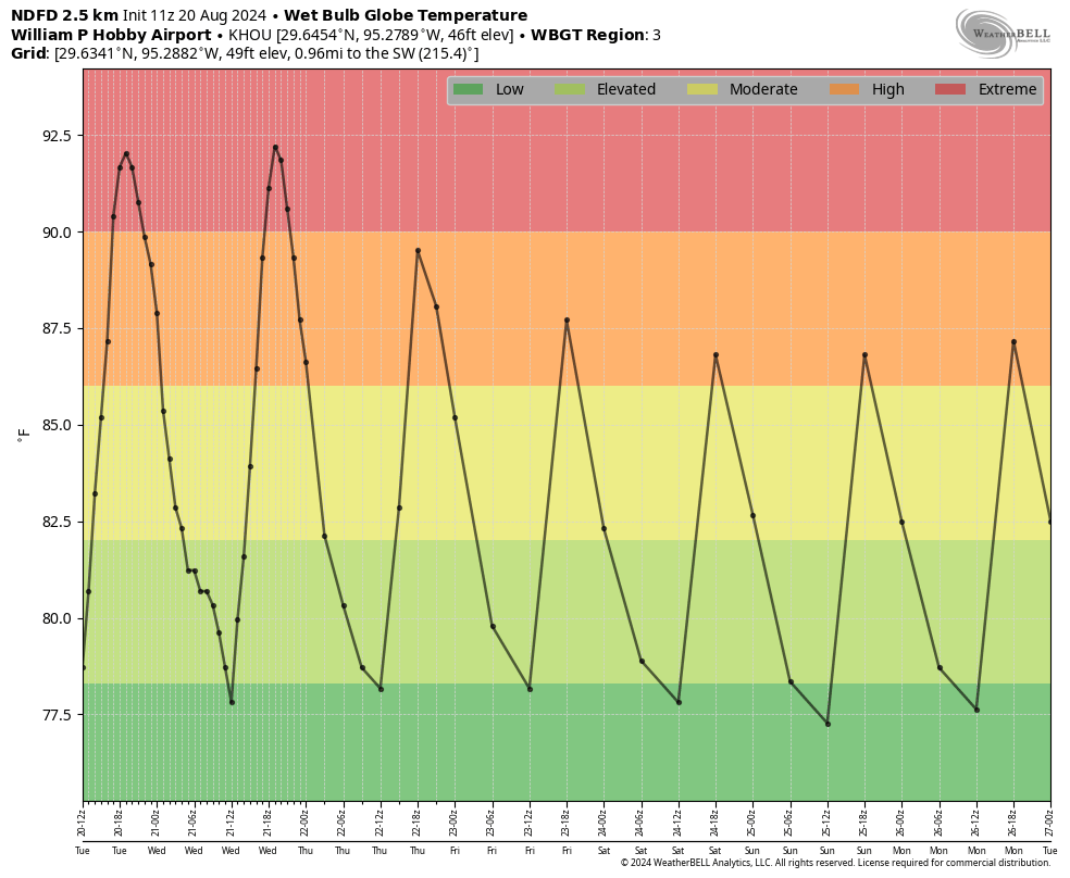
Maybe it’s memories of last summer combined with what it felt like to be without power for four days after Beryl, but the rest of July and August have felt downright pleasant by comparison. Hurricane-wise the slight retreat of high pressure is only one part of the picture. Also depends on the eastern high’s position so maybe not all bad news. But the peak of hurricane season is still 2-3 weeks out so guard has to stay up as our shields drop down a bit.
This is fascinating weather. There is an anticlone over Matagorda. A strong ridge over New Mexico. The barometer is falling and there’s not a cloud in the sky. Clear blue, no haze. Relative humidity (near downtown) is only 33% at 102F. Wow.