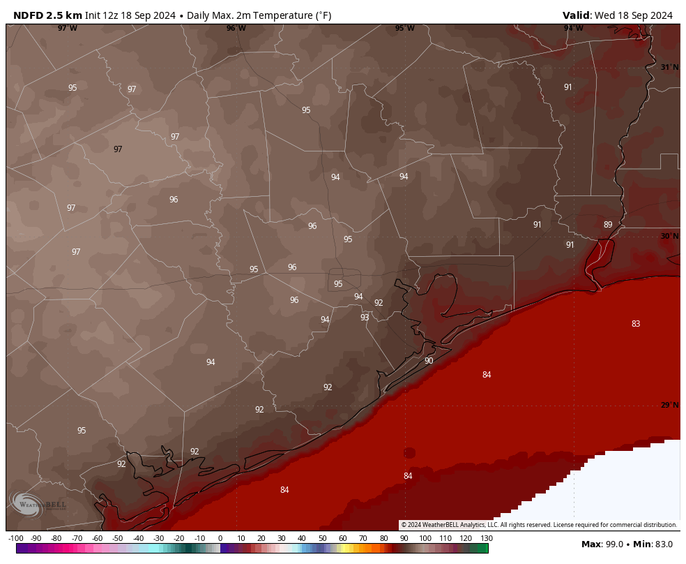
In brief: Houston’s heat continues, with daily highs in the mid-90s for the rest of the week. We’ll cool down ever so slightly this weekend, and low-end rain chances return next week. We’re also keeping a wary eye on the tropics, as the Caribbean Sea stirs.
A note on the Moon
Last evening, if you were outside looking up, you may have noticed a full Moon. It looked pretty spectacular. However you may have seen a bit of blurring or dimming at the top of the Moon. This was, in fact, a partial lunar eclipse. Only about 8 percent of the Moon’s surface was covered before Earth’s shadow started to recede. I apologize, if I had realized this was occurring in advance, I would have noted it in yesterday’s post.
Wednesday, Thursday, and Friday
Yes, I’m lumping all three days together because they’re all going to be very similar. Each day will have high temperatures in the vicinity of the mid-90s for most of Houston, with slightly cooler daytime temperatures on the coast. Skies will be partly to mostly sunny, with generally light winds from the southeast at 5 to 10 mph. Lows will only fall into the upper-70s. Rain chances are effectively zero, although we cannot rule out a very isolated shower here or there.
This is probably the warmest weather we’re going to see for the rest of this year, so if you like the heat, enjoy. And if you prefer somewhat more temperate temperatures, well, hold on for a little while longer.
Saturday and Sunday
More of the same, however as high pressure weakens a bit we could see daily temperatures slide down by a couple of degrees. Overnight lows, too, could drop into the mid-70s. Skies will be mostly sunny, with low- to non-existent rain chances.
Next week
Temperatures look to remain in the low 90s next week, with partly to mostly sunny skies. Rain chances continue to look fairly low, but may rise to the 20 or 30 percent range by Tuesday or so, with similar daily odds for the remainder of the week. As we get closer to next weekend it looks like we could see some kind of front, perhaps backdooring in from the northeast, but there’s not certainty in the models yet. So we can have some hope for a cool front with some drier air about 10 days from now. But for now, all it remains is a solid hope.
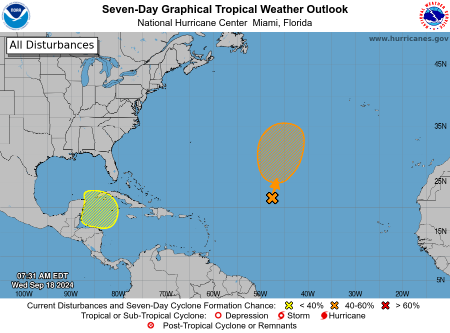
Tropics
The National Hurricane Center has started to highlight an area in the Caribbean Sea that we’ve been talking about for a couple of days. It still appears as though development will be slow, with nothing forming for at least the five to seven days. If a tropical low does develop—and there is no certainty at all that it will—all of our best models are pretty well divided on what will happen in terms of where it goes. For us along the upper Texas coast this is probably not something to be too concerned about. However, given the high uncertainty we’ll just have to see what happens.

Just look at the bright side, at least the peak of summer is over. We are not facing a week straight of 100* degree temperatures with heat index values of 112+ anymore. Even though it isn’t cool and crisp yet we have still made noticeable progress since August. 👍
Yeah – I don’t know if I’m damaged from last year, but these recent temps in the low to mid 90s don’t bother me at all.
Would I like a cool front? Absolutely. But there is a HUGE difference between the heat from last year and this year.
On the tropics, what does “probably not something to be too concerned about” mean? I think you’re saying “at this early time, every point from the tip of Florida to the central Mexican coast has the same chance of getting a tropical storm from this”
Is this what you mean?
Jeez. Just interpret the forecast to mean in this general Houston vicinity – this is Space City Weather.
What? You have never noticed the mental gymnastics Matt J goes through to bring any storm into the Houston area to cause catastrophic damage, even when the storm is forecast to simply spin around in the Atlantic?
chuckling
Or Matt is a liw key troll..
*low
whoopsie
😉
I so appreciate your weather reports. I can trust your no hype style and respond to your warnings in confidence. Great work guys!
I’ll be celebrating a high of 92/ low of 74 when we get to it. Crazy.
Hypothetical wild crazy guess: Tue the circular possibility creeps above Mérida, on Wed it’s in west-central Gulf, Thur it’s heading to northwest FL coast.
But no doubt, nothing’ll happen 🙂
Correction on the wild guess – it’ll linger in the Gulf a couple more days and arrive along coastline below Lafayette on Sat, 28
But it’s doubtful
Then why make a wild prediction if you already have doubt, then make another wild prediction and have doubt again? one more wild prediction except no doubt this time stranger
Taking my daughter camping the weekend of 9/28. Switching from constantly checking the Tropics to constantly checking that Front that’s been coming in “about 10 days from now” for the past 3 days 🙂
Camping where?
Maybe Colorado! 😀
I believe previously you had noted September 20somethingth as the day past which storms typically don’t hit the Houston area because the steering currents/fronts push eastward. Based on your comment of 5 to 7 days to form, would that not be a reasonable reason to expect the storm, if it forms, to drift eastward away from us?
Lunar eclipse? I thought a giant dragon was eating the moon.
Second the desire for rain and it seems the pressure ridge drifts off by Tuesday. The cold front in the cast makes no mention of wet or dry but GFS appears to be wet. I think I need to move way east of here. HOU has been in rain deficit since Harvey and the stretches of hot-humid-dry are becoming mind numbing. Thermophile with wet on the side!
Third the desire for rain!!