In brief: Temperatures are going to get rather cold this week in Houston, with a light freeze possible in the urban core of the city on Thursday morning, and temperatures in the upper 20s possible for inland suburban areas. After that we’ll see a warming trend into the weekend, and next week.
Mardi Gras
The largest celebration of Mardi Gras in Texas begins Friday in Galveston, and runs over the next two weekends. This year I’m excited to say that Matt and I will be the grand marshals for a parade on the second weekend, the Ben E Keith Parade on Saturday March 1, at 4 pm CT. More information on the route can be found here. We’re excited to see everyone.

Our parade is two weeks from now, but we can begin to get a sense of the weather for opening weekend of Mardi Gras. Friday looks to be chilly, with temperatures in the upper 40s, and gray skies. There will be a slight chance of rain on Friday afternoon and evening. Saturday will be warmer, in the 50s, on Galveston Island, but with a decent chance of rain during the daytime. Sunday looks pretty nice, likely with mostly sunny skies and highs in the low 60s. The forecast for the following weekend, of Saturday March 1, is hazier. But temperatures do look to be fairly warm.
Spring is around the corner?
There is no question that this week is going to be cold in Houston, with much of the area likely to see a freeze on Thursday morning. The chill will linger into the weekend. But after that? Next week looks considerably warmer and then we’re on into March. We cannot definitively say that this week will bring our last freezing temperatures of the 2024-2025 winter season, but I think it’s a distinct possibility. So if you like winter, enjoy this week. And if you’re tired of the colder weather, change is on the way.
Monday
Temperatures are in the upper 30s to lower 40s across Houston this morning, and we’re headed toward a fine day. Expect highs in the lower 60s with plenty of sunshine today. Light winds will shift from the northeast to southeast as we return to an onshore, warmer flow. As a result we will see increasing clouds this evening, and low temperatures tonight only falling into the lower 50s.
Tuesday
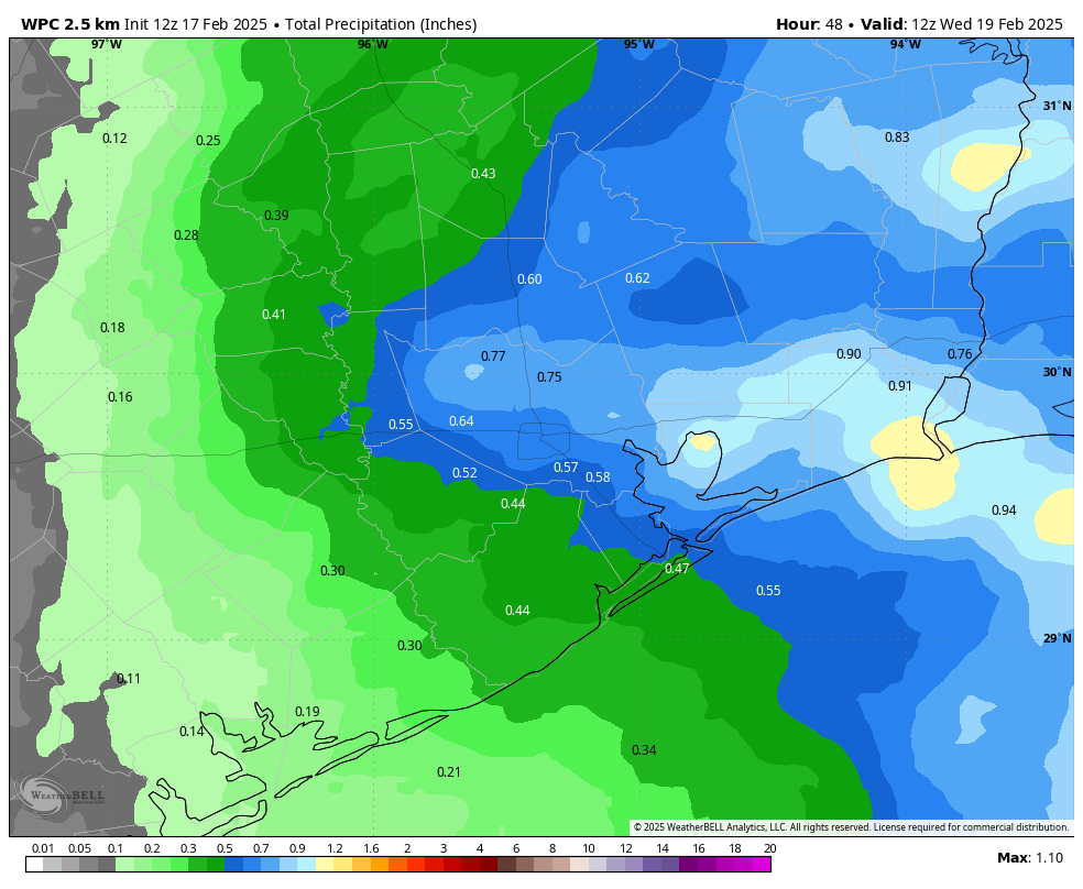
This will be a cloudy, warmer day with highs of around 70 degrees. We’ll see a chance of light to moderate showers for much of the day, but I don’t anticipate anything too disruptive. A cold front will approach the area during the evening hours, and we could see a broken line of showers and thunderstorms move through the area between 6 pm and midnight. Overall accumulations for most of the region through Tuesday night should be on the order of 0.5 inch. Drier and much colder air will filter into the area after midnight, leading to cold conditions on Wednesday morning of around 40 degrees.
Wednesday
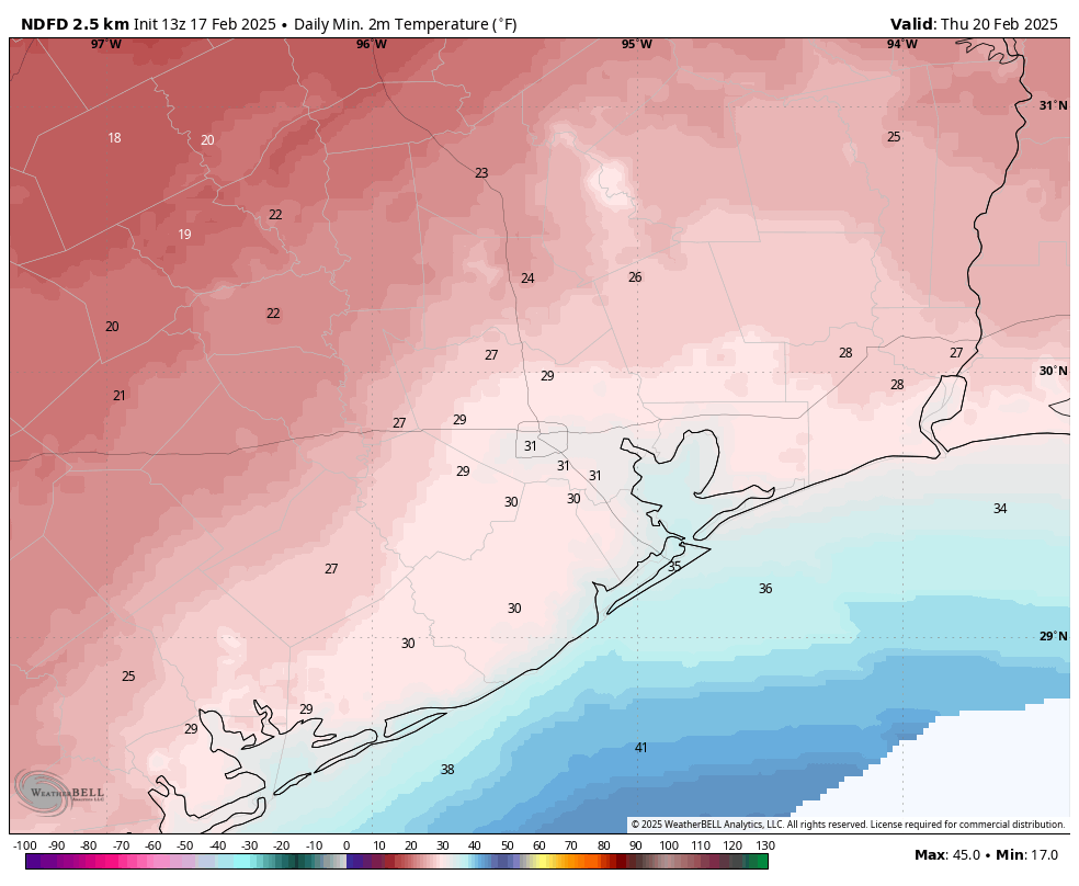
This will be a cold winter day, with partly sunny skies and gusty northerly winds. Highs may reach the upper 40s before temperatures plunge on Wednesday night. At this time I expect lows of about 30 degrees in the city of Houston—hence our post on Sunday about expecting a light freeze rather than a hard freeze—as skies clear out some overnight. Some well-inland areas will likely see temperatures in the mid- to upper-20s.
Thursday
This should be a mostly sunny, chilly day, with high temperatures in the mid-40s. Expect another cold night, although temperatures should be a couple of degrees warmer on Thursday night than Wednesday night.
Friday
Clouds return Friday, and this should help to hold highs in the low- to mid-40s for much of Houston. As atmospheric moisture levels start to recover some, we could see some rain chances later on Friday or Friday night, although accumulations look slight.
Saturday, Sunday, and beyond
We’ll begin a warming trend this weekend that will continue int next week. There will be a chance of light to moderate showers on Saturday, with high temperatures near 50 degrees in Houston. Lows on Saturday night will fall to around 40 degrees with clearing skies. As noted in the Mardi Gras outlook above, Sunday looks sunny and fine, with highs in the vicinity of 60 degrees.
Highs for most of next week should slot into the 70s, with mild nights in the 50s and 60s. It really should feel spring-like for the rest of the month of February.

WOW! You and Matt “Parade Grand Marshals” during Galveston Mardi Gras!! Congrats!!
I normally don’t talk down the TV morning weather folk but I have to this time. All of them 2, 11 and 13 used the wind chill temperature as their forecast lows. Yes, they did show that the temps were wind chill but if you weren’t paying close attention, or if the volume was off, you would think we are going to be in the low 20’s Thursday morning. One of them even called this “the definition of a hard freeze”. Come on guys, don’t use the actual temps for your highs then use the wind chill temps for your lows. Doesn’t seem very professional.
That happens frequently with 13…despise it!
To be fair, if your not paying attention to a weather forecast as you describe in your post, then much of the blame should also go to the viewer.
I agree that’s why I stopped watching them, always hyping up and lying.
Predicting the final freeze on February 17th is pretty bold.
Thanks for all you do!
When you speak of inland areas does that mean the SW part of town is likely to see a freeze? Light freeze of around 30?
Thanks again.
Yeah I’m sure we will be in the upper 80s if not 90 degrees later next week because there is no proper medium between winter and summer temperatures anymore.
For all the whining comments we often see on this site about how bad our weather is, I was shocked to read on the BBC site this morning that ten people had died from storms wracking other parts of the South East including 9 people killed in Kentucky – including a mother and child, all on top of Helene. We are lucky considering how bad it often is elsewhere.
The low in Rugby, ND is -44 tonight and hundreds of cold records are being set in the upper Midwest.
Makes Houston look pretty good…
you know the temp is low when it doesn’t even matter if it’s C or F.
I noticed today that my lantana, hamelia and beauty berry are already shooting, much earlier that before, so the climate around here is clearly changing into a sub-tropical band. We might as well get used to it.
Most of my sub tropical cold sensitive plants and shrubs died in the near blizzard and freeze. This was 3 out of the last 4 years they succumbed to the polar vortex. We may have to get used to these massive temperature swings…
Unless we enter another mild period like in the 2000s when we had very few hard freezes.
Oh man. High of 60, low of 40 is probably my favorite weather for this area. Only a couple more shots at it left this year. Enjoy the day!
Up Magnolia way, we expect low 20’s on Thu morning (based on past experience over the years).
We just got an email from ERCOT – partially quoted below:
ERCOT has issued a Weather Watch for February 19-21 due to extreme cold weather across the ERCOT region, higher electrical demand, and the potential for lower reserves. Grid conditions are expected to be normal. For more information, visit our TXANS webpage.
What is an ERCOT Weather Watch?
An ERCOT Weather Watch is an advance notification of forecasted significant weather with higher electrical demand and the potential for lower reserves.
At this time, grid conditions are expected to be normal, and there is not a current expectation of an energy emergency. Texans should continue to monitor real-time and extended grid conditions at ercot.com.
What do I need to do?
No action is needed. You can monitor current and extended grid conditions on ercot.com.
—end quote
It’s funny you mention Ben E Keith. I worked in the Anheuser Busch wholesale industry (Standard Sales) and Ben E Keith had the largest Budweiser warehouse in the country in Dallas. Today…I believe Silver Eagle has that title with the largest warehouse in Houston.