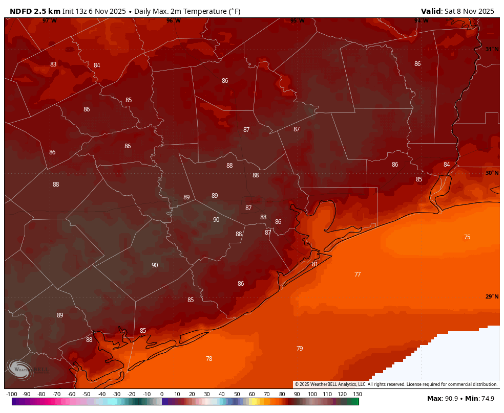
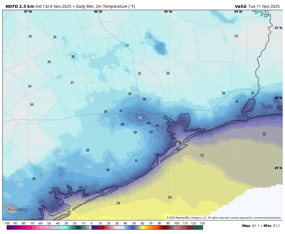
In brief: In today’s post we explore the very warm highs of the region’s forecast, including the potential for an unprecedented 90-degree day in November. After heat on Friday and Saturday the region will experience a sharp cool down as a front arrives to push lows down to around 40 degrees.
90 in November?
In its long history Houston has never recorded a temperature of 90 degrees, or higher, in November. This is because days are shorter, the Sun angle is lower, and generally we are seeing regular fronts that bring cooler air into the region. However due to a combination of uncharacteristic warmth and compressional heating, it is possible that we could hit 90 degrees on Friday or Saturday at the city’s official monitoring station at Bush Intercontinental Airport. It will be close, and we’ll be monitoring things.
Houston may hit 40 degrees on schedule this year
Conversely, our region is forecast to have its coldest nights of the season, so far, next Monday and Tuesday mornings. There is a decent chance, probably at least 50 percent I would guess, that the city’s official weather station at Bush Intercontinental Airport will hit 40 degrees. Naturally, being a weather nerd, I wondered whether that was early. So I checked the data. Answer? It would be, if only slightly. Based on data going back to 1889, the average date of the city’s first 40-degree (or cooler) temperature reading is November 13th. (Next Monday is the 10th, and Tuesday is the 11th).
Thursday
We are seeing fog develop across the region this morning, and the National Weather Service has issued a dense fog advisory through 9 am. Please take care driving. This is due in part to very light winds and temperatures and dewpoints being an identical 60 degrees in many locations. When the fog clears we will have a sunny day with high temperatures in the mid-80s. Lows tonight will drop into the low- to mid-60s, and dense fog may very well return early on Friday.
Friday and Saturday
These will be sunny and hot days. The National Weather Service presently forecasts a high of 88 degrees at Bush Intercontinental Airport on Friday, and 89 degrees on Saturday. We’ll see if we hit that historic 90-degree mark. Friday night will be warm, with temperatures in the mid-60s. I expect the front to arrive sometime between Saturday evening and Sunday morning, bringing drier and cooler air into the region. At this point I don’t anticipate much, if any precipitation with the front.
Sunday
A breezy and cooler day with clear skies. Expect highs around 70 degrees. Winds will be gusty, especially during the middle of the day with maximum gusts of 25 to 30 mph possible. Lows on Sunday night will drop into the low 40s on Sunday night, with cooler conditions for outlying areas.
Monday
A chilly day, with highs perhaps topping out in the lower 60s. Winds will die down. Lows on Monday night will drop to around 40 in the region, with inland areas seeing the 30s.
The rest of next week
After the cold start to Veteran’s Day, we will see a gradual warmup, with highs likely returning to around 80 degrees by Wednesday, and remaining on the warm side into the weekend. Rain chances look low. Another front is possible later next weekend, but our overall confidence in the forecast is low.
