In brief: August will continue to August in Houston, with hot weather, hazy skies, high humidity, and at least some low-end shower chances. We will continue to see the heat persist into next week, but that will also hopefully shield us from any tropical troubles.
Today
More of the same continues today, but this time we may add a slightly better chance of a few showers or thunderstorms this afternoon. The setup is a bit complicated, but we have a couple boundaries headed our way, and this coupled with daytime heating and the inland moving sea breeze off the Gulf could help at least fire up a few thunderstorms around the area. Otherwise, it’ll be another scorcher with highs near 100, heat advisories, and air quality alerts for high ozone.
Weekend
More of the same. There will continue to at least be subtle rain chances this weekend, but consider yourself lucky if you get a downpour. Highs will be in the upper-90s, with more borderline heat advisory criteria. I guess that’s a little cooler? I don’t know. Cooler or not, it’s still going to be hot.
Next week
We’ll keep this simple today: There may be some subtle nuance day to day in terms of exact temperature or exact shower chances, but the majority of next week looks stable and hot. High pressure is in control (more below), and that means sun, highs near 100, and heat index values pushing heat advisory criteria daily.
While we cannot entirely rule rain out of the forecast next week, daily chances really look meager right now. This is as reminiscent of last summer as we’ve seen so far this year.
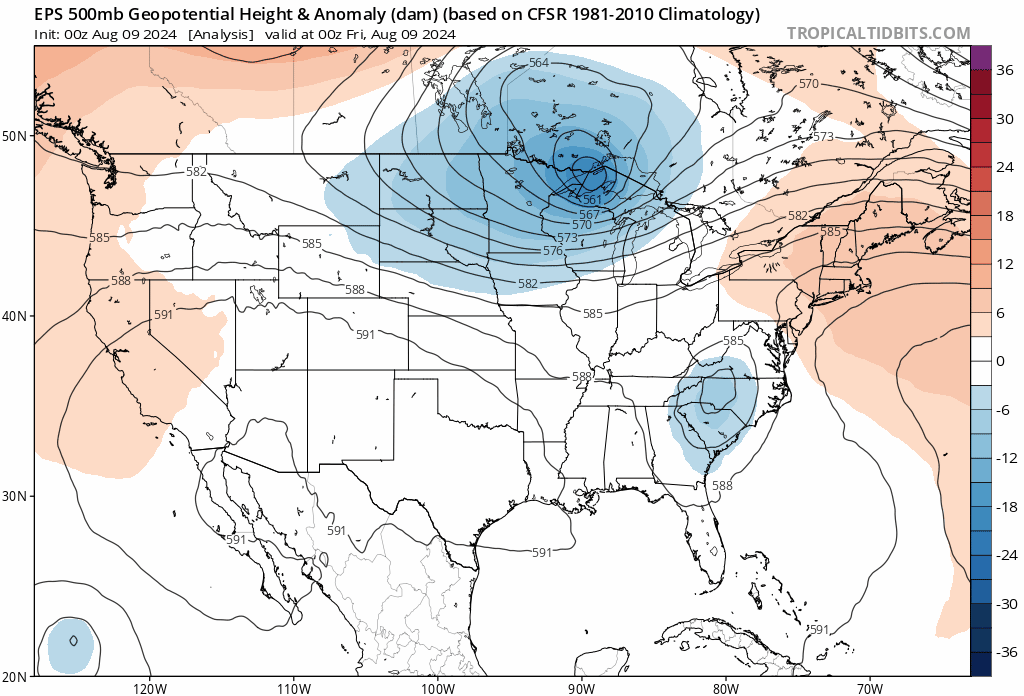
The reason for all this is that high pressure in the upper atmosphere, something that’s been relatively absent this summer over Texas is finally locking into place. We usually see this at times during summer leading to more concentrated “heat wave” type periods. Well, it’s coinciding with August and our worst heat this year it seems. As long as this stays in place, which it looks to do for the most part over the next 10-12 days at least, we will continue with a pretty stable forecast. If you look at the map below, just notice the “594” circle over Texas. That’s a pretty strong sign of good heat and mainly dry weather in Texas in August.
The upshot of all this is that it would likely keep us protected from any tropical nonsense, so long as it stays in place. We’ll see if that’s the case. Check The Eyewall later this morning for the latest on the next Atlantic wave, which we currently believe will stay east of the Gulf.

Great news!
Extremely hot and humid until further notice.
Good time for the weather guys to take a vacation somewhere up north. Just be back by Labor Day in case something is about to change.
Since we got so much rain in July, I’ll take this high pressure for the time being if it means keeping more tropical systems at bay.
“Houston now looks to remain under the grip of high pressure….” Good. Hurricanes suck. I don’t care about the heat, I’ve got air conditioning for a reason.
Until it breaks down at the wrong time or ercot starts warning of power conservation
Again, I’ll take having to take a few extra swigs of bottled water or having to find a cooling center or even renting a hotel room as opposed to some Cat 5 monster Rita-styled Hurricane that flattens my neighborhood, especially since our infrastructure (and I’m not talking about CenterPoint, even fences got broken down) can’t handle a ‘simple’ Cat 1 Beryl if it makes a direct hit.
If August turns out to be a shutout as far as rain,it still would go down as a pretty decent summer given June and July being rainy especially July.
No complaints, actually a nearly best case scenario. Beryl and Debbie churned up the Gulf a bit, too, and took the edge off of the surface temperatures.
Good. After Beryl, this is exactly what I want for August. And for the first half of Sept, too for that matter. Matter of fact, I’m happy to let this high pressure stay in place until our first front of the Fall pushes it out. We got plenty of rain through the Spring and early Summer. The reservoirs are full so just run your sprinklers in your yards.
I’m depressed about not having our typical afternoon summer showers (at least the kind of normal weather we had 10 years ago) but happy we’ll be shielded from any tropical systems. Between the freeze in 2021, the derecho and Beryl, I can’t deal with many more disasters. It gives CenterPoint some time to strengthen things up too.
Officially only two 100 degree days at IAH this year. I think our average is around 6-8 days topping the century mark. I think I will take the under “8” days for the year…
After last year and the chatter about the “new norm” I wonder how many “over” takers I could have got?
The air temperature at Angleton airport is 96 with a dewpoint if 81 degrees. That puts the current heat index at 118. That is sad considering the wind is blowing out of the north right now. The air should be slightly drier. I am a little confused as to why the dew point is so high. Yes, August is always hot but it didn’t used to be an automatic death sentence of heat and humidity to this level every single year like it is now.