In brief: In this morning’s post we dig into our region’s very warm start to winter, which will continue this week. We probably will set more record highs. The post then explains why this is probably not the end of winter.
Who killed Jack Frost?
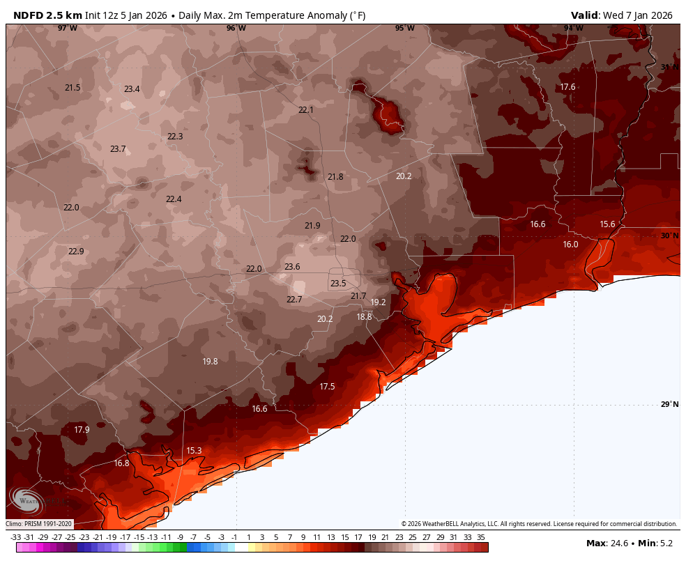
The month of December ended up 4.0 degrees above normal, and so far January is running much higher than what we typically experience at this time of year. We’ve already set one record high temperature this year (84 degrees, on Friday). This week will be no different, with record highs on Tuesday (80 degrees), Wednesday (81 degrees) and Thursday (79 degrees) all in play. Perhaps Friday as well, we will see.
By that point we will be nearly one half of the way into climatological winter, which spans from December through February. So is it just going to be super-warm weather all the way? I don’t think so. At the risk of being wrong (a hazard of the job!) I think that after a strong-ish front arrives late Friday or early Saturday of this week, we will fall into a cooler pattern for awhile. By this I mean days in the 60s and nights in the 40s. There are some hints of perhaps even colder weather toward the end of January, but who knows, really.
The bottom line is that we still have nearly eight weeks until March 1, and a lot can happen weather wise. So yes, this week is going to be unseasonably warm, just like a lot of December. But after that? We shall see.
Monday
Temperatures this morning have fallen to about 50 degrees across the metro area, which is the coldest we are going to get until at least next Saturday, but still warmer than is typical for January. Mostly cloudy skies this morning will give way to plenty of sunshine this afternoon, and this will allow high temperatures to push into the upper 70s for most locations. Winds will shift to come from the south over the course of the day. Lows tonight will drop into the low- to mid-60s.
Tuesday and Wednesday
These look to be the warmest days of the week, with mostly sunny skies and highs in the low- to mid-80s. One sobering note is that our all-time record high temperature for both the month of December and January is 85 degrees. That is potentially in play on Wednesday. With higher dewpoints (and humidity) we may also see some patchy fog on most mornings this week, including these days. Lows will again be in the 60s.
Thursday and Friday
A disturbance will precede the passage of a cold front late this week, and this will lead to the potential for some light showers on Thursday and Friday. I know we need rain, but unfortunately this frontal passage is unlikely to deliver on that score. Both of these days will have about a 20 or 30 percent chance of rain, but accumulations look slight. Daily highs will probably be in the vicinity of 80 degrees, with increased cloud cover. There will be plenty of humidity. That should change some time on Friday night as a robust front sweeps through.
Saturday and Sunday
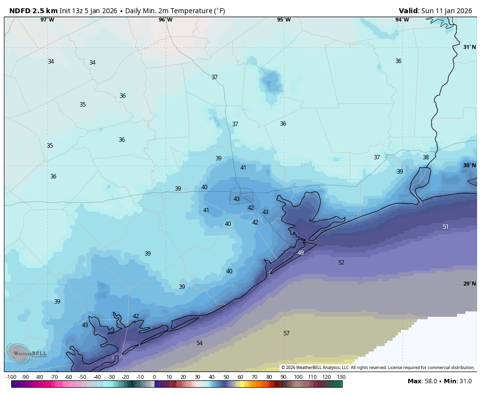
The weekend looks decidedly cooler. I think highs on both days will reach the lower 60s, but this will depend on the amount of sunshine after the front. I think Saturday will see a fair amount, but Sunday could be partly cloudy, at least. I did a deeper dive yesterday into conditions for the Houston Marathon on Sunday, January 11, and that forecast more or less holds. If anything we’ve trended a bit cooler, with start line temperatures edging toward the lower 40s. Rain chances are low to non-existent, and my expectation is for fairly light winds. So all in all, pretty ideal for a long run.
Next week
We may slowly warm up some later next week, but we are still likely to remain in the 60s on most days, with drier air and cool, if not cold nights. Unfortunately I don’t see any real rainmakers in the next 10 to 15 days.
