Today will offer the Houston region its best chance for widespread rainfall in several weeks as a disturbance over the Gulf of Mexico propagates inland. Friday will be somewhat of a transition day before hot and sunny weather returns this weekend and pretty much all of next week. We are probably looking at a sustained stretch of 100-degree days.
Thursday
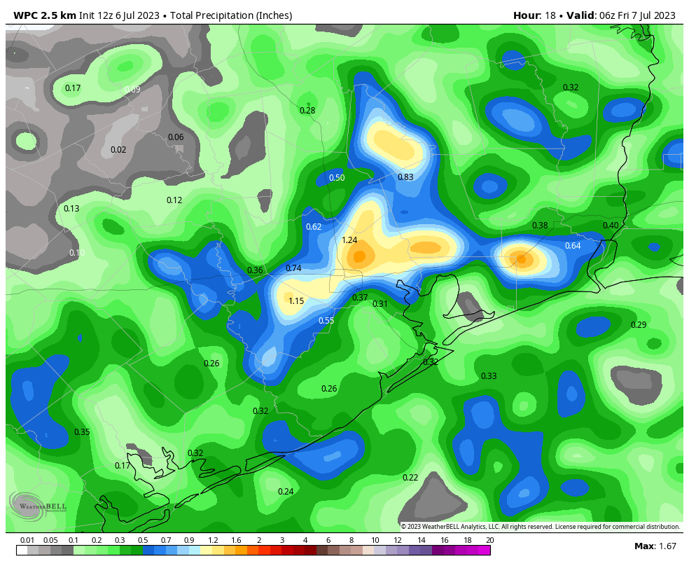
A large mass of showers and thunderstorms has developed to the southwest of our region, near Matagorda Bay. I expect these storms to gradually move toward Houston, and accordingly our chances for showers today will be highest from mid-morning through mid-afternoon. Accumulations will be widely variable, with most of the area receiving 0.5 to 1.5 inches. Flooding should not be a significant concern, but a few streets may back up under the strongest storms. Showers will end this afternoon or early evening as daytime heating ebbs. Mostly cloudy skies and rain-cooled air should limit highs today in the upper 80s to 90 degrees. Southerly winds will be light, at 5 to 10 mph, with lows tonight in the upper 70s.
Friday
Skies will turn partly to mostly sunny on Friday, and highs should perk up into the low- to mid-90s. Some additional showers will be possible during the daytime, with heating. Overall chances are probably about 40 percent, and accumulations should be much less than on Thursday.
Saturday and Sunday
This looks like a classic July weekend, with high temperatures in the mid- to upper-90s and mostly sunny skies. There is a 10 to 20 percent chance of showers each day, but probably not enough to disrupt any outdoor activities you have. Please make sure to take precautions in the heat and (very nearly) direct sunshine at midday.
Next week
I wish the outlook were better, but unfortunately we’re going to see the return of very hot weather as high pressure once again builds over the region. We are looking at highs of around 100 degrees each day, beginning Monday. We may reach extreme heat advisories at some point. It looks like the heat will persist through at least the middle of the month, as the high pressure dome looks really stout.


Thanks as always for the great forecasting, Team SCW.
Yeah 😀!
Didn’t I read last week that July would cool down and be more normal for Houston? Doesn’t look like it…
They only mentioned this week’s weather, not a forecast for the entire month. This is from last Thursday which is fairly accurate for a week away forecast:
Rest of next week
As we move beyond Independence Day, it looks as though we will ease into more of a classic midsummer pattern for Houston. It won’t be cool, but it will be noticeably less hot. We should see fewer and less regular heat advisories or warnings. Expect highs more into the mid-90s, near average for this time of year. Morning lows will be mostly in the 70s to perhaps near 80 at times. But each day will carry at least a 20 to 40 percent chance of scattered thunderstorms to locally cool things off. Rain chances should build into the end of the week, nearing 50 percent on Thursday and Friday before declining once more.
What is a good website to track the high pressure dome?
Weathernerds or Tropical Tidbits both display model forecasts for free. They have displays that show the isobars.
I love the color-coded map! Just can never remember if 610 or BW8 is shown, could anyone remind me which it is?
The 610 Loop is shown on the area weather maps. BeltWay 8 is not shown on the same map. The 610 Loop is kind of rectangle-ish, while the BeltWay is more square-ish.
Ah, that wiggle on the SE side definitely confirms it to be 610, thank you.
yesterday was the hottest day ever in the history of the planet, that is what they said.
yesterdays comments section was hot as well. Glad its much calmer today
Can we just skip the next 3 months and be in November already? Lol
Here, here! I second that!!
Me three!
Hear, hear, maybe? Unless we are all ‘here’, so to speak. 😉
I have some hope and optimism…not seeing the intensity high pressure build of last week coming in the future. The pattern is different. No dreaded omega in the jet and a 591 height instead of 594. Widespread rain today is a happy event. The sun will have to evaporate a lot of water. The tropical plants are joyful.
81 F at 2:30 in early July! I’ll take it – no complaints.
4″ of rain near Westchase so far today.
The first Ken.
Cooler 76 degrees outside as of 3pm than inside the house and a nice steady rain shower in Copperfield…
Over 2” in Katy, SE of I10 & 99. So very thankful. That’s in addition to .6” yesterday.